
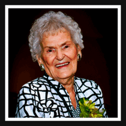
Bula Mae “Mama Bula” Lown Roof
| Birth | : | 16 Apr 1919 Springdale, Lexington County, South Carolina, USA |
| Death | : | 26 Jun 2016 Chapin, Lexington County, South Carolina, USA |
| Burial | : | Emmanuel Lutheran Church Cemetery, Lexington County, USA |
| Coordinate | : | 33.9336014, -81.1457977 |
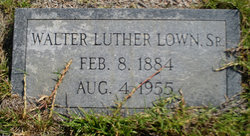
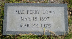
| Description | : | In Memory of Bula Mae Lown Roof ~~~~~~~~~~~~~~~~~~~~~~~~~~~~~~~~~ WEST COLUMBIA - Bula L. Roof, 97, of West Columbia, South Carolina passed away June 26, 2016 at Heritage at Lowman, in Chapin, South Carolina. She was born on April 16, 1919 in Springdale, South Carolina to the late Walter and Mae Perry Lown. She was the wife of the late Duel "Jeff" Charlton Roof. They were married 73 years. She was a lifelong resident of Springdale SC. Bula was strong in her Christian faith and was an active member at Emmanuel Lutheran Church. She dedicated a lifetime to service at her church. She... Read More |
frequently asked questions (FAQ):
-
Where is Bula Mae “Mama Bula” Lown Roof's memorial?
Bula Mae “Mama Bula” Lown Roof's memorial is located at: Emmanuel Lutheran Church Cemetery, Lexington County, USA.
-
When did Bula Mae “Mama Bula” Lown Roof death?
Bula Mae “Mama Bula” Lown Roof death on 26 Jun 2016 in Chapin, Lexington County, South Carolina, USA
-
Where are the coordinates of the Bula Mae “Mama Bula” Lown Roof's memorial?
Latitude: 33.9336014
Longitude: -81.1457977
Family Members:
Parent
Spouse

Siblings
Flowers:


Nearby Cemetories:
1. Emmanuel Lutheran Church Cemetery
Lexington County, USA
Coordinate: 33.9336014, -81.1457977
2. Laurel Baptist Church
Lexington County, USA
Coordinate: 33.9304890, -81.1424020
3. Daniel N. Shull Family Cemetery
Hamlet South, Lexington County, USA
Coordinate: 33.9528560, -81.1762940
4. Iglesia Pentecostal Church
Lexington County, USA
Coordinate: 33.8948310, -81.1332480
5. Gregory Family Cemetery
Lexington County, USA
Coordinate: 33.9579640, -81.1886300
6. Abundant Life Assembly Of God Cemetery
Lexington County, USA
Coordinate: 33.9748830, -81.1245990
7. Fish Hatchery Church of God
Gaston, Lexington County, USA
Coordinate: 33.8806370, -81.1154350
8. Emanuel Sox Cemetery
Lexington County, USA
Coordinate: 33.9936120, -81.1599400
9. Mount Pleasant Baptist Church Cemetery
Gaston, Lexington County, USA
Coordinate: 33.8729990, -81.1343500
10. Larkin Glen Cemetery
Lexington County, USA
Coordinate: 33.8713989, -81.1418991
11. Baughman Cemetery
Gaston, Lexington County, USA
Coordinate: 33.8715860, -81.1346050
12. Burnt Mill Plantation Cemetery
Lexington County, USA
Coordinate: 33.8755100, -81.1150200
13. Faith Lutheran Church Cemetery
Lexington County, USA
Coordinate: 33.9739810, -81.0825880
14. Watts Family Cemetery
Gaston, Lexington County, USA
Coordinate: 33.8723910, -81.1115050
15. Glenn Family Cemetery
Lexington County, USA
Coordinate: 33.8764650, -81.1007450
16. Corley Family Cemetery
Lexington County, USA
Coordinate: 33.9991620, -81.1812130
17. Cayce Burial Gnd
Cayce, Lexington County, USA
Coordinate: 33.9693510, -81.0675840
18. Granby Gardens Park Pavilion Cemetery
Cayce, Lexington County, USA
Coordinate: 33.9712890, -81.0677060
19. Earl Cemetery
Cayce, Lexington County, USA
Coordinate: 33.9677560, -81.0646100
20. All Saints Episcopal Church Garden
Cayce, Lexington County, USA
Coordinate: 33.9810790, -81.0695250
21. Baughman Cemetery
Lexington County, USA
Coordinate: 33.8883018, -81.0674973
22. Taylor Cemetery
Cayce, Lexington County, USA
Coordinate: 33.9661380, -81.0570790
23. Arthur Cemetery
Cayce, Lexington County, USA
Coordinate: 33.9666730, -81.0573280
24. Fridig Cemetery
Lexington County, USA
Coordinate: 33.9961600, -81.0836350