
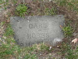
Carl Franklin Hobbs
| Birth | : | 27 Apr 1911 Oroville, Okanogan County, Washington, USA |
| Death | : | 3 May 1985 Leavenworth, Chelan County, Washington, USA |
| Burial | : | South Lawn Cemetery, Piermont, Grafton County, USA |
| Coordinate | : | 43.9667600, -72.0812500 |
| Plot | : | North Fraternal Row48 STBLK47 LS5 |
| Description | : | Carl F Hobbs, Chelan, a former resident of Oroville, died Friday evening in the Cascade General Hospital in Leavenworth. He was born April 27, 1911, in Oroville and spent his early years there. In August of 1938, he married Leona Prince. Following their marriage, they made their home in Oroville where he owned a shoe repair shop and later was active in ranching. In 1949, he was employed in the construction of the Alaskan Highway. He returned to Oroville where he was employed with the Brownson Lumber Company and later as a maintenance man at the Peerless... Read More |
frequently asked questions (FAQ):
-
Where is Carl Franklin Hobbs's memorial?
Carl Franklin Hobbs's memorial is located at: South Lawn Cemetery, Piermont, Grafton County, USA.
-
When did Carl Franklin Hobbs death?
Carl Franklin Hobbs death on 3 May 1985 in Leavenworth, Chelan County, Washington, USA
-
Where are the coordinates of the Carl Franklin Hobbs's memorial?
Latitude: 43.9667600
Longitude: -72.0812500
Family Members:
Parent

Spouse
Siblings
Flowers:


Nearby Cemetories:
1. South Lawn Cemetery
Piermont, Grafton County, USA
Coordinate: 43.9667600, -72.0812500
2. Cedar Grove Cemetery
Piermont, Grafton County, USA
Coordinate: 43.9720300, -72.0813400
3. Clay Hollow Cemetery
Piermont, Grafton County, USA
Coordinate: 43.9597220, -72.0333330
4. River Road Cemetery
Piermont, Grafton County, USA
Coordinate: 44.0019500, -72.1013600
5. Upper Plain Cemetery
Bradford, Orange County, USA
Coordinate: 44.0084900, -72.1097200
6. Sawyer Cemetery
Bradford, Orange County, USA
Coordinate: 44.0085800, -72.1101000
7. Brushwood Cemetery
Fairlee, Orange County, USA
Coordinate: 43.9628600, -72.1623700
8. Fairlee Village Cemetery
Fairlee, Orange County, USA
Coordinate: 43.9154900, -72.1321900
9. Rodimon-Cross Cemetery
Piermont, Grafton County, USA
Coordinate: 43.9901100, -71.9924500
10. West Cemetery
Orford, Grafton County, USA
Coordinate: 43.9081970, -72.1312760
11. Dame Hill Cemetery
Orford, Grafton County, USA
Coordinate: 43.8945370, -72.0833370
12. Kidderhood Cemetery
West Fairlee, Orange County, USA
Coordinate: 43.9719034, -72.1869267
13. Ladd Street Cemetery
Haverhill, Grafton County, USA
Coordinate: 44.0439600, -72.0532800
14. East Orford Cemetery
Orford, Grafton County, USA
Coordinate: 43.9096900, -72.0032600
15. East Piermont Cemetery
Piermont, Grafton County, USA
Coordinate: 43.9438890, -71.9689890
16. Goshen Cemetery (Defunct)
Bradford, Orange County, USA
Coordinate: 44.0402170, -72.1469029
17. West Bradford Cemetery
Bradford, Orange County, USA
Coordinate: 44.0031700, -72.1957600
18. Lund Cemetery
Warren, Grafton County, USA
Coordinate: 43.9882800, -71.9589200
19. Wild Hill Cemetery
West Fairlee, Orange County, USA
Coordinate: 43.9587300, -72.2070600
20. East Haverhill Cemetery
East Haverhill, Grafton County, USA
Coordinate: 44.0289688, -71.9889297
21. Bloodbrook Cemetery
West Fairlee, Orange County, USA
Coordinate: 43.9319941, -72.2026967
22. Rogers Hill Cemetery
West Newbury, Orange County, USA
Coordinate: 44.0550003, -72.1322021
23. West Newbury Cemetery
West Newbury, Orange County, USA
Coordinate: 44.0591800, -72.1246900
24. Scruton Hill Cemetery
West Fairlee, Orange County, USA
Coordinate: 43.9667705, -72.2220608