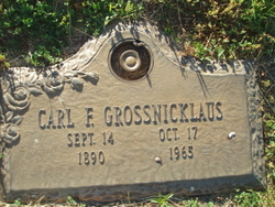
Carl Frederick “Charley” Grossnicklaus
| Birth | : | 14 Sep 1890 Polk County, Nebraska, USA |
| Death | : | 17 Oct 1965 Platte Center, Platte County, Nebraska, USA |
| Burial | : | Saint James Cemetery, Manchester, Hartford County, USA |
| Coordinate | : | 41.7752991, -72.5355988 |
frequently asked questions (FAQ):
-
Where is Carl Frederick “Charley” Grossnicklaus's memorial?
Carl Frederick “Charley” Grossnicklaus's memorial is located at: Saint James Cemetery, Manchester, Hartford County, USA.
-
When did Carl Frederick “Charley” Grossnicklaus death?
Carl Frederick “Charley” Grossnicklaus death on 17 Oct 1965 in Platte Center, Platte County, Nebraska, USA
-
Where are the coordinates of the Carl Frederick “Charley” Grossnicklaus's memorial?
Latitude: 41.7752991
Longitude: -72.5355988
Family Members:
Parent
Spouse
Siblings
Children
Flowers:
Nearby Cemetories:
1. Cheney Cemetery
Manchester, Hartford County, USA
Coordinate: 41.7773438, -72.5118713
2. East Cemetery
Manchester, Hartford County, USA
Coordinate: 41.7747002, -72.5111008
3. Beth Sholom Memorial Park
Manchester, Hartford County, USA
Coordinate: 41.7738991, -72.5061035
4. Buckland Cemetery
Manchester, Hartford County, USA
Coordinate: 41.7957993, -72.5558014
5. Saint Bridgets Cemetery
Manchester, Hartford County, USA
Coordinate: 41.8003006, -72.5218964
6. Hillstown Road Cemetery
Manchester, Hartford County, USA
Coordinate: 41.7620277, -72.5698013
7. West Cemetery
Manchester, Hartford County, USA
Coordinate: 41.7680397, -72.5733032
8. Saint John's Cemetery
Manchester, Hartford County, USA
Coordinate: 41.8046989, -72.5274963
9. Silver Lane Cemetery
East Hartford, Hartford County, USA
Coordinate: 41.7659302, -72.5859985
10. Faith Lutheran Church Memorial Garden
East Hartford, Hartford County, USA
Coordinate: 41.7667110, -72.5946570
11. Saint Marys Cemetery
East Hartford, Hartford County, USA
Coordinate: 41.7827988, -72.5986023
12. Unitarian Universalist Meetinghouse Memorial Garde
Manchester, Hartford County, USA
Coordinate: 41.8097270, -72.4902900
13. Mount Hope Cemetery
Talcottville, Tolland County, USA
Coordinate: 41.8181000, -72.4989014
14. New Wapping Cemetery
South Windsor, Hartford County, USA
Coordinate: 41.8278008, -72.5507965
15. Old Wapping Cemetery
South Windsor, Hartford County, USA
Coordinate: 41.8273964, -72.5532150
16. Holy Cross Cemetery
Glastonbury, Hartford County, USA
Coordinate: 41.7166710, -72.5606613
17. Hillside Cemetery
East Hartford, Hartford County, USA
Coordinate: 41.7714005, -72.6185989
18. Saint Peter's Memorial Garden
South Windsor, Hartford County, USA
Coordinate: 41.8361940, -72.5548830
19. Buckingham Cemetery
Glastonbury, Hartford County, USA
Coordinate: 41.7120094, -72.5229721
20. Southwest Cemetery
Vernon, Tolland County, USA
Coordinate: 41.8319016, -72.4938965
21. Old Eastbury Cemetery
Glastonbury, Hartford County, USA
Coordinate: 41.7043991, -72.5318985
22. Saint Johns Memorial Garden
Vernon, Tolland County, USA
Coordinate: 41.8318210, -72.4767140
23. Our Saviour Cemetery
Glastonbury, Hartford County, USA
Coordinate: 41.7033005, -72.5725021
24. Valley Falls Cemetery
Vernon, Tolland County, USA
Coordinate: 41.8279915, -72.4592590

