
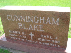
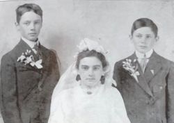
Carl James Cunningham
| Birth | : | 5 Nov 1895 Dougherty, Cerro Gordo County, Iowa, USA |
| Death | : | 28 Sep 1958 Waukon, Allamakee County, Iowa, USA |
| Burial | : | Riverside Cemetery, Rockford, Floyd County, USA |
| Coordinate | : | 43.0578003, -92.9464035 |
| Plot | : | Section 15 |
| Description | : | Mason City Globe Gazette, Mason City, Iowa September 29, 1958 Carl Cunningham Dies at Waukon; Rites Wednesday ROCKFORD - Carl Cunningham, 62, died Sunday at Waukon. He was born Nov. 5, 1895 in Dougherty. He was married Feb. 5, 1919, to Minnie Blake at Dougherty. Cunningham operated the creamery here for eight years and was manager of the hemp plant here during the war years. He was field man for the Waukon creamery at the time of his death. Surviving are his wife, two sons, Carlyle, Des Moines and R. E. Cunningham, Cedar Falls; four grandchildren and his mother, Susan Cunningham, Dougherty. The Rosary will... Read More |
frequently asked questions (FAQ):
-
Where is Carl James Cunningham's memorial?
Carl James Cunningham's memorial is located at: Riverside Cemetery, Rockford, Floyd County, USA.
-
When did Carl James Cunningham death?
Carl James Cunningham death on 28 Sep 1958 in Waukon, Allamakee County, Iowa, USA
-
Where are the coordinates of the Carl James Cunningham's memorial?
Latitude: 43.0578003
Longitude: -92.9464035
Family Members:
Parent
Spouse
Siblings


Children
Flowers:


Nearby Cemetories:
1. Riverside Cemetery
Rockford, Floyd County, USA
Coordinate: 43.0578003, -92.9464035
2. Ulsterville Cemetery
Ulster Township, Floyd County, USA
Coordinate: 43.0936012, -92.8842010
3. Flood Creek Cemetery
Floyd County, USA
Coordinate: 43.0391998, -92.8538971
4. Rock Grove Township Cemetery
Nora Springs, Floyd County, USA
Coordinate: 43.1227989, -92.9880981
5. Rudd Evergreen Cemetery
Rudd, Floyd County, USA
Coordinate: 43.1417007, -92.9214020
6. Park Cemetery
Nora Springs, Floyd County, USA
Coordinate: 43.1444016, -92.9982986
7. Saint Marys Catholic Cemetery
Roseville, Floyd County, USA
Coordinate: 43.0090000, -92.8134000
8. West Saint Charles United Methodist Cemetery
Floyd County, USA
Coordinate: 43.0580597, -92.7897186
9. Westside Cemetery
Marble Rock, Floyd County, USA
Coordinate: 42.9556007, -92.8739014
10. Hillside Cemetery
Marble Rock, Floyd County, USA
Coordinate: 42.9583015, -92.8666992
11. Spring Grove Cemetery
Nora Springs, Floyd County, USA
Coordinate: 43.1631012, -93.0211029
12. Owens Grove Cemetery
Cerro Gordo County, USA
Coordinate: 43.0825005, -93.1144180
13. Saint Patricks Catholic Cemetery
Dougherty, Cerro Gordo County, USA
Coordinate: 42.9227791, -93.0294418
14. Eden Presbyterian Cemetery
Meroa, Mitchell County, USA
Coordinate: 43.2131004, -92.9103012
15. West End Cemetery
Meroa, Mitchell County, USA
Coordinate: 43.2216682, -92.9250031
16. Oakwood Cemetery
Floyd, Floyd County, USA
Coordinate: 43.1178017, -92.7307968
17. Dudley Cemetery
Dudley (historical), Mitchell County, USA
Coordinate: 43.2252998, -92.8743973
18. Rock Creek Cemetery
Meroa, Mitchell County, USA
Coordinate: 43.2352791, -92.9225006
19. Halls Grove Cemetery
Greene, Butler County, USA
Coordinate: 42.8840100, -92.8782300
20. Rock Falls Cemetery
Rock Falls, Cerro Gordo County, USA
Coordinate: 43.2122192, -93.0858307
21. Pleasant Grove Cemetery
Powersville, Floyd County, USA
Coordinate: 42.9441986, -92.7446976
22. Calvary Cemetery
Osage, Mitchell County, USA
Coordinate: 43.2238998, -92.8300018
23. Riverside Cemetery
Charles City, Floyd County, USA
Coordinate: 43.0766983, -92.6881027
24. West Fork Cemetery
Franklin County, USA
Coordinate: 42.8918991, -93.0836029