
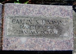

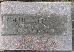

Carlin Sharpless “Calvin” Kinman
| Birth | : | 10 Mar 1846 Pekin, Tazewell County, Illinois, USA |
| Death | : | 18 Jan 1932 Table Bluff, Humboldt County, California, USA |
| Burial | : | Ceres Memorial Park, Ceres, Stanislaus County, USA |
| Coordinate | : | 37.5958214, -120.9634399 |
| Plot | : | About thirty feet from the entrance gate. |
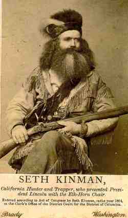
| Description | : | Blue Lake Advocate, Volume 44, Number 39, 23 January 1932 County Pioneer Dies At His Home At Table Bluff Carlin S. Kinman, one of the early pioneers of Humboldt county, died at his home at Table Bluff Monday morning at the age of 85 years, 10 months, 8 days. He was bom in Pekin, Illinois, March 10, 1846. At the age of eight he crossed the plains with his father, Seth Kinman, an old time hunter and trapper in the early days of Humboldt coming to this county where he spent the remainder of his life. He leaves to mourn... Read More |
frequently asked questions (FAQ):
-
Where is Carlin Sharpless “Calvin” Kinman's memorial?
Carlin Sharpless “Calvin” Kinman's memorial is located at: Ceres Memorial Park, Ceres, Stanislaus County, USA.
-
When did Carlin Sharpless “Calvin” Kinman death?
Carlin Sharpless “Calvin” Kinman death on 18 Jan 1932 in Table Bluff, Humboldt County, California, USA
-
Where are the coordinates of the Carlin Sharpless “Calvin” Kinman's memorial?
Latitude: 37.5958214
Longitude: -120.9634399
Family Members:
Parent
Spouse
Siblings

Flowers:


Nearby Cemetories:
1. Ceres Memorial Park
Ceres, Stanislaus County, USA
Coordinate: 37.5958214, -120.9634399
2. Saint Stanislaus Catholic Cemetery
Modesto, Stanislaus County, USA
Coordinate: 37.6473610, -120.9808440
3. Modesto Pioneer Cemetery
Modesto, Stanislaus County, USA
Coordinate: 37.6473350, -120.9829040
4. Modesto Citizens Cemetery
Modesto, Stanislaus County, USA
Coordinate: 37.6472930, -120.9845570
5. Acacia Memorial Park
Modesto, Stanislaus County, USA
Coordinate: 37.6481080, -120.9836610
6. Modesto County Cemetery
Modesto, Stanislaus County, USA
Coordinate: 37.6492400, -120.9813800
7. Lakewood Memorial Park
Hughson, Stanislaus County, USA
Coordinate: 37.6199760, -120.8975983
8. Good Shepherd Catholic Cemetery
Modesto, Stanislaus County, USA
Coordinate: 37.6853130, -121.0672890
9. Wood Colony Cemetery
Salida, Stanislaus County, USA
Coordinate: 37.6893730, -121.0682144
10. Turlock Memorial Park
Turlock, Stanislaus County, USA
Coordinate: 37.4937592, -120.8659821
11. Denair Cemetery
Denair, Stanislaus County, USA
Coordinate: 37.5293999, -120.8199997
12. Saint Francis Episcopal Church Columbarium
Turlock, Stanislaus County, USA
Coordinate: 37.5014300, -120.8368400
13. Burwood Cemetery
Escalon, San Joaquin County, USA
Coordinate: 37.7616997, -120.9593964
14. Langworth Cemetery
Oakdale, Stanislaus County, USA
Coordinate: 37.7580986, -120.8957977
15. Grayson Cemetery
Grayson, Stanislaus County, USA
Coordinate: 37.5594559, -121.1802826
16. Martin Cemetery
Waterford, Stanislaus County, USA
Coordinate: 37.6684360, -120.7582160
17. Patterson District Cemetery
Patterson, Stanislaus County, USA
Coordinate: 37.5268135, -121.1728287
18. North Hilmar Cemetery
Hilmar, Merced County, USA
Coordinate: 37.4146614, -120.8864288
19. Oakdale Citizens Cemetery
Oakdale, Stanislaus County, USA
Coordinate: 37.7624600, -120.8388800
20. Ripon Cemetery
Ripon, San Joaquin County, USA
Coordinate: 37.7420311, -121.1238708
21. Oaklawn Memorial Park
Oakdale, Stanislaus County, USA
Coordinate: 37.7711945, -120.8486862
22. Saint John's Catholic Cemetery
Escalon, San Joaquin County, USA
Coordinate: 37.7994537, -121.0705185
23. South Hilmar Cemetery
Hilmar, Merced County, USA
Coordinate: 37.3802681, -120.8868408
24. Valley Home Memorial Park
Oakdale, Stanislaus County, USA
Coordinate: 37.8275528, -120.9333267