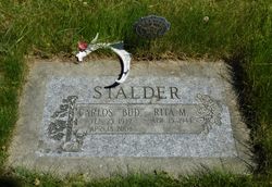
Carlos H “Bud” Stalder
| Birth | : | 25 Feb 1939 Omak, Okanogan County, Washington, USA |
| Death | : | 18 Apr 2008 Wenatchee, Chelan County, Washington, USA |
| Burial | : | Mountain View Cemetery, Loomis, Okanogan County, USA |
| Coordinate | : | 48.8152700, -119.6100100 |
| Inscription | : | STALDER CARLOS "BUD" FEB. 25, 1939 APR. 18, 2008 RITA M. APR. 15, 1944 |
| Description | : | Carlos H. "Bud" Stalder, 69, of Tonasket, died Friday, April 18, 2008, in Wenatchee. He had lived in Omak and Tonasket, and retired from the U.S. Forest Service in 1994. Survivors include his wife, Rita Stalder of Tonasket; his stepchildren, Dee Johnson of Tonasket, Mike Rehmke of Okanogan, Raymond McGlothlin of Wenatchee and Christopher McGlothlin of Oroville; and his brother, Floyd "Merf" Stalder of Addy. A memorial service will be held at 11 a.m. Saturday at the Tonasket Lutheran Church. A luncheon will follow at the Tonasket Eagles. Arrangements are by Bergh Funeral Service of Tonasket. |
frequently asked questions (FAQ):
-
Where is Carlos H “Bud” Stalder's memorial?
Carlos H “Bud” Stalder's memorial is located at: Mountain View Cemetery, Loomis, Okanogan County, USA.
-
When did Carlos H “Bud” Stalder death?
Carlos H “Bud” Stalder death on 18 Apr 2008 in Wenatchee, Chelan County, Washington, USA
-
Where are the coordinates of the Carlos H “Bud” Stalder's memorial?
Latitude: 48.8152700
Longitude: -119.6100100
Family Members:
Parent
Siblings
Children
Flowers:
Nearby Cemetories:
1. Mountain View Cemetery
Loomis, Okanogan County, USA
Coordinate: 48.8152700, -119.6100100
2. Little Chopaka Cemetery
Okanogan County, USA
Coordinate: 48.8272200, -119.6430600
3. Golden Cemetery
Okanogan County, USA
Coordinate: 48.9014015, -119.5203018
4. Old Oroville Cemetery
Okanogan County, USA
Coordinate: 48.8913360, -119.4456230
5. Mountain View Memorial Cemetery
Ellisforde, Okanogan County, USA
Coordinate: 48.8328300, -119.4011300
6. Ellisforde Mission Cemetery
Ellisforde, Okanogan County, USA
Coordinate: 48.7908300, -119.3972300
7. Tonasket Cemetery
Tonasket, Okanogan County, USA
Coordinate: 48.7284400, -119.4328200
8. Old Riverview Cemetery
Oroville, Okanogan County, USA
Coordinate: 48.9177800, -119.4466700
9. Oroville Riverview Cemetery
Oroville, Okanogan County, USA
Coordinate: 48.9202700, -119.4458500
10. Pine Creek Cemetery
Tonasket, Okanogan County, USA
Coordinate: 48.6330560, -119.6502780
11. South Pine Creek Cemetery
Riverside, Okanogan County, USA
Coordinate: 48.5925900, -119.5663400
12. Osoyoos Lakeview Cemetery
Osoyoos, Okanagan-Similkameen Regional District, Canada
Coordinate: 49.0638600, -119.5185500
13. Phillip Raux Gravesite
Riverside, Okanogan County, USA
Coordinate: 48.6271800, -119.3308500
14. Anglin Cemetery
Okanogan County, USA
Coordinate: 48.6627700, -119.2783400
15. Cook Place Cemetery
Tonasket, Okanogan County, USA
Coordinate: 48.6083330, -119.3544440
16. Cook Family Cemetery
Carlton, Okanogan County, USA
Coordinate: 48.6083300, -119.3544400
17. Immanuel Lutheran Cemetery
Havillah, Okanogan County, USA
Coordinate: 48.8305500, -119.2033500
18. Conconully Cemetery
Conconully, Okanogan County, USA
Coordinate: 48.5441600, -119.7400100
19. Molson Cemetery
Molson, Okanogan County, USA
Coordinate: 48.9657000, -119.2105000
20. Valley Congregational Church Memorial Rose Garden
Oliver, Okanagan-Similkameen Regional District, Canada
Coordinate: 49.1169070, -119.5575920
21. Kipling Cemetery
Okanogan County, USA
Coordinate: 48.9080500, -119.1652900
22. Ruby Cemetery
Okanogan County, USA
Coordinate: 48.5085983, -119.7221985
23. Sidley-Lawless Cemetery
Sidley, Kootenay Boundary Regional District, Canada
Coordinate: 49.0153330, -119.2234330
24. Riverside Cemetery
Riverside, Okanogan County, USA
Coordinate: 48.4944400, -119.5022200


