
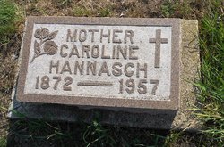
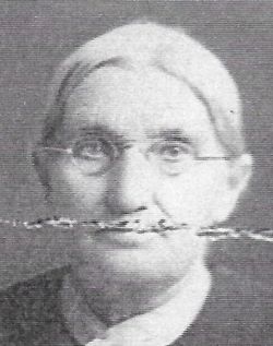
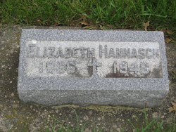
Caroline “Carrie” Puttmann Hannasch
| Birth | : | 6 Feb 1872 Festina, Winneshiek County, Iowa, USA |
| Death | : | 11 Apr 1957 Fort Dodge, Webster County, Iowa, USA |
| Burial | : | Mount Olivet Cemetery, Carroll, Carroll County, USA |
| Coordinate | : | 42.0536340, -94.8595510 |
| Description | : | Caroline was the daughter of Bernard Puttmann and Sibilla Tempe. She married Joseph Hannasch on 21 Jan 1891 at Roselle, Carroll, Iowa. They were the parents of Henry, Mary, Ann, Margaret, Irene, Leone, George, Genevieve, Carl, and Edna. April 12, 1957 - Carroll Daily Times - Mrs. Hannasch, widow of Joseph Hannasch had lived in Fort Dodge the last 14 years. She died at 5 a.m. Thursday at St. Joseph Mercy Hospital, Fort Dodge, after a six-month illness. The former Caroline Puttman was born Feb. 6, 1872, at Festina, Ia. At the age of two years, she came to... Read More |
frequently asked questions (FAQ):
-
Where is Caroline “Carrie” Puttmann Hannasch's memorial?
Caroline “Carrie” Puttmann Hannasch's memorial is located at: Mount Olivet Cemetery, Carroll, Carroll County, USA.
-
When did Caroline “Carrie” Puttmann Hannasch death?
Caroline “Carrie” Puttmann Hannasch death on 11 Apr 1957 in Fort Dodge, Webster County, Iowa, USA
-
Where are the coordinates of the Caroline “Carrie” Puttmann Hannasch's memorial?
Latitude: 42.0536340
Longitude: -94.8595510
Family Members:
Parent

Spouse
Siblings
Children
Flowers:


Nearby Cemetories:
1. Mount Olivet Cemetery
Carroll, Carroll County, USA
Coordinate: 42.0536340, -94.8595510
2. Carroll City Cemetery
Carroll, Carroll County, USA
Coordinate: 42.0560963, -94.8599856
3. Holy Angels Cemetery
Carroll County, USA
Coordinate: 42.0014000, -94.9141998
4. Saint Francis Cemetery
Maple River, Carroll County, USA
Coordinate: 42.0969009, -94.9372025
5. Saint Marys Catholic Cemetery
Willey, Carroll County, USA
Coordinate: 41.9783363, -94.8212204
6. Holy Family Cemetery
Lidderdale, Carroll County, USA
Coordinate: 42.1178017, -94.7839966
7. West Lawn Cemetery
Glidden, Carroll County, USA
Coordinate: 42.0649986, -94.7406006
8. Immanuel Cemetery
Lidderdale, Carroll County, USA
Coordinate: 42.1389008, -94.8022003
9. Saint Augustine Cemetery
Halbur, Carroll County, USA
Coordinate: 42.0066986, -94.9744034
10. Our Lady Of Mount Carmel Cemetery
Mount Carmel, Carroll County, USA
Coordinate: 42.1547012, -94.9088974
11. Arcadia Cemetery
Arcadia Township, Carroll County, USA
Coordinate: 42.1000680, -95.0130550
12. East Liberty Cemetery
Lidderdale, Carroll County, USA
Coordinate: 42.1591988, -94.7636032
13. McCurdy Cemetery
Carroll County, USA
Coordinate: 41.9403000, -94.7649994
14. Saint Johns Catholic Cemetery
Arcadia, Carroll County, USA
Coordinate: 42.0855406, -95.0341577
15. Dickson Cemetery
Glidden Township, Carroll County, USA
Coordinate: 42.1074982, -94.6939011
16. Saint Bernards Cemetery
Breda, Carroll County, USA
Coordinate: 42.1786003, -94.9732971
17. Elba Cemetery
Templeton, Carroll County, USA
Coordinate: 41.9068985, -94.9131012
18. Sacred Heart Cemetery
Templeton, Carroll County, USA
Coordinate: 41.9138746, -94.9460994
19. Dedham Cemetery
Dedham, Carroll County, USA
Coordinate: 41.8993988, -94.8225021
20. Saint Josephs Cemetery
Dedham, Carroll County, USA
Coordinate: 41.8993988, -94.8210983
21. North Coon Cemetery
Carroll County, USA
Coordinate: 42.1260986, -94.6716995
22. Old Carrollton Cemetery
Carrollton, Carroll County, USA
Coordinate: 41.9233017, -94.7403030
23. Lanesboro Cemetery
Lanesboro, Carroll County, USA
Coordinate: 42.1810989, -94.7230988
24. Luckow Cemetery
Auburn, Sac County, USA
Coordinate: 42.2168999, -94.9266968