
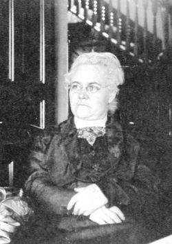
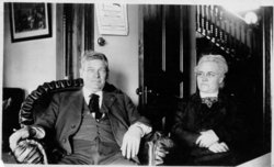
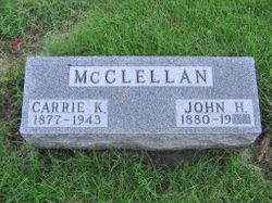
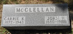
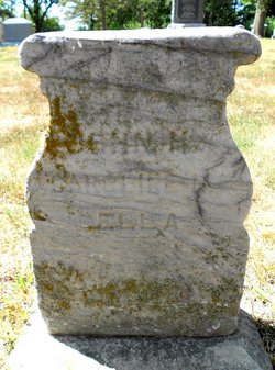
Caroline K “Carrie” Kelly McClellan
| Birth | : | 21 May 1877 Iowa, USA |
| Death | : | 29 Apr 1943 Omaha, Douglas County, Nebraska, USA |
| Burial | : | Carroll City Cemetery, Carroll, Carroll County, USA |
| Coordinate | : | 42.0560963, -94.8599856 |
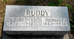
| Description | : | April 29, 1943 - Carroll Times - Mrs. J.H. McClellan of Omaha, who formerly lived in Carroll for many years, died in Omaha at 5 o'clock this morning, her death resulting from a stroke which she suffered Tuesday night. Mrs. McClellan had been in poor health since three years ago Easter Sunday, when she suffered her first stroke. She would have been 66 years old in May. Her only sister, Mrs. Frank Ruddy, went to Omaha yesterday noon because of her critical condition. The body is being brought to Carroll for burial, and graveside services are to be held in... Read More |
frequently asked questions (FAQ):
-
Where is Caroline K “Carrie” Kelly McClellan's memorial?
Caroline K “Carrie” Kelly McClellan's memorial is located at: Carroll City Cemetery, Carroll, Carroll County, USA.
-
When did Caroline K “Carrie” Kelly McClellan death?
Caroline K “Carrie” Kelly McClellan death on 29 Apr 1943 in Omaha, Douglas County, Nebraska, USA
-
Where are the coordinates of the Caroline K “Carrie” Kelly McClellan's memorial?
Latitude: 42.0560963
Longitude: -94.8599856
Family Members:
Parent

Spouse

Siblings

Children
Flowers:


Nearby Cemetories:
1. Carroll City Cemetery
Carroll, Carroll County, USA
Coordinate: 42.0560963, -94.8599856
2. Mount Olivet Cemetery
Carroll, Carroll County, USA
Coordinate: 42.0536340, -94.8595510
3. Holy Angels Cemetery
Carroll County, USA
Coordinate: 42.0014000, -94.9141998
4. Saint Francis Cemetery
Maple River, Carroll County, USA
Coordinate: 42.0969009, -94.9372025
5. Saint Marys Catholic Cemetery
Willey, Carroll County, USA
Coordinate: 41.9783363, -94.8212204
6. Holy Family Cemetery
Lidderdale, Carroll County, USA
Coordinate: 42.1178017, -94.7839966
7. West Lawn Cemetery
Glidden, Carroll County, USA
Coordinate: 42.0649986, -94.7406006
8. Immanuel Cemetery
Lidderdale, Carroll County, USA
Coordinate: 42.1389008, -94.8022003
9. Saint Augustine Cemetery
Halbur, Carroll County, USA
Coordinate: 42.0066986, -94.9744034
10. Our Lady Of Mount Carmel Cemetery
Mount Carmel, Carroll County, USA
Coordinate: 42.1547012, -94.9088974
11. Arcadia Cemetery
Arcadia Township, Carroll County, USA
Coordinate: 42.1000680, -95.0130550
12. East Liberty Cemetery
Lidderdale, Carroll County, USA
Coordinate: 42.1591988, -94.7636032
13. Saint Johns Catholic Cemetery
Arcadia, Carroll County, USA
Coordinate: 42.0855406, -95.0341577
14. Dickson Cemetery
Glidden Township, Carroll County, USA
Coordinate: 42.1074982, -94.6939011
15. McCurdy Cemetery
Carroll County, USA
Coordinate: 41.9403000, -94.7649994
16. Saint Bernards Cemetery
Breda, Carroll County, USA
Coordinate: 42.1786003, -94.9732971
17. Elba Cemetery
Templeton, Carroll County, USA
Coordinate: 41.9068985, -94.9131012
18. Sacred Heart Cemetery
Templeton, Carroll County, USA
Coordinate: 41.9138746, -94.9460994
19. North Coon Cemetery
Carroll County, USA
Coordinate: 42.1260986, -94.6716995
20. Dedham Cemetery
Dedham, Carroll County, USA
Coordinate: 41.8993988, -94.8225021
21. Saint Josephs Cemetery
Dedham, Carroll County, USA
Coordinate: 41.8993988, -94.8210983
22. Old Carrollton Cemetery
Carrollton, Carroll County, USA
Coordinate: 41.9233017, -94.7403030
23. Lanesboro Cemetery
Lanesboro, Carroll County, USA
Coordinate: 42.1810989, -94.7230988
24. Luckow Cemetery
Auburn, Sac County, USA
Coordinate: 42.2168999, -94.9266968