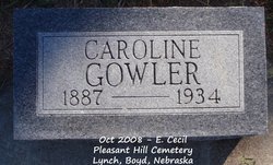
Caroline Matilda Ericksen Gowler
| Birth | : | 30 Nov 1887 Nebraska, USA |
| Death | : | 21 Sep 1934 Mission, Todd County, South Dakota, USA |
| Burial | : | Hexham Cemetery, Hexham, Northumberland Unitary Authority, England |
| Coordinate | : | 54.9788580, -2.1276740 |
| Description | : | Spencer Advocate (NE); 27 Sep 1934; p1 Funeral services were held Tuesday, Sept 24 at the Presbyterian church at 2:30, for Mrs. Thos. Gowler, well-known Lynch business owners of the early days. Caroline Matilda Ericksen was born at Harding, Nebr., November 30, 1887, and died Sept. 21, 1934 at her home in Mission, S.D., at the age of 47 years, 9 months and 21 days. She moved to Boyd county with her parents in the early days and graduated from the Spencer High School. At the age of 18 she joined the Congregational church where she was a faithful member until her death.... Read More |
frequently asked questions (FAQ):
-
Where is Caroline Matilda Ericksen Gowler's memorial?
Caroline Matilda Ericksen Gowler's memorial is located at: Hexham Cemetery, Hexham, Northumberland Unitary Authority, England.
-
When did Caroline Matilda Ericksen Gowler death?
Caroline Matilda Ericksen Gowler death on 21 Sep 1934 in Mission, Todd County, South Dakota, USA
-
Where are the coordinates of the Caroline Matilda Ericksen Gowler's memorial?
Latitude: 54.9788580
Longitude: -2.1276740
Family Members:
Spouse
Children
Flowers:
Nearby Cemetories:
1. Hexham Cemetery
Hexham, Northumberland Unitary Authority, England
Coordinate: 54.9788580, -2.1276740
2. St Andrew's Cemetery
Haydon Bridge, Northumberland Unitary Authority, England
Coordinate: 54.9788680, -2.1276850
3. St John of Beverley Churchyard
Acomb, Northumberland Unitary Authority, England
Coordinate: 54.9859680, -2.1061560
4. St John Lee, St John of Beverley Old Churchyard
Hexham, Northumberland Unitary Authority, England
Coordinate: 54.9860620, -2.1056870
5. St. John Lee of Beverley New Churchyard
Acomb, Northumberland Unitary Authority, England
Coordinate: 54.9861290, -2.1049280
6. Hexham Abbey
Hexham, Northumberland Unitary Authority, England
Coordinate: 54.9715940, -2.1026190
7. St Mary Roman Catholic Churchyard
Hexham, Northumberland Unitary Authority, England
Coordinate: 54.9697070, -2.1040520
8. Dilston Castle Chapelyard
Corbridge, Northumberland Unitary Authority, England
Coordinate: 54.9639270, -2.0393460
9. St Peter's Churchyard
Humshaugh, Northumberland Unitary Authority, England
Coordinate: 55.0368780, -2.1264880
10. Corbridge Cemetery
Corbridge, Northumberland Unitary Authority, England
Coordinate: 54.9693100, -2.0263500
11. St Andrew's Churchyard
Corbridge, Northumberland Unitary Authority, England
Coordinate: 54.9745300, -2.0197400
12. St Giles Churchyard
Chollerton, Northumberland Unitary Authority, England
Coordinate: 55.0414100, -2.1094900
13. St Cuthbert Churchyard
Haydon Bridge, Northumberland Unitary Authority, England
Coordinate: 54.9740620, -2.2473570
14. Haydon Bridge Cemetery
Haydon Bridge, Northumberland Unitary Authority, England
Coordinate: 54.9694700, -2.2467715
15. Haydon Bridge Churchyard Extension
Haydon Bridge, Northumberland Unitary Authority, England
Coordinate: 54.9766250, -2.2478820
16. Haydon Old Churchyard
Haydon Bridge, Northumberland Unitary Authority, England
Coordinate: 54.9818710, -2.2483010
17. St Oswalds Churchyard
Halton, Northumberland Unitary Authority, England
Coordinate: 55.0050180, -2.0048830
18. St. Mary's Roman Catholic Churchyard
Great Swinburne, Northumberland Unitary Authority, England
Coordinate: 55.0748020, -2.0998430
19. St John's Churchyard
Healey, Northumberland Unitary Authority, England
Coordinate: 54.9200850, -1.9790940
20. St. Cuthbert's Churchyard
Allendale, Northumberland Unitary Authority, England
Coordinate: 54.8978260, -2.2545020
21. Friends Meeting House
Allendale, Northumberland Unitary Authority, England
Coordinate: 54.8957750, -2.2598490
22. Allendale Old Cemetery
Allendale, Northumberland Unitary Authority, England
Coordinate: 54.8941650, -2.2612690
23. Allendale Woodland Cemetery
Allendale, Northumberland Unitary Authority, England
Coordinate: 54.8932624, -2.2618136
24. St. Cuthbert's Churchyard
Beltingham, Northumberland Unitary Authority, England
Coordinate: 54.9694330, -2.3305080


