
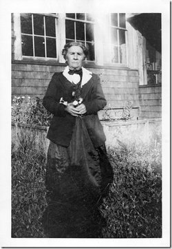

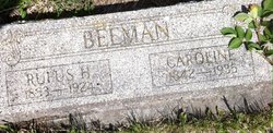
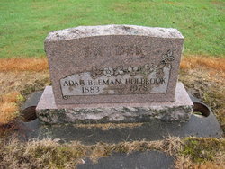
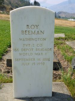
Caroline McBee Beeman
| Birth | : | 19 Feb 1842 Millville, Ray County, Missouri, USA |
| Death | : | 11 Jun 1935 Loomis, Okanogan County, Washington, USA |
| Burial | : | Mountain View Cemetery, Loomis, Okanogan County, USA |
| Coordinate | : | 48.8152700, -119.6100100 |
| Description | : | Caroline was one of 7 children born to Levi McBee and Elizabeth Ream. In 1852 she left Missouri headed out on the Oregon trail. The train had 15 oxen teams two of which were owned by her father . The train was mainly made up of Family members. Shortly after crossing the Platte River her Father got Cholera within 24 hrs he died shortly after that her Mother and two siblings also died of Cholera . The 5 remaining McBee children now in the care of Bachelor Uncles continued on to Oregon . In 1856 at the age of 14... Read More |
frequently asked questions (FAQ):
-
Where is Caroline McBee Beeman's memorial?
Caroline McBee Beeman's memorial is located at: Mountain View Cemetery, Loomis, Okanogan County, USA.
-
When did Caroline McBee Beeman death?
Caroline McBee Beeman death on 11 Jun 1935 in Loomis, Okanogan County, Washington, USA
-
Where are the coordinates of the Caroline McBee Beeman's memorial?
Latitude: 48.8152700
Longitude: -119.6100100
Family Members:
Parent

Spouse
Siblings
Children
Flowers:


Nearby Cemetories:
1. Mountain View Cemetery
Loomis, Okanogan County, USA
Coordinate: 48.8152700, -119.6100100
2. Little Chopaka Cemetery
Okanogan County, USA
Coordinate: 48.8272200, -119.6430600
3. Golden Cemetery
Okanogan County, USA
Coordinate: 48.9014015, -119.5203018
4. Old Oroville Cemetery
Okanogan County, USA
Coordinate: 48.8913360, -119.4456230
5. Mountain View Memorial Cemetery
Ellisforde, Okanogan County, USA
Coordinate: 48.8328300, -119.4011300
6. Ellisforde Mission Cemetery
Ellisforde, Okanogan County, USA
Coordinate: 48.7908300, -119.3972300
7. Tonasket Cemetery
Tonasket, Okanogan County, USA
Coordinate: 48.7284400, -119.4328200
8. Old Riverview Cemetery
Oroville, Okanogan County, USA
Coordinate: 48.9177800, -119.4466700
9. Oroville Riverview Cemetery
Oroville, Okanogan County, USA
Coordinate: 48.9202700, -119.4458500
10. Pine Creek Cemetery
Tonasket, Okanogan County, USA
Coordinate: 48.6330560, -119.6502780
11. South Pine Creek Cemetery
Riverside, Okanogan County, USA
Coordinate: 48.5925900, -119.5663400
12. Osoyoos Lakeview Cemetery
Osoyoos, Okanagan-Similkameen Regional District, Canada
Coordinate: 49.0638600, -119.5185500
13. Phillip Raux Gravesite
Riverside, Okanogan County, USA
Coordinate: 48.6271800, -119.3308500
14. Anglin Cemetery
Okanogan County, USA
Coordinate: 48.6627700, -119.2783400
15. Cook Place Cemetery
Tonasket, Okanogan County, USA
Coordinate: 48.6083330, -119.3544440
16. Cook Family Cemetery
Carlton, Okanogan County, USA
Coordinate: 48.6083300, -119.3544400
17. Immanuel Lutheran Cemetery
Havillah, Okanogan County, USA
Coordinate: 48.8305500, -119.2033500
18. Conconully Cemetery
Conconully, Okanogan County, USA
Coordinate: 48.5441600, -119.7400100
19. Molson Cemetery
Molson, Okanogan County, USA
Coordinate: 48.9657000, -119.2105000
20. Valley Congregational Church Memorial Rose Garden
Oliver, Okanagan-Similkameen Regional District, Canada
Coordinate: 49.1169070, -119.5575920
21. Kipling Cemetery
Okanogan County, USA
Coordinate: 48.9080500, -119.1652900
22. Ruby Cemetery
Okanogan County, USA
Coordinate: 48.5085983, -119.7221985
23. Sidley-Lawless Cemetery
Sidley, Kootenay Boundary Regional District, Canada
Coordinate: 49.0153330, -119.2234330
24. Riverside Cemetery
Riverside, Okanogan County, USA
Coordinate: 48.4944400, -119.5022200