

Caroline Nancy “Carrie” Belyea Polson
| Birth | : | 17 Mar 1841 Saint John, Saint John County, New Brunswick, Canada |
| Death | : | 11 Jun 1941 Seattle, King County, Washington, USA |
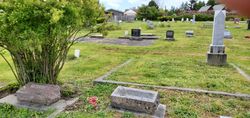
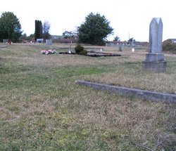
| Burial | : | Laurel Grove Cemetery, Port Townsend, Jefferson County, USA |
| Coordinate | : | 48.1169014, -122.7844009 |
| Plot | : | blk 91/7 |
| Description | : | Burial Jun 14, 1941 |
frequently asked questions (FAQ):
-
Where is Caroline Nancy “Carrie” Belyea Polson's memorial?
Caroline Nancy “Carrie” Belyea Polson's memorial is located at: Laurel Grove Cemetery, Port Townsend, Jefferson County, USA.
-
When did Caroline Nancy “Carrie” Belyea Polson death?
Caroline Nancy “Carrie” Belyea Polson death on 11 Jun 1941 in Seattle, King County, Washington, USA
-
Where are the coordinates of the Caroline Nancy “Carrie” Belyea Polson's memorial?
Latitude: 48.1169014
Longitude: -122.7844009
Family Members:
Parent

Spouse

Siblings
Children
Flowers:


Nearby Cemetories:
1. Laurel Grove Cemetery
Port Townsend, Jefferson County, USA
Coordinate: 48.1169014, -122.7844009
2. Jefferson County Cemetery
Port Townsend, Jefferson County, USA
Coordinate: 48.1178470, -122.7848340
3. Redmens Cemetery
Port Townsend, Jefferson County, USA
Coordinate: 48.1180700, -122.7830070
4. Grace Lutheran Church Columbarium
Port Townsend, Jefferson County, USA
Coordinate: 48.1163490, -122.7718970
5. Saint Marys Catholic Cemetery
Port Townsend, Jefferson County, USA
Coordinate: 48.1300250, -122.7778980
6. Saint Paul's Columbarium
Port Townsend, Jefferson County, USA
Coordinate: 48.1153400, -122.7590590
7. Fort Worden Military Cemetery
Port Townsend, Jefferson County, USA
Coordinate: 48.1333000, -122.7736000
8. Fort Townsend Post Cemetery
Jefferson County, USA
Coordinate: 48.0733760, -122.7905630
9. Camp Casey Conference Center Memorial Garden
Coupeville, Island County, USA
Coordinate: 48.1622600, -122.6819070
10. Sound View Cemetery
Nordland, Jefferson County, USA
Coordinate: 48.0457993, -122.6828003
11. Sunnyside Cemetery
Coupeville, Island County, USA
Coordinate: 48.2060350, -122.7049150
12. Greenwood Cemetery
Chimacum, Jefferson County, USA
Coordinate: 48.0103760, -122.7668080
13. Gardiner Cemetery
Gardiner, Jefferson County, USA
Coordinate: 48.0473150, -122.9185530
14. Snarling Cemetery
Coupeville, Island County, USA
Coordinate: 48.2200012, -122.6849976
15. Discovery Bay Cemetery
Maynard, Jefferson County, USA
Coordinate: 48.0001440, -122.8773080
16. Bush Point Cemetery
Freeland, Island County, USA
Coordinate: 48.0260840, -122.5952550
17. Zaccardo Family Cemetery
Blyn, Clallam County, USA
Coordinate: 48.0195250, -122.9946680
18. Center Cemetery
Jefferson County, USA
Coordinate: 47.9436020, -122.7896670
19. Saint Augustines in the Woods Church Columbarium
Freeland, Island County, USA
Coordinate: 48.0216000, -122.5436000
20. Forest Hill Cemetery
Swansonville, Jefferson County, USA
Coordinate: 47.9363900, -122.6963400
21. Graysmarsh Farm Burial
Jamestown, Clallam County, USA
Coordinate: 48.1248140, -123.0812650
22. Trinity Lutheran Church Columbarium
Freeland, Island County, USA
Coordinate: 48.0085000, -122.5353000
23. Pioneer Burial Park
Oak Harbor, Island County, USA
Coordinate: 48.3010000, -122.6597000
24. Saint Stephens Episcopal Church Columbarium
Island County, USA
Coordinate: 48.2941500, -122.6362000