
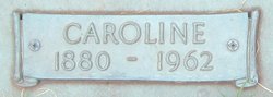
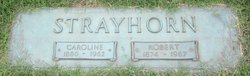
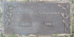
Caroline R “Carrie” Bell Strayhorn
| Birth | : | 30 Jan 1880 Orange County, North Carolina, USA |
| Death | : | 24 Aug 1962 Spencer, Rowan County, North Carolina, USA |
| Burial | : | Rowan Memorial Park Cemetery, Salisbury, Rowan County, USA |
| Coordinate | : | 35.7178001, -80.4955978 |
| Plot | : | Singing Tower, Section B |
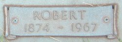
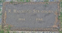
| Description | : | Daughter of Benjamin Hardesty Bell and Caroline Vincent Berry Bell. Married to Robert Harris Strayhorn on April 30, 1913 in Guilford County, North Carolina. Robert and Caroline were the parents of: Robert Hammond Strayhorn Carrie Bell Strayhorn George Vincent Strayhorne ****************************** 1910 United States Federal Census Name: Carrie R Bell Age in 1910: 30 Birth Year: 1880 Birthplace: North Carolina Home in 1910: Eno, Orange, North Carolina Race: White Gender: Female Relation to Head of House: Daughter Marital Status: Single Father's Birthplace: North Carolina Mother's Name: Caroline Bell Mother's Birthplace: North Carolina Household Members: Name Age Caroline Bell 65 Carrie R Bell 30 Mawah Benn 67 Gertrude Bell... Read More |
frequently asked questions (FAQ):
-
Where is Caroline R “Carrie” Bell Strayhorn's memorial?
Caroline R “Carrie” Bell Strayhorn's memorial is located at: Rowan Memorial Park Cemetery, Salisbury, Rowan County, USA.
-
When did Caroline R “Carrie” Bell Strayhorn death?
Caroline R “Carrie” Bell Strayhorn death on 24 Aug 1962 in Spencer, Rowan County, North Carolina, USA
-
Where are the coordinates of the Caroline R “Carrie” Bell Strayhorn's memorial?
Latitude: 35.7178001
Longitude: -80.4955978
Family Members:
Parent
Spouse
Siblings
Children

Flowers:


Nearby Cemetories:
1. Rowan Memorial Park Cemetery
Salisbury, Rowan County, USA
Coordinate: 35.7178001, -80.4955978
2. Bethel Lutheran Church Cemetery
Franklin, Rowan County, USA
Coordinate: 35.7212500, -80.4909410
3. Franklin Presbyterian Church Cemetery
Franklin, Rowan County, USA
Coordinate: 35.7246880, -80.5032580
4. Sacred Heart Roman Catholic Cemetery
Salisbury, Rowan County, USA
Coordinate: 35.7077500, -80.5074440
5. Old Lebanon Methodist Church Cemetery
Salisbury, Rowan County, USA
Coordinate: 35.7248800, -80.4752750
6. Gloria Dei Lutheran Church Columbarium
Salisbury, Rowan County, USA
Coordinate: 35.6938358, -80.5110054
7. Enon Baptist Church Cemetery
Salisbury, Rowan County, USA
Coordinate: 35.7082291, -80.5275421
8. Ardis Chapel AME Zion Church Cemetery
Salisbury, Rowan County, USA
Coordinate: 35.7038918, -80.4660721
9. Calvary Baptist Church Cemetery
Salisbury, Rowan County, USA
Coordinate: 35.7240510, -80.4600340
10. Mount Tabor United Methodist Church Cemetery
Salisbury, Rowan County, USA
Coordinate: 35.7406520, -80.4718440
11. Salisbury National Cemetery Annex
Salisbury, Rowan County, USA
Coordinate: 35.6879710, -80.4912790
12. Second Creek AME Zion - New Birth of Christ Church
Franklin Township, Rowan County, USA
Coordinate: 35.7461100, -80.5252800
13. Oakwood Cemetery
Salisbury, Rowan County, USA
Coordinate: 35.6789040, -80.4985750
14. Memorial Park Cemetery
Salisbury, Rowan County, USA
Coordinate: 35.6784680, -80.4800140
15. Oakdale Union Hill Cemetery
Salisbury, Rowan County, USA
Coordinate: 35.6763130, -80.4905630
16. Second Creek AME Zion Cemetery
Franklin, Rowan County, USA
Coordinate: 35.7572189, -80.5209352
17. Owens Cemetery
Franklin, Rowan County, USA
Coordinate: 35.7581730, -80.5205010
18. The Arbor United Methodist Church Cemetery
Salisbury, Rowan County, USA
Coordinate: 35.7356700, -80.5509200
19. Saint Matthew's Episcopal Church Cemetery
Salisbury, Rowan County, USA
Coordinate: 35.7058983, -80.5554962
20. First Baptist Church of Salisbury Columbarium
Salisbury, Rowan County, USA
Coordinate: 35.6710000, -80.4710400
21. Old English Cemetery
Salisbury, Rowan County, USA
Coordinate: 35.6699982, -80.4697037
22. Presbyterian Session House Burial Ground
Salisbury, Rowan County, USA
Coordinate: 35.6690550, -80.4720260
23. Oak Grove Freedman's Cemetery
Salisbury, Rowan County, USA
Coordinate: 35.6697700, -80.4693000
24. Saint John's Lutheran Columbarium and Garden
Salisbury, Rowan County, USA
Coordinate: 35.6688340, -80.4715850