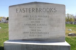
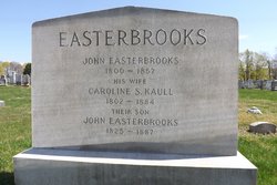
| Birth | : | 1832 Rhode Island, USA |
| Death | : | 16 Feb 1920 Providence, Providence County, Rhode Island, USA |
| Burial | : | Grace Church Cemetery, Providence, Providence County, USA |
| Coordinate | : | 41.8112793, -71.4222565 |
| Description | : | death record from familysearch: from Rhode Island Deaths and Burials Name Caroline Smith Mathews Gender Female Death Date 16 Feb 1920 Death Place Providence, Providence, Rhode Island Age 87 Birth Date 1833 Marital Status Married Spouse's Name A. Judson Mathews Father's Name John Easterbrooks Mother's Name Caroline Easterbrooks living in Providence in 1920 federal census: Carry S Mathews Head F 69* Rhode Island Lenora V Mathews Daughter F 41 Rhode Island *error 1915 State of Rhode Island census: Mathews, Carrie, head, 82 Mathews, Nora, daughter, 35 widowed, she was living in Providence in 1910: Caroline M Mathews Head F 77 Rhode Island Leonora V Mathews Daughter F 48 Rhode Island living in Providence in 1860, with several servants and boarders - her... Read More |
frequently asked questions (FAQ):
-
Where is Caroline Smith “Carrie” Easterbrooks Mathews's memorial?
Caroline Smith “Carrie” Easterbrooks Mathews's memorial is located at: Grace Church Cemetery, Providence, Providence County, USA.
-
When did Caroline Smith “Carrie” Easterbrooks Mathews death?
Caroline Smith “Carrie” Easterbrooks Mathews death on 16 Feb 1920 in Providence, Providence County, Rhode Island, USA
-
Where are the coordinates of the Caroline Smith “Carrie” Easterbrooks Mathews's memorial?
Latitude: 41.8112793
Longitude: -71.4222565
Family Members:
Parent
Spouse
Siblings
Children
Flowers:
Nearby Cemetories:
1. Grace Church Cemetery
Providence, Providence County, USA
Coordinate: 41.8112793, -71.4222565
2. Captain Richard Hoyle Lot (Defunct)
Providence, Providence County, USA
Coordinate: 41.8051150, -71.4198730
3. Old Burial Ground
Providence, Providence County, USA
Coordinate: 41.8048060, -71.4196410
4. West Burial Ground (Defunct)
Providence, Providence County, USA
Coordinate: 41.8161920, -71.4143700
5. Cathedral of Saints Peter and Paul
Providence, Providence County, USA
Coordinate: 41.8188900, -71.4163700
6. First Congregational Society Cemetery (Defunct)
Providence, Providence County, USA
Coordinate: 41.8200960, -71.4141780
7. Locust Grove Cemetery
Providence, Providence County, USA
Coordinate: 41.7997017, -71.4263992
8. Sayles-Payne Lot
Providence, Providence County, USA
Coordinate: 41.7979740, -71.4293630
9. James Harris Lot
Cranston, Providence County, USA
Coordinate: 41.8029870, -71.4395230
10. Resolved Waterman Lot
Johnston, Providence County, USA
Coordinate: 41.8165090, -71.4448440
11. Tillinghast Lot
Providence, Providence County, USA
Coordinate: 41.8205109, -71.4019928
12. Plain Farm Burying Ground (Defunct)
Providence, Providence County, USA
Coordinate: 41.8086780, -71.4479800
13. Governor Nicholas Cooke Lot (Defunct)
Providence, Providence County, USA
Coordinate: 41.8205880, -71.3992760
14. Annmary Brown Memorial
Providence, Providence County, USA
Coordinate: 41.8243000, -71.4025800
15. Captain John Pitcher Lot
Cranston, Providence County, USA
Coordinate: 41.7998000, -71.4444000
16. Roger Williams Burial Ground (Defunct)
Providence, Providence County, USA
Coordinate: 41.8302540, -71.4108870
17. Wamsley Lot
Providence, Providence County, USA
Coordinate: 41.7929720, -71.4078750
18. Colonel Richard Fenner Lot (Defunct)
Cranston, Providence County, USA
Coordinate: 41.7975890, -71.4443760
19. Roger Williams Memorial
Providence, Providence County, USA
Coordinate: 41.8298607, -71.4072189
20. Arnold-Tillinghast Burial Ground (Defunct)
Providence, Providence County, USA
Coordinate: 41.8218700, -71.3965980
21. Saint Johns Cemetery
Providence, Providence County, USA
Coordinate: 41.8313065, -71.4099197
22. Prospect Terrace Park
Providence, Providence County, USA
Coordinate: 41.8308060, -71.4070350
23. Waterman Lot (Defunct)
Providence, Providence County, USA
Coordinate: 41.8219670, -71.4499290
24. Charles Brown Lot (Defunct)
Cranston, Providence County, USA
Coordinate: 41.8104610, -71.4541130


