
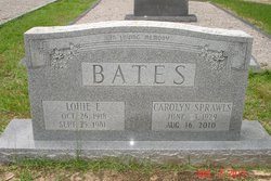

Carolyn Sprawls Bates
| Birth | : | 23 Jun 1927 South Carolina, USA |
| Death | : | 16 Aug 2010 Branchville, Orangeburg County, South Carolina, USA |
| Burial | : | Portage Central Cemetery, Portage, Kalamazoo County, USA |
| Coordinate | : | 42.2041790, -85.5891560 |
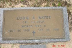
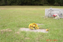
| Description | : | August 18, 2010 Times and Democrat Mrs. Carolyn Sprawls Bates, 81, of Branchville, died Monday, Aug. 16, 2010. Mrs. Bates was born in Barnwell County, a daughter of the late Walton Sprawls and Ruth Weathersbee Sprawls. She was a member of Mount Tabor Baptist Church, was the widow of the late Louie E. Bates, and made her home in Branchville for more than 60 years. Graveside services will be conducted at 3 p.m. Wednesday, Aug. 18, at Ott Cemetery in Branchville, with the Rev. Brian Gray officiating. The family will receive friends one hour before services at Ott Funeral... Read More |
frequently asked questions (FAQ):
-
Where is Carolyn Sprawls Bates's memorial?
Carolyn Sprawls Bates's memorial is located at: Portage Central Cemetery, Portage, Kalamazoo County, USA.
-
When did Carolyn Sprawls Bates death?
Carolyn Sprawls Bates death on 16 Aug 2010 in Branchville, Orangeburg County, South Carolina, USA
-
Where are the coordinates of the Carolyn Sprawls Bates's memorial?
Latitude: 42.2041790
Longitude: -85.5891560
Family Members:
Parent
Spouse
Siblings

Children
Flowers:


Nearby Cemetories:
1. Portage Central Cemetery
Portage, Kalamazoo County, USA
Coordinate: 42.2041790, -85.5891560
2. Pathfinder Church Memory Garden
Portage, Kalamazoo County, USA
Coordinate: 42.1877397, -85.5898254
3. West Street Cemetery
Kalamazoo, Kalamazoo County, USA
Coordinate: 42.1856030, -85.5902340
4. Dry Prairie Cemetery
Kalamazoo County, USA
Coordinate: 42.2296982, -85.6091995
5. Indian Fields Cemetery
Portage, Kalamazoo County, USA
Coordinate: 42.2305984, -85.5655975
6. South Portage Cemetery
Portage, Kalamazoo County, USA
Coordinate: 42.1668396, -85.5891418
7. Cathedral of Christ the King Resurrection Garden
Portage, Kalamazoo County, USA
Coordinate: 42.2397900, -85.6212600
8. Mount Ever-Rest Memorial Park South
Kalamazoo, Kalamazoo County, USA
Coordinate: 42.2514000, -85.5830994
9. Sand Lake Cemetery
Pavilion Township, Kalamazoo County, USA
Coordinate: 42.1660995, -85.5282974
10. Hope Cemetery
Texas Corners, Kalamazoo County, USA
Coordinate: 42.1939011, -85.6857986
11. Maple Grove Cemetery
Comstock, Kalamazoo County, USA
Coordinate: 42.2630997, -85.5299988
12. Genessee Prairie Cemetery
Oshtemo, Kalamazoo County, USA
Coordinate: 42.2585983, -85.6577988
13. Pioneer Cemetery
Kalamazoo, Kalamazoo County, USA
Coordinate: 42.2808290, -85.5893160
14. Gourdneck Prairie Cemetery
Vicksburg, Kalamazoo County, USA
Coordinate: 42.1264000, -85.5686035
15. Heritage Hall Cornerstone
Kalamazoo, Kalamazoo County, USA
Coordinate: 42.2860230, -85.5970140
16. Saint Lukes Episcopal Church Columbarium
Kalamazoo, Kalamazoo County, USA
Coordinate: 42.2883010, -85.5858860
17. Fellows Family Farm Burial Land
Schoolcraft, Kalamazoo County, USA
Coordinate: 42.1414300, -85.6661100
18. Harrison Cemetery
Schoolcraft, Kalamazoo County, USA
Coordinate: 42.1412600, -85.6664940
19. First Presbyterian Columbarium
Kalamazoo, Kalamazoo County, USA
Coordinate: 42.2896610, -85.5862750
20. Kalamazoo College Stetson Chapel
Kalamazoo, Kalamazoo County, USA
Coordinate: 42.2896000, -85.6012470
21. First United Methodist Church Columbarium
Kalamazoo, Kalamazoo County, USA
Coordinate: 42.2901990, -85.5873420
22. Schoolcraft Township Cemetery
Schoolcraft, Kalamazoo County, USA
Coordinate: 42.1225471, -85.6385117
23. Mountain Home Cemetery
Kalamazoo, Kalamazoo County, USA
Coordinate: 42.2935982, -85.6038971
24. Immanuel Lutheran Church Columbarium
Kalamazoo Township, Kalamazoo County, USA
Coordinate: 42.2961020, -85.6270529