
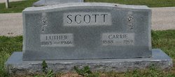
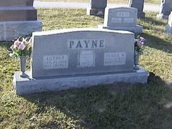
Carrie Lee Payne Scott
| Birth | : | 28 Sep 1888 Enon, Moniteau County, Missouri, USA |
| Death | : | 14 Sep 1969 Jefferson City, Cole County, Missouri, USA |
| Burial | : | Dixon Cemetery, Dixon, Solano County, USA |
| Coordinate | : | 38.4354553, -121.8227005 |
| Plot | : | Section 2 |
| Description | : | Daily Capital News, Jefferson City, Missouri Tuesday, 16 Sep 1969; p. 8 Mrs. Carrie Lee Scott, 81, formerly of Russellville, died Sunday at the Charles E. Still Hospital, Jefferson City. Mrs. Scott was born Sept 28, 1887 [SSDI and tombstone say 1888], near Enon, the daughter of Henry and Cynthia Enloe Payne. She was married Dec 24, 1908 to Luther [Charles Luther] Scott, who died in 1946. Survivors include: Three daughters, Mrs. J. K. Scott, Centralia, Mrs. J. E. Bernard, Stillwell, Kan., Mrs. Carl Morrow, Jefferson City; one son, Paul Scott, Jefferson City; seven grandchildren and 14 great-grandchildren. Services will be held at 2 pm... Read More |
frequently asked questions (FAQ):
-
Where is Carrie Lee Payne Scott's memorial?
Carrie Lee Payne Scott's memorial is located at: Dixon Cemetery, Dixon, Solano County, USA.
-
When did Carrie Lee Payne Scott death?
Carrie Lee Payne Scott death on 14 Sep 1969 in Jefferson City, Cole County, Missouri, USA
-
Where are the coordinates of the Carrie Lee Payne Scott's memorial?
Latitude: 38.4354553
Longitude: -121.8227005
Family Members:
Parent
Spouse

Siblings
Flowers:


Nearby Cemetories:
1. Dixon Cemetery
Dixon, Solano County, USA
Coordinate: 38.4354553, -121.8227005
2. Sacramento Valley National Cemetery
Dixon, Solano County, USA
Coordinate: 38.4167800, -121.8754000
3. Binghampton Cemetery
Solano County, USA
Coordinate: 38.3510550, -121.8244220
4. Tremont Cemetery
Dixon, Solano County, USA
Coordinate: 38.4940987, -121.7043991
5. Episcopal Church of Saint Martin Columbarium
Davis, Yolo County, USA
Coordinate: 38.5488870, -121.7611850
6. Vacaville-Elmira Cemetery
Vacaville, Solano County, USA
Coordinate: 38.3517570, -121.9634933
7. Davis Cemetery
Davis, Yolo County, USA
Coordinate: 38.5550003, -121.7260971
8. Winters Cemetery
Winters, Yolo County, USA
Coordinate: 38.5256004, -121.9777985
9. Pioneer Cemetery at Pena Adobe
Vacaville, Solano County, USA
Coordinate: 38.3389200, -122.0127200
10. Old County Hospital Cemetery
Fairfield, Solano County, USA
Coordinate: 38.2659190, -122.0135510
11. Saint Joseph Cemetery
Woodland, Yolo County, USA
Coordinate: 38.6694400, -121.7842120
12. Woodland Cemetery
Woodland, Yolo County, USA
Coordinate: 38.6711006, -121.7846985
13. Corbin Cemetery
Esparto, Yolo County, USA
Coordinate: 38.6240710, -122.0105040
14. Fairmont Memorial Park
Fairfield, Solano County, USA
Coordinate: 38.2648040, -122.0411970
15. Cottonwood Cemetery
Winters, Yolo County, USA
Coordinate: 38.6500015, -121.9677963
16. Saint Alphonsus Catholic Cemetery
Fairfield, Solano County, USA
Coordinate: 38.2620546, -122.0410961
17. Suisun-Fairfield Cemetery
Fairfield, Solano County, USA
Coordinate: 38.2613678, -122.0405960
18. Monument Hill Memorial Park
Woodland, Yolo County, USA
Coordinate: 38.6781020, -121.8566400
19. Wragg Canyon Cemetery
Napa County, USA
Coordinate: 38.4680220, -122.1562050
20. Gordon Family Cemetery
Esparto, Yolo County, USA
Coordinate: 38.6966060, -121.9151540
21. Shiloh Cemetery
Birds Landing, Solano County, USA
Coordinate: 38.1685310, -121.8893440
22. Sunset Hill Cemetery
Sacramento, Sacramento County, USA
Coordinate: 38.5608000, -121.5037300
23. Masonic Lawn Cemetery
Sacramento, Sacramento County, USA
Coordinate: 38.5604720, -121.5032600
24. Odd Fellows Lawn Cemetery and Mausoleum
Sacramento, Sacramento County, USA
Coordinate: 38.5585000, -121.5011000