
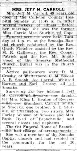
Carrie Mae Sturkie Carroll
| Birth | : | 25 Apr 1899 Orangeburg County, South Carolina, USA |
| Death | : | 3 Apr 1949 Smoaks, Colleton County, South Carolina, USA |
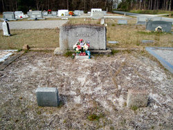
| Burial | : | Oakwood Cemetery, Allegan, Allegan County, USA |
| Coordinate | : | 42.5269012, -85.8638992 |
frequently asked questions (FAQ):
-
Where is Carrie Mae Sturkie Carroll's memorial?
Carrie Mae Sturkie Carroll's memorial is located at: Oakwood Cemetery, Allegan, Allegan County, USA.
-
When did Carrie Mae Sturkie Carroll death?
Carrie Mae Sturkie Carroll death on 3 Apr 1949 in Smoaks, Colleton County, South Carolina, USA
-
Where are the coordinates of the Carrie Mae Sturkie Carroll's memorial?
Latitude: 42.5269012
Longitude: -85.8638992
Family Members:
Parent

Spouse
Siblings
Children
Flowers:


Nearby Cemetories:
1. Oakwood Cemetery
Allegan, Allegan County, USA
Coordinate: 42.5269012, -85.8638992
2. Blessed Sacrament Catholic Church Cemetery
Allegan, Allegan County, USA
Coordinate: 42.5281800, -85.8626170
3. Hudson Corners Cemetery
Allegan, Allegan County, USA
Coordinate: 42.5500000, -85.8366660
4. Mallory Cemetery
Allegan, Allegan County, USA
Coordinate: 42.4857979, -85.8577271
5. Jewett Cemetery
South Monterey, Allegan County, USA
Coordinate: 42.5792007, -85.8735962
6. Allegan County Poor Farm Cemetery
Allegan, Allegan County, USA
Coordinate: 42.5809890, -85.8691040
7. Blackman Cemetery
Allegan, Allegan County, USA
Coordinate: 42.5035100, -85.7890900
8. Millgrove Cemetery
Allegan, Allegan County, USA
Coordinate: 42.5722220, -85.9177770
9. Rowe Cemetery
Chicora, Allegan County, USA
Coordinate: 42.4942017, -85.9555969
10. Immanuel Lutheran Cemetery
Allegan, Allegan County, USA
Coordinate: 42.5210991, -85.7619019
11. Poplar Hill Cemetery
Monterey Township, Allegan County, USA
Coordinate: 42.6161003, -85.8416977
12. Miner Cemetery
Martin, Allegan County, USA
Coordinate: 42.5497017, -85.7422028
13. Trowbridge Methodist Cemetery
Trowbridge Township, Allegan County, USA
Coordinate: 42.4464510, -85.7984160
14. Lindsley Cemetery
Cheshire Center, Allegan County, USA
Coordinate: 42.4510117, -85.9454880
15. Sacred Heart Cemetery
Watson Township, Allegan County, USA
Coordinate: 42.5691300, -85.7417460
16. Brookside Cemetery
Dunningville, Allegan County, USA
Coordinate: 42.6133003, -85.9567032
17. Indian Cemetery
Cheshire Center, Allegan County, USA
Coordinate: 42.4483337, -85.9741669
18. Pine Creek Cemetery
Otsego, Allegan County, USA
Coordinate: 42.4555560, -85.7305560
19. Saint Pauls Evangelical Lutheran Cemetery
Hopkins, Allegan County, USA
Coordinate: 42.6317960, -85.7805200
20. Baseline Cemetery
Cheshire Center, Allegan County, USA
Coordinate: 42.4200000, -85.9488880
21. Pearson Cemetery
Cheshire Township, Allegan County, USA
Coordinate: 42.4474983, -85.9978027
22. Valley Township Cemetery
Fennville, Allegan County, USA
Coordinate: 42.5863808, -86.0158280
23. Earl Cemetery
Kendall, Van Buren County, USA
Coordinate: 42.3960000, -85.8250000
24. Hicks Cemetery
Watson Township, Allegan County, USA
Coordinate: 42.5438995, -85.6808014