

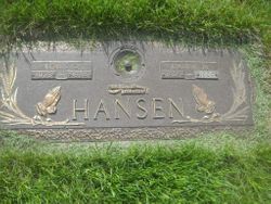

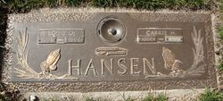
Carrie Marie Holmberg Hansen
| Birth | : | 23 Apr 1906 Ayrshire, Palo Alto County, Iowa, USA |
| Death | : | 20 Oct 1999 Spencer, Clay County, Iowa, USA |
| Burial | : | North Lawn Cemetery, Spencer, Clay County, USA |
| Coordinate | : | 43.1600000, -95.1470000 |
| Description | : | Carrie Hansen, 93, passed away Wednesday, October 20, 1999 at Longhouse Residence in Spencer. Funeral services will be 1:30 p.m., Saturday, October 23 at Warner Chapel in Spencer with the Rev. Lanny Carlson officiating. Casket Bearers; Randy Hansen, Curt Hansen, Terry Hansen, Lanny Hanson, Dave Kause and Rick Hall Burial will be at North Lawn Memorial Park in Spencer. Warner Funeral Home of Spencer is in charge of the arrangements. Carrie Marie Hansen, daughter of Hans and Lena Hanson Holmberg, was born April 23, 1906 in Ayrshire. Her childhood years were spent in the Dickens area, where she received... Read More |
frequently asked questions (FAQ):
-
Where is Carrie Marie Holmberg Hansen's memorial?
Carrie Marie Holmberg Hansen's memorial is located at: North Lawn Cemetery, Spencer, Clay County, USA.
-
When did Carrie Marie Holmberg Hansen death?
Carrie Marie Holmberg Hansen death on 20 Oct 1999 in Spencer, Clay County, Iowa, USA
-
Where are the coordinates of the Carrie Marie Holmberg Hansen's memorial?
Latitude: 43.1600000
Longitude: -95.1470000
Family Members:
Spouse
Flowers:


Nearby Cemetories:
1. North Lawn Cemetery
Spencer, Clay County, USA
Coordinate: 43.1600000, -95.1470000
2. Dewey Readmore Books Memorial
Spencer, Clay County, USA
Coordinate: 43.1403999, -95.1443024
3. Riverside Cemetery
Spencer, Clay County, USA
Coordinate: 43.1441994, -95.1671982
4. Fairview Cemetery
Clay County, USA
Coordinate: 43.1899986, -95.0800018
5. Evergreen Cemetery
Clay County, USA
Coordinate: 43.2052994, -95.2086029
6. Dickens Cemetery
Dickens, Clay County, USA
Coordinate: 43.1280000, -95.0155000
7. Swedish Lutheran Cemetery
Royal, Clay County, USA
Coordinate: 43.0683000, -95.2350000
8. Little Sioux Lutheran Cemetery
Milford, Dickinson County, USA
Coordinate: 43.2702065, -95.2109528
9. Rosehill Cemetery
Clay County, USA
Coordinate: 43.0368996, -95.0919037
10. First Reformed Cemetery
Clay County, USA
Coordinate: 43.2399500, -95.2889000
11. Lone Tree Cemetery
Everly, Clay County, USA
Coordinate: 43.1411018, -95.3347015
12. Milford Cemetery
Milford, Dickinson County, USA
Coordinate: 43.3092003, -95.1481018
13. Lincoln Cemetery
Rossie, Clay County, USA
Coordinate: 43.0111008, -95.2313995
14. Calvary Cemetery
Milford, Dickinson County, USA
Coordinate: 43.3213997, -95.1688995
15. Logan Township Cemetery
Clay County, USA
Coordinate: 43.0489006, -94.9747009
16. Liberty Cemetery
Greenville, Clay County, USA
Coordinate: 42.9897003, -95.1417007
17. Willow Creek Cemetery
Royal, Clay County, USA
Coordinate: 43.0214005, -95.2885971
18. Clay Center Cemetery
Royal, Clay County, USA
Coordinate: 43.0410995, -95.3272018
19. TriMello Cemetery
Royal, Clay County, USA
Coordinate: 43.0682983, -95.3728027
20. Crown Hill Cemetery
Ruthven, Palo Alto County, USA
Coordinate: 43.1328011, -94.8878021
21. Calvary Cemetery
Ruthven, Palo Alto County, USA
Coordinate: 43.1314011, -94.8869019
22. Zion Methodist Cemetery
Clay County, USA
Coordinate: 42.9808006, -95.2497025
23. Westport Cemetery
Dickinson County, USA
Coordinate: 43.3130989, -95.3289032
24. Okoboji Cemetery
Arnolds Park, Dickinson County, USA
Coordinate: 43.3649406, -95.1303558