

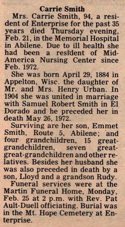
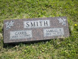
Carrie Urban Smith
| Birth | : | 29 Apr 1885 Appleton, Outagamie County, Wisconsin, USA |
| Death | : | 21 Feb 1980 Abilene, Dickinson County, Kansas, USA |
| Burial | : | Mount Hope Cemetery, Enterprise, Dickinson County, USA |
| Coordinate | : | 38.8869019, -97.1121979 |
| Plot | : | I-32. |
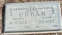
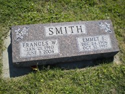
| Description | : | RC undated clippings in DCHS; born 29 April 1885, Appleton, Wisconsin; daughter of Mr. & Mrs. Henry Urban; married 1904 at El Dorado to Samuel Robert Smith who died 1972; had 2 sons; moved to Enterprise 35 years ago; died 21 Feb 1980 in Abilene hospital; survived by 1 son Emmett of rural Abilene; 4 grandchildren; 15 great-grandchildren; 7 great-great-grandchildren; preceded by 1 son Lloyd and 1 grandson Rudy. ****** Carrie Urban United States Census, 1900 Name Carrie Urban Event Type Census Event Year 1900 Event Place Salt River Township (west part excl. Shelbina city), Shelby, Missouri, United States Gender Female Age 15 Marital Status Single Race White Race (Original) W Relationship to... Read More |
frequently asked questions (FAQ):
-
Where is Carrie Urban Smith's memorial?
Carrie Urban Smith's memorial is located at: Mount Hope Cemetery, Enterprise, Dickinson County, USA.
-
When did Carrie Urban Smith death?
Carrie Urban Smith death on 21 Feb 1980 in Abilene, Dickinson County, Kansas, USA
-
Where are the coordinates of the Carrie Urban Smith's memorial?
Latitude: 38.8869019
Longitude: -97.1121979
Family Members:
Parent

Spouse
Children
Flowers:


Nearby Cemetories:
1. Mount Hope Cemetery
Enterprise, Dickinson County, USA
Coordinate: 38.8869019, -97.1121979
2. Scheiller Cemetery
Enterprise, Dickinson County, USA
Coordinate: 38.8669014, -97.1106033
3. Pleasant Hill Cemetery
Enterprise, Dickinson County, USA
Coordinate: 38.8885150, -97.0749560
4. Lutheran Cemetery #17
Enterprise, Dickinson County, USA
Coordinate: 38.9009209, -97.0734787
5. Detroit Cemetery
Detroit, Dickinson County, USA
Coordinate: 38.9439300, -97.1255100
6. Farmington Cemetery
Abilene, Dickinson County, USA
Coordinate: 38.8707800, -97.1860200
7. Brown Memorial Cemetery
Abilene, Dickinson County, USA
Coordinate: 38.8755950, -97.1993410
8. Eisenhower Presidential Library and Museum Chapel
Abilene, Dickinson County, USA
Coordinate: 38.9118450, -97.2129410
9. Saint John's Episcopal Church Memorial Garden
Abilene, Dickinson County, USA
Coordinate: 38.9202700, -97.2137300
10. Dwight D. Eisenhower Municipal Building
Abilene, Dickinson County, USA
Coordinate: 38.9191100, -97.2155700
11. Navarre Cemetery
Navarre, Dickinson County, USA
Coordinate: 38.7957115, -97.1080627
12. Riffel Cemetery (Defunct)
Woodbine, Dickinson County, USA
Coordinate: 38.8177986, -97.0342026
13. Abilene Cemetery
Abilene, Dickinson County, USA
Coordinate: 38.9322014, -97.2217026
14. Belle Springs Cemetery
Hope, Dickinson County, USA
Coordinate: 38.7907982, -97.1481018
15. Mount Saint Joseph Cemetery
Abilene, Dickinson County, USA
Coordinate: 38.9442170, -97.2218690
16. Indian Hill Cemetery
Chapman, Dickinson County, USA
Coordinate: 38.9714012, -97.0327988
17. Bethel Cemetery
Moonlight, Dickinson County, USA
Coordinate: 39.0022011, -97.1110535
18. Rinehart Cemetery
Enterprise, Dickinson County, USA
Coordinate: 38.9021988, -96.9638977
19. Saint Patricks Cemetery
Chapman, Dickinson County, USA
Coordinate: 38.9803330, -97.0062850
20. Newbern Cemetery
Holland, Dickinson County, USA
Coordinate: 38.8133011, -97.2427979
21. Ebenezer Baptist Cemetery
Dickinson County, USA
Coordinate: 38.7659569, -97.1696701
22. Langhofer Cemetery
Woodbine, Dickinson County, USA
Coordinate: 38.7905530, -96.9921110
23. Langhofer-Riffel Cemetery
Woodbine, Dickinson County, USA
Coordinate: 38.7835530, -96.9874660
24. Mount Zion Cemetery
Junction City, Geary County, USA
Coordinate: 38.8762000, -96.9267080