
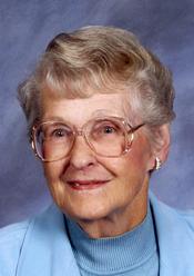

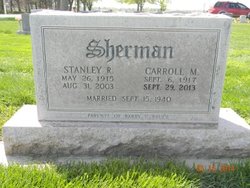
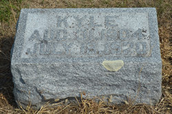
Carroll M. Berry Sherman
| Birth | : | 6 Sep 1917 Dayton, Webster County, Iowa, USA |
| Death | : | 29 Sep 2013 Kearney, Buffalo County, Nebraska, USA |
| Burial | : | Greenwood Cemetery, Lexington, Dawson County, USA |
| Coordinate | : | 40.7956467, -99.7286682 |
| Plot | : | DIV. A, BLOCK 37, LOT 3, SPACE 2. |
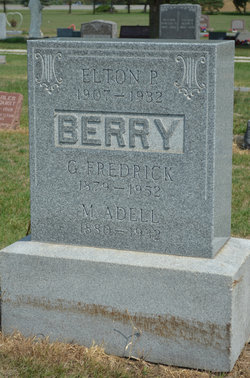
| Description | : | Carroll M. Sherman, 96, of Kearney, Nebraska, former Lexington resident, passed away Sunday, September 29, 2013, at Mother Hull Home in Kearney. She was born September 6, 1917, in Dayton, Iowa, to G.F. and M. Adell (Draper) Berry. She was a 1936 graduate of Gilbert High School in Gilbert, Iowa. Carroll worked as a nanny for 2 years in Iowa prior to moving to Lexington in 1939. When she moved to Lexington she worked for a year at the Lexington Community Hospital. Carroll was married to Stanley Sherman on September 15, 1940, in Lexington. Two sons were blessed to this... Read More |
frequently asked questions (FAQ):
-
Where is Carroll M. Berry Sherman's memorial?
Carroll M. Berry Sherman's memorial is located at: Greenwood Cemetery, Lexington, Dawson County, USA.
-
When did Carroll M. Berry Sherman death?
Carroll M. Berry Sherman death on 29 Sep 2013 in Kearney, Buffalo County, Nebraska, USA
-
Where are the coordinates of the Carroll M. Berry Sherman's memorial?
Latitude: 40.7956467
Longitude: -99.7286682
Family Members:
Parent

Spouse
Siblings

Children

Flowers:


Nearby Cemetories:
1. First United Methodist Church Columbarium
Lexington, Dawson County, USA
Coordinate: 40.7810000, -99.7397000
2. Saint Anns Cemetery
Lexington, Dawson County, USA
Coordinate: 40.7789001, -99.7114029
3. Evergreen Cemetery
Lexington, Dawson County, USA
Coordinate: 40.7639008, -99.6791992
4. Mount Hope Cemetery
Dawson County, USA
Coordinate: 40.8293991, -99.6733017
5. Hewitt Cemetery
Lexington, Dawson County, USA
Coordinate: 40.8588982, -99.7769012
6. Buffalo Grove Presbyterian Church Cemetery
Buffalo, Dawson County, USA
Coordinate: 40.8721000, -99.8270000
7. Hillside Cemetery
Dawson County, USA
Coordinate: 40.8946991, -99.7869034
8. Grace Cemetery
Cozad, Dawson County, USA
Coordinate: 40.8602982, -99.8644028
9. Robb Cemetery
Smithfield, Gosper County, USA
Coordinate: 40.6710691, -99.6996001
10. Saint Johns Lutheran Cemetery
Lexington, Dawson County, USA
Coordinate: 40.9019012, -99.8458023
11. Plum Creek Massacre Cemetery
Phelps County, USA
Coordinate: 40.6726840, -99.6058220
12. Overton Cemetery
Overton, Dawson County, USA
Coordinate: 40.7317009, -99.5222015
13. Cozad Cemetery
Cozad, Dawson County, USA
Coordinate: 40.8605995, -99.9475021
14. Quakerville Cemetery
Gosper County, USA
Coordinate: 40.6189003, -99.8097000
15. Cottonwood Cemetery
Dawson County, USA
Coordinate: 40.9322014, -99.9197006
16. Saint Patricks Cemetery
Eddyville, Dawson County, USA
Coordinate: 40.9747009, -99.6093979
17. Adullam Cemetery
Bertrand, Phelps County, USA
Coordinate: 40.6265000, -99.5856000
18. Fairview Cemetery
Dawson County, USA
Coordinate: 40.7719002, -99.9955978
19. Jewell Cemetery
Sumner, Dawson County, USA
Coordinate: 40.9599991, -99.5646973
20. Rose Hill Cemetery
Dawson County, USA
Coordinate: 40.9888992, -99.8442001
21. Elwood Cemetery
Elwood, Gosper County, USA
Coordinate: 40.5999300, -99.8397300
22. Rhinehart Cemetery
Cozad, Dawson County, USA
Coordinate: 40.9599000, -99.9105000
23. Buffalo First Lutheran Cemetery Old
Buffalo, Dawson County, USA
Coordinate: 41.0100000, -99.8152000
24. Buffalo First Lutheran Cemetery New
Buffalo, Dawson County, USA
Coordinate: 41.0127000, -99.8150000