
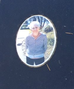
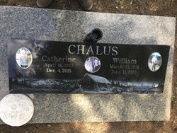

Catherine “Cathy” Chemerys Chalus
| Birth | : | 16 Apr 1933 Bellis, Cold Lake Census Division, Alberta, Canada |
| Death | : | 4 Dec 2015 Invermere, East Kootenay Regional District, British Columbia, Canada |
| Burial | : | Fairmont's Evergreen Cemetery, Fairmont Hot Springs, East Kootenay Regional District, Canada |
| Coordinate | : | 50.3385800, -115.8650300 |
| Inscription | : | The Mountains Shall Bring Peace to the People |
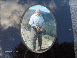
| Description | : | Published in The Columbia Valley Pioneer Catherine Chalus April 16, 1933 ~ December 4, 2015 On Friday, December 4, 2015 we lost an incredible woman, mother, grandmother, great grandmother, friend and the matriarch of our family. Mom passed away peacefully surrounded by her loving family. She was predeceased in 2012 by her husband of fifty-five years, William (Bill) Chalus. She is survived by her four daughters. Also left to cherish Catherine’s memory are eight grandchildren and two great-grandchildren. Catherine was born and raised in Bellis Alberta. She was the youngest of seven children of Anastasia and... Read More |
frequently asked questions (FAQ):
-
Where is Catherine “Cathy” Chemerys Chalus's memorial?
Catherine “Cathy” Chemerys Chalus's memorial is located at: Fairmont's Evergreen Cemetery, Fairmont Hot Springs, East Kootenay Regional District, Canada.
-
When did Catherine “Cathy” Chemerys Chalus death?
Catherine “Cathy” Chemerys Chalus death on 4 Dec 2015 in Invermere, East Kootenay Regional District, British Columbia, Canada
-
Where are the coordinates of the Catherine “Cathy” Chemerys Chalus's memorial?
Latitude: 50.3385800
Longitude: -115.8650300
Family Members:
Parent
Spouse
Siblings

Flowers:


Nearby Cemetories:
1. Fairmont's Evergreen Cemetery
Fairmont Hot Springs, East Kootenay Regional District, Canada
Coordinate: 50.3385800, -115.8650300
2. Windermere District Cemetery
Windermere, East Kootenay Regional District, Canada
Coordinate: 50.4669189, -115.9936600
3. Canal Flats Cemetery
Canal Flats, East Kootenay Regional District, Canada
Coordinate: 50.1617820, -115.8049420
4. Mount View Cemetery
Invermere, East Kootenay Regional District, Canada
Coordinate: 50.5134201, -116.0061951
5. Shuswap First Nations Cemetery
Shuswap, East Kootenay Regional District, Canada
Coordinate: 50.5488800, -116.0308600
6. Radium Hot Springs Columbarium
Radium Hot Springs, East Kootenay Regional District, Canada
Coordinate: 50.6209050, -116.0693980
7. Mountview Cemetery
Elkford, East Kootenay Regional District, Canada
Coordinate: 50.0583600, -114.9222300
8. Kimberley Cemetery
Kimberley, East Kootenay Regional District, Canada
Coordinate: 49.6766700, -115.9746000
9. Argenta Cemetery
Argenta, Central Kootenay Regional District, Canada
Coordinate: 50.1693333, -116.9154333
10. Marysville Cemetery
Marysville, East Kootenay Regional District, Canada
Coordinate: 49.6386900, -115.9513300
11. Fort Steele Cemetery
Fort Steele, East Kootenay Regional District, Canada
Coordinate: 49.6260109, -115.6225662
12. Aqam Cemetery
Cranbrook, East Kootenay Regional District, Canada
Coordinate: 49.5833840, -115.7574800
13. Kaslo Cemetery
Kaslo, Central Kootenay Regional District, Canada
Coordinate: 49.9113100, -116.9329100
14. Canmore Cemetery
Canmore, Canmore Census Division, Canada
Coordinate: 51.0926200, -115.3429400
15. Canmore Old Cemetery
Canmore, Canmore Census Division, Canada
Coordinate: 51.0929000, -115.3416200
16. Cranbrook New General Cemetery
Cranbrook, East Kootenay Regional District, Canada
Coordinate: 49.5118890, -115.7837250
17. Cranbrook Old General Cemetery
Cranbrook, East Kootenay Regional District, Canada
Coordinate: 49.5116630, -115.7826420
18. Cranbrook Catholic Cemetery
Cranbrook, East Kootenay Regional District, Canada
Coordinate: 49.5114080, -115.7813930
19. Westlawn Cemetery
Cranbrook, East Kootenay Regional District, Canada
Coordinate: 49.5112220, -115.7821910
20. Rivercrest Cemetery
Sparwood, East Kootenay Regional District, Canada
Coordinate: 49.7617300, -114.8862200
21. Banff Town Cemetery
Banff, Canmore Census Division, Canada
Coordinate: 51.1739600, -115.5653300
22. Elk Valley Cemetery
Sparwood, East Kootenay Regional District, Canada
Coordinate: 49.7403800, -114.8685100
23. Crawford Bay Cemetery
Crawford Bay, Central Kootenay Regional District, Canada
Coordinate: 49.6945390, -116.8138077
24. Mountain View Cemetery
Banff, Canmore Census Division, Canada
Coordinate: 51.2039490, -115.5351720