
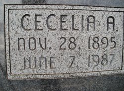

Cecelia Agatha Smith Alders
| Birth | : | 28 Nov 1895 Summerfield, Marshall County, Kansas, USA |
| Death | : | 7 Jun 1987 Marysville, Marshall County, Kansas, USA |
| Burial | : | Saint Josephs Cemetery, Barneston, Gage County, USA |
| Coordinate | : | 40.0653000, -96.5757980 |
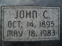
| Description | : | The following information was sent by Sue Shanahan Webb. Parents names were Michael and Catherine. Siblings; Patrick, Nora, Francis, Lizzie, Emmett J., Ambrose Cecelia and John married on April 20, 1920 at Holy Family Church in Summerfield, Kansas. Her son, Clarence always shared that she died on June 2, 1987 and that the cemetery had the wrong death date listed. |
frequently asked questions (FAQ):
-
Where is Cecelia Agatha Smith Alders's memorial?
Cecelia Agatha Smith Alders's memorial is located at: Saint Josephs Cemetery, Barneston, Gage County, USA.
-
When did Cecelia Agatha Smith Alders death?
Cecelia Agatha Smith Alders death on 7 Jun 1987 in Marysville, Marshall County, Kansas, USA
-
Where are the coordinates of the Cecelia Agatha Smith Alders's memorial?
Latitude: 40.0653000
Longitude: -96.5757980
Family Members:
Spouse
Children
Flowers:


Nearby Cemetories:
1. Saint Josephs Cemetery
Barneston, Gage County, USA
Coordinate: 40.0653000, -96.5757980
2. Barneston Cemetery
Barneston, Gage County, USA
Coordinate: 40.0661011, -96.5755997
3. Kinney Cemetery
Gage County, USA
Coordinate: 40.1102100, -96.5588800
4. Saint Johns Cemetery
Barneston, Gage County, USA
Coordinate: 40.0449982, -96.6380997
5. Bethel Cemetery
Wymore, Gage County, USA
Coordinate: 40.0588989, -96.6513977
6. Liberty Cemetery
Liberty, Gage County, USA
Coordinate: 40.0772018, -96.4982986
7. Immanuel Lutheran Cemetery
Wymore, Gage County, USA
Coordinate: 40.0015830, -96.6573720
8. Evangelical Lutheran Cemetery
Liberty, Gage County, USA
Coordinate: 40.0083300, -96.4825100
9. Pleasant Hill Cemetery
Krider, Gage County, USA
Coordinate: 40.0158500, -96.6899400
10. Calvary Cemetery
Wymore, Gage County, USA
Coordinate: 40.1225014, -96.6917038
11. Wymore Cemetery
Wymore, Gage County, USA
Coordinate: 40.1241989, -96.6917038
12. Oketo Cemetery
Oketo, Marshall County, USA
Coordinate: 39.9571991, -96.5950012
13. Blue Springs Cemetery
Blue Springs, Gage County, USA
Coordinate: 40.1526800, -96.6627000
14. Saint Marys Cemetery
Blue Springs, Gage County, USA
Coordinate: 40.1464005, -96.6806030
15. Mission Creek Cemetery
Marshall County, USA
Coordinate: 39.9866982, -96.4649963
16. Pleasant Hill Cemetery
Gage County, USA
Coordinate: 40.1462250, -96.4676820
17. Mission Creek Cemetery
Pawnee County, USA
Coordinate: 40.0149994, -96.4263992
18. North Elm Cemetery
Marshall County, USA
Coordinate: 39.9431000, -96.5325012
19. Tanner Cemetery
Pawnee County, USA
Coordinate: 40.0238991, -96.4143982
20. Stark Cemetery
Holmesville, Gage County, USA
Coordinate: 40.2122002, -96.6147003
21. Brethren Cemetery
Holmesville, Gage County, USA
Coordinate: 40.2125015, -96.6331024
22. Bethlehem Lutheran Cemetery
Bremen, Marshall County, USA
Coordinate: 39.9865500, -96.7500000
23. Virginia Cemetery
Virginia, Gage County, USA
Coordinate: 40.2186012, -96.5117035
24. Saint Josephs Cemetery
Odell, Gage County, USA
Coordinate: 40.0593987, -96.7925034