
| Birth | : | 14 Apr 1936 Indian Valley, Floyd County, Virginia, USA |
| Death | : | 27 Dec 2007 Washington, District of Columbia, District of Columbia, USA |
| Burial | : | Lawnside Cemetery, Woodstown, Salem County, USA |
| Coordinate | : | 39.6483002, -75.3371964 |
| Plot | : | Row M, Lot 30 Upper, Site 2 |
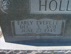
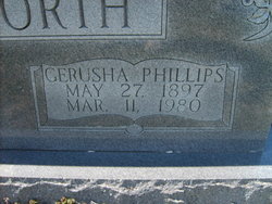
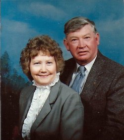
| Description | : | Celesta Sharlene Hollandsworth West, 71, of Poolesville, Md., died on Thursday, December 27, 2007, at the George Washington University Hospital in Washington, D.C., after an extended illness. She was the loving wife of Russell G. West. Born on April 14, 1936, in Indian Valley, Va., she was the daughter of the late Early and Gerusha Phillips Hollandsworth. Sharlene was a lifelong member of the Poolesville Memorial United Methodist Church where she was a greeter, usher and hugger extraordinaire. She participated in the Adult Sunday School class, United Methodist Women's Group, Crafty Ladies and Gents,... Read More |
frequently asked questions (FAQ):
-
Where is Celesta Sharlene Hollandsworth West's memorial?
Celesta Sharlene Hollandsworth West's memorial is located at: Lawnside Cemetery, Woodstown, Salem County, USA.
-
When did Celesta Sharlene Hollandsworth West death?
Celesta Sharlene Hollandsworth West death on 27 Dec 2007 in Washington, District of Columbia, District of Columbia, USA
-
Where are the coordinates of the Celesta Sharlene Hollandsworth West's memorial?
Latitude: 39.6483002
Longitude: -75.3371964
Family Members:
Parent
Spouse

Siblings
Flowers:


Nearby Cemetories:
1. Lawnside Cemetery
Woodstown, Salem County, USA
Coordinate: 39.6483002, -75.3371964
2. Woodstown Friends Burial Ground
Woodstown, Salem County, USA
Coordinate: 39.6505508, -75.3307419
3. Woodstown Baptist Burial Ground
Woodstown, Salem County, USA
Coordinate: 39.6488075, -75.3268127
4. Asbury Methodist Church Cemetery
Woodstown, Salem County, USA
Coordinate: 39.6433372, -75.3272629
5. Woodstown Presbyerian Church Cemetery
Woodstown, Salem County, USA
Coordinate: 39.6485558, -75.3253021
6. Spencer UAME Church Cemetery
Woodstown, Salem County, USA
Coordinate: 39.6414720, -75.3286940
7. Saint Josephs Roman Catholic Church Cemetery
Woodstown, Salem County, USA
Coordinate: 39.6539612, -75.3223419
8. Mount Salem AUMP Church Cemetery
Pilesgrove Township, Salem County, USA
Coordinate: 39.6258580, -75.3422210
9. Salem County Almshouse Cemetery
Mannington, Salem County, USA
Coordinate: 39.6331800, -75.3596000
10. Salem County War Veterans Memorial Park and Cemetery
Woodstown, Salem County, USA
Coordinate: 39.6325111, -75.3612289
11. Sharptown Methodist Church Cemetery
Pilesgrove, Salem County, USA
Coordinate: 39.6559753, -75.3678665
12. Fenwicks Grove
Mannington Township, Salem County, USA
Coordinate: 39.6270300, -75.3712400
13. Mount Zion AME Fenwick Church Cemetery
Portertown, Salem County, USA
Coordinate: 39.6135110, -75.3554600
14. Mount Laurel Church Cemetery
Yorketown, Salem County, USA
Coordinate: 39.6174020, -75.3023530
15. Morning Star Baptist Cemetery
Eldridge Hill, Salem County, USA
Coordinate: 39.6876640, -75.3185501
16. Pilesgrove Methodist Episcopal Cemetery
Pilesgrove, Salem County, USA
Coordinate: 39.6701851, -75.3849869
17. Zion Moravian Church Cemetery
Swedesboro, Gloucester County, USA
Coordinate: 39.7013100, -75.3324600
18. Old Pittsgrove Baptist Churchyard
Upper Pittsgrove, Salem County, USA
Coordinate: 39.6119728, -75.2677689
19. Saint Johns United Methodist Church Cemetery
Harrisonville, Gloucester County, USA
Coordinate: 39.6842500, -75.2666000
20. Ferrell United Methodist Church Cemetery
Harrisonville, Gloucester County, USA
Coordinate: 39.6847725, -75.2669296
21. Jordantown Baptist Church Burial Ground
Auburn, Salem County, USA
Coordinate: 39.7105789, -75.3731232
22. Haines Neck Methodist Church Cemetery
Mannington, Salem County, USA
Coordinate: 39.6532900, -75.4293300
23. Old Pittsgrove Presbyterian Church Cemetery
Daretown, Salem County, USA
Coordinate: 39.5998840, -75.2622986
24. Pittsgrove Presbyterian Church Cemetery
Daretown, Salem County, USA
Coordinate: 39.6009521, -75.2609253