


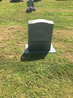
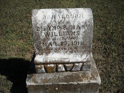
Champ Ferguson Williams
| Birth | : | 12 Apr 1867 Butlers Landing, Clay County, Tennessee, USA |
| Death | : | 24 Jan 1923 Carthage Junction, Smith County, Tennessee, USA |
| Burial | : | IOOF Mountain View Cemetery, Goldendale, Klickitat County, USA |
| Coordinate | : | 45.8304600, -120.8211600 |
| Description | : | Champ Williams was the Sheriff of Clay County Tn.at the time of his death. He was in a car with the Chapman ladies when they had a car wreck and broke his leg, and died later that night from a bood clot. From Feb. 28, 1923 - Tompkinsville, Ky. Champ Williams, Sheriff of Clay County, TN, was killed last night when the automobile he was driving from Nashville was wrecked. Williams was accompanied by Carson Tyler and a squad of revenue men. Tyler was also injured. Sheriff Williams had been persistent in arresting liquor law violators, having captured more... Read More |
frequently asked questions (FAQ):
-
Where is Champ Ferguson Williams's memorial?
Champ Ferguson Williams's memorial is located at: IOOF Mountain View Cemetery, Goldendale, Klickitat County, USA.
-
When did Champ Ferguson Williams death?
Champ Ferguson Williams death on 24 Jan 1923 in Carthage Junction, Smith County, Tennessee, USA
-
Where are the coordinates of the Champ Ferguson Williams's memorial?
Latitude: 45.8304600
Longitude: -120.8211600
Family Members:
Parent
Spouse

Siblings
Children
Flowers:


Nearby Cemetories:
1. IOOF Mountain View Cemetery
Goldendale, Klickitat County, USA
Coordinate: 45.8304600, -120.8211600
2. Holy Trinity Cemetery
Goldendale, Klickitat County, USA
Coordinate: 45.8095000, -120.8486000
3. Woodland Cemetery
Goldendale, Klickitat County, USA
Coordinate: 45.8536600, -120.7893700
4. Spring Creek Cemetery
Goldendale, Klickitat County, USA
Coordinate: 45.8606000, -120.9166000
5. Hugh Caldwell Gravesite
Blockhouse, Klickitat County, USA
Coordinate: 45.8461200, -120.9492400
6. Number 6 Cemetery
Goldendale, Klickitat County, USA
Coordinate: 45.7954300, -120.6878700
7. Centerville Cemetery
Centerville, Klickitat County, USA
Coordinate: 45.7313995, -120.9044037
8. Stonehenge Monument
Maryhill, Klickitat County, USA
Coordinate: 45.6944695, -120.8062973
9. Ghost Horse Family Cemetery
Goldendale, Klickitat County, USA
Coordinate: 45.9100000, -120.9809200
10. Maryhill-Columbus Cemetery
Maryhill, Klickitat County, USA
Coordinate: 45.6928215, -120.8112030
11. Rufus Cemetery
Rufus, Sherman County, USA
Coordinate: 45.6891540, -120.7344410
12. Pleasant Valley Cemetery
Goodnoe Hills, Klickitat County, USA
Coordinate: 45.8310394, -120.5941162
13. White Eagle Memorial Preserve
Goldendale, Klickitat County, USA
Coordinate: 45.8960890, -120.6108330
14. Celilo Indian Cemetery
Wasco County, USA
Coordinate: 45.6502991, -120.9456024
15. Herland Forest Natural Burial Cemetery
Klickitat County, USA
Coordinate: 45.8571990, -121.1202690
16. Seventh Day Adventist Church Cemetery
Wahkiacus, Klickitat County, USA
Coordinate: 45.8665460, -121.1237490
17. Sun Rise Cemetery
Wasco, Sherman County, USA
Coordinate: 45.6068993, -120.7285995
18. Wasco Methodist Cemetery
Wasco, Sherman County, USA
Coordinate: 45.6068993, -120.7264023
19. Crawford Family Cemetery
Glenwood, Klickitat County, USA
Coordinate: 45.6791000, -121.0928300
20. Hartland Cemetery
Klickitat County, USA
Coordinate: 45.7380981, -121.1521988
21. Blackwolf Cemetery
Yakima County, USA
Coordinate: 45.7957900, -120.4649000
22. Farris Cemetery
Klickitat County, USA
Coordinate: 45.7400513, -120.4517899
23. Emigrant Springs Cemetery
Wasco, Sherman County, USA
Coordinate: 45.6193000, -120.5510000
24. Petersburg Cemetery
Wasco County, USA
Coordinate: 45.6094017, -121.0830994