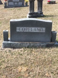
Charles Boles Copeland
| Birth | : | 15 Jan 1871 Herculaneum, Jefferson County, Missouri, USA |
| Death | : | 9 Nov 1933 Dent County, Missouri, USA |
| Burial | : | Bay Cemetery, Timber, Shannon County, USA |
| Coordinate | : | 37.4089012, -91.3103027 |
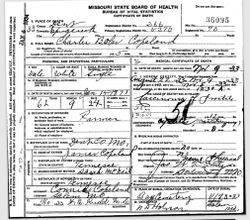
| Description | : | from The Salem (MO) Post and Democrat-Bulletin, Thu, Nov. 9, 1933, page 8: Charley Copeland Dead Charley Copeland, resident at the county farm, died Wednesday night. Funeral services were held this afternoon with burial at the Bay graveyard. His death cert says he died at Spring Creek, Dent, Missouri, USA at 1230a Thursday morning, Nov 9 from prostate cancer. |
frequently asked questions (FAQ):
-
Where is Charles Boles Copeland's memorial?
Charles Boles Copeland's memorial is located at: Bay Cemetery, Timber, Shannon County, USA.
-
When did Charles Boles Copeland death?
Charles Boles Copeland death on 9 Nov 1933 in Dent County, Missouri, USA
-
Where are the coordinates of the Charles Boles Copeland's memorial?
Latitude: 37.4089012
Longitude: -91.3103027
Family Members:
Parent
Siblings
Flowers:
Nearby Cemetories:
1. Bay Cemetery
Timber, Shannon County, USA
Coordinate: 37.4089012, -91.3103027
2. Delmar-Medley-Blake Cemetery
Timber, Shannon County, USA
Coordinate: 37.3889999, -91.3432999
3. Hanning Cemetery
Dent County, USA
Coordinate: 37.4528008, -91.2825012
4. Conway Cemetery
Rat, Shannon County, USA
Coordinate: 37.3692017, -91.2671967
5. Chrisco Cemetery
Timber, Shannon County, USA
Coordinate: 37.3732986, -91.3899994
6. Chatman Cemetery
Dent County, USA
Coordinate: 37.4655991, -91.2525024
7. Gray Cemetery
Dent County, USA
Coordinate: 37.4244003, -91.4044037
8. New Harmony Cemetery
Dent County, USA
Coordinate: 37.3553030, -91.3956720
9. Short Cemetery
Shannondale, Shannon County, USA
Coordinate: 37.3958015, -91.4191971
10. Turner Cemetery
Shannondale, Shannon County, USA
Coordinate: 37.3781013, -91.2007980
11. Heaton Cemetery
Round Spring, Shannon County, USA
Coordinate: 37.3161011, -91.3321991
12. Burnett Cemetery
Rat, Shannon County, USA
Coordinate: 37.3829340, -91.1944630
13. Bunker Cemetery
Bunker, Reynolds County, USA
Coordinate: 37.4543120, -91.2030890
14. Lower Bee Fork Cemetery
Bunker, Reynolds County, USA
Coordinate: 37.4544180, -91.2024880
15. Bedwell Cemetery
Dent County, USA
Coordinate: 37.4439011, -91.4338989
16. Pilgrims Rest North Cemetery
Shannondale, Shannon County, USA
Coordinate: 37.3814011, -91.4372025
17. Scotia Cemetery
Dent County, USA
Coordinate: 37.5200005, -91.3368988
18. Lone Pine Piatt Cemetery
Round Spring, Shannon County, USA
Coordinate: 37.3264008, -91.4085999
19. Brook Cemetery
Dent County, USA
Coordinate: 37.5177994, -91.3531036
20. Parks Cemetery
Bunker, Reynolds County, USA
Coordinate: 37.4735985, -91.1881027
21. Union Hill Cemetery
Round Spring, Shannon County, USA
Coordinate: 37.3139590, -91.4016480
22. Crossville Cemetery
Bunker, Reynolds County, USA
Coordinate: 37.5254800, -91.2341400
23. Estep Cemetery
Reynolds County, USA
Coordinate: 37.4803009, -91.1541977
24. Greeley Cemetery
Bunker, Reynolds County, USA
Coordinate: 37.5145600, -91.1871800

