

Charles “Charley” Romey
| Birth | : | 24 May 1857 Heidelberg, Stadtkreis Heidelberg, Baden-Württemberg, Germany |
| Death | : | 7 Aug 1949 Templeton, Carroll County, Iowa, USA |
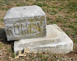
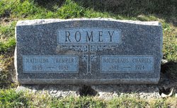
| Burial | : | Sacred Heart Cemetery, Templeton, Carroll County, USA |
| Coordinate | : | 41.9138746, -94.9460994 |
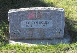
| Description | : | Charley came to the United States when he was seven years old with his mother. They settled in Waterloo, IA and then moved to Independence, IA. At the age of ten, Charley went to Carroll, IA to stay with his uncle, Chris Burke. His mother and step-father, Otto Romey, came to the area two years later. The family settled on a farm south of Templeton and eventually purchased 160 acres in Eden township. Charley married Susanna Langenfeld March 17, 1881 in Roselle at Holy Angels Catholic Church. They raised seven children: Michael, Nicholas, Henry and Joseph (twins), Kathryn, Mary... Read More |
frequently asked questions (FAQ):
-
Where is Charles “Charley” Romey's memorial?
Charles “Charley” Romey's memorial is located at: Sacred Heart Cemetery, Templeton, Carroll County, USA.
-
When did Charles “Charley” Romey death?
Charles “Charley” Romey death on 7 Aug 1949 in Templeton, Carroll County, Iowa, USA
-
Where are the coordinates of the Charles “Charley” Romey's memorial?
Latitude: 41.9138746
Longitude: -94.9460994
Family Members:
Parent
Spouse
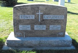
Children

Flowers:


Nearby Cemetories:
1. Sacred Heart Cemetery
Templeton, Carroll County, USA
Coordinate: 41.9138746, -94.9460994
2. Elba Cemetery
Templeton, Carroll County, USA
Coordinate: 41.9068985, -94.9131012
3. Sacred Heart Cemetery
Manning, Carroll County, USA
Coordinate: 41.9132500, -95.0540000
4. Gray Cemetery
Gray, Audubon County, USA
Coordinate: 41.8414001, -94.9946976
5. Manning Cemetery
Manning, Carroll County, USA
Coordinate: 41.8990000, -95.0620000
6. Holy Angels Cemetery
Carroll County, USA
Coordinate: 42.0014000, -94.9141998
7. Cameron Cemetery
Audubon County, USA
Coordinate: 41.8236008, -94.9167023
8. Dedham Cemetery
Dedham, Carroll County, USA
Coordinate: 41.8993988, -94.8225021
9. Saint Josephs Cemetery
Dedham, Carroll County, USA
Coordinate: 41.8993988, -94.8210983
10. Saint Augustine Cemetery
Halbur, Carroll County, USA
Coordinate: 42.0066986, -94.9744034
11. Lincoln Township Cemetery
Gray, Audubon County, USA
Coordinate: 41.8198130, -95.0154970
12. Saint Marys Catholic Cemetery
Willey, Carroll County, USA
Coordinate: 41.9783363, -94.8212204
13. Iowa Township Cemetery
Aspinwall, Crawford County, USA
Coordinate: 41.9216995, -95.1113968
14. McCurdy Cemetery
Carroll County, USA
Coordinate: 41.9403000, -94.7649994
15. Viola Center Cemetery
Viola Center, Audubon County, USA
Coordinate: 41.8236008, -94.8016968
16. Old Carrollton Cemetery
Carrollton, Carroll County, USA
Coordinate: 41.9233017, -94.7403030
17. Mount Olivet Cemetery
Carroll, Carroll County, USA
Coordinate: 42.0536340, -94.8595510
18. Carroll City Cemetery
Carroll, Carroll County, USA
Coordinate: 42.0560963, -94.8599856
19. Hayes Township Cemetery
Westside, Crawford County, USA
Coordinate: 42.0083199, -95.1216583
20. Luccocks Grove Cemetery
Audubon County, USA
Coordinate: 41.7619019, -94.8653030
21. Douglas Township Cemetery
Audubon County, USA
Coordinate: 41.7611008, -95.0282974
22. Oak Hill Cemetery
Coon Rapids, Carroll County, USA
Coordinate: 41.9053001, -94.7200012
23. Westside Cemetery
Westside, Crawford County, USA
Coordinate: 42.0602989, -95.0922012
24. Saint Francis Cemetery
Maple River, Carroll County, USA
Coordinate: 42.0969009, -94.9372025