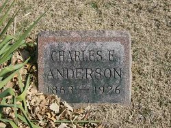
Charles E. Anderson
| Birth | : | 1858 Buchanan County, Missouri, USA |
| Death | : | 1926 Brown County, Kansas, USA |
| Burial | : | Granby Cemetery, Granby, Hartford County, USA |
| Coordinate | : | 41.9571991, -72.7913971 |
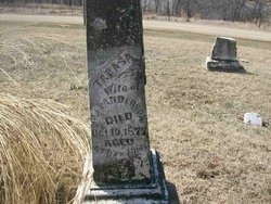
| Description | : | The gravestone has, "1863 - 1926." May 1, 1865 state census. ANDERSON. Irving Twp., Brown Co., KS. Geo., 50, Farmer, b.TN. Teresa, 46, Wife, b.TN. Jerusa O. Hall, 75, Lady, b.N.C. ____, 22, M, Farmer, b.IN. Lovina, 17, Lady, b.IN. Elisha W., 9, b.IN. Chas. E., 6, b.MO. Jno. House, 36, Farm Laborer, b.IN. June 1, 1870 census. ANDERSON. Irwin Twp., Brown Co., KS. Taressa, 50, b.TN. Lavene, 20, b.IN. Elish W., 16, b.IN. Charles E., 12, b.MO. Milly, 3, b.KS. Mar 1, 1875 state census. ANDERSON. Brown Co., KS. Tarasa, 54, b.TN, came to KS from MO. Elisha W., 19, Farmer, b.IN, came to KS from MO. Charles E., 15, b.MO. |
frequently asked questions (FAQ):
-
Where is Charles E. Anderson's memorial?
Charles E. Anderson's memorial is located at: Granby Cemetery, Granby, Hartford County, USA.
-
When did Charles E. Anderson death?
Charles E. Anderson death on 1926 in Brown County, Kansas, USA
-
Where are the coordinates of the Charles E. Anderson's memorial?
Latitude: 41.9571991
Longitude: -72.7913971
Family Members:
Parent
Siblings
Flowers:
Nearby Cemetories:
1. Granby Cemetery
Granby, Hartford County, USA
Coordinate: 41.9571991, -72.7913971
2. The First Church Memorial Garden
Granby, Hartford County, USA
Coordinate: 41.9538918, -72.7891693
3. Pratt Cemetery
Granby, Hartford County, USA
Coordinate: 41.9710999, -72.8143997
4. Holcomb Cemetery
East Granby, Hartford County, USA
Coordinate: 41.9371223, -72.7716751
5. Baptist Cemetery
Granby, Hartford County, USA
Coordinate: 41.9841995, -72.8202972
6. Copper Hill Cemetery
East Granby, Hartford County, USA
Coordinate: 41.9766998, -72.7530975
7. Old Newgate Prison Cemetery
East Granby, Hartford County, USA
Coordinate: 41.9630620, -72.7451570
8. Captain John Viets Cemetery
East Granby, Hartford County, USA
Coordinate: 41.9665909, -72.7455673
9. West Granby Cemetery
Granby, Hartford County, USA
Coordinate: 41.9535522, -72.8400421
10. Congregation Teferes Israel Memorial Park
East Granby, Hartford County, USA
Coordinate: 41.9217300, -72.7715912
11. Beth Hillel Synagogue Memorial Park
East Granby, Hartford County, USA
Coordinate: 41.9218216, -72.7706451
12. Hartford Mutual Society Memorial Park
East Granby, Hartford County, USA
Coordinate: 41.9196815, -72.7742538
13. Spring Cemetery
Granby, Hartford County, USA
Coordinate: 41.9983177, -72.7850494
14. Cooley Cemetery
North Granby, Hartford County, USA
Coordinate: 41.9967003, -72.8127975
15. East Granby Smallpox Cemetery
East Granby, Hartford County, USA
Coordinate: 41.9245000, -72.7491000
16. East Granby Cemetery
East Granby, Hartford County, USA
Coordinate: 41.9416008, -72.7261963
17. Saint Bernard Cemetery
Tariffville, Hartford County, USA
Coordinate: 41.9084282, -72.7686005
18. Tariffville Cemetery
Tariffville, Hartford County, USA
Coordinate: 41.9079132, -72.7694473
19. East Granby Congregational Church Memorial Garden
East Granby, Hartford County, USA
Coordinate: 41.9434330, -72.7239120
20. Mountain Burying Ground
Suffield, Hartford County, USA
Coordinate: 41.9994200, -72.7447500
21. Elmwood Cemetery
East Granby, Hartford County, USA
Coordinate: 41.9371986, -72.7146988
22. Saint Andrew's Episcopal Church Cemetery
Bloomfield, Hartford County, USA
Coordinate: 41.8934593, -72.7584076
23. Merriam Cemetery
North Granby, Hartford County, USA
Coordinate: 42.0181000, -72.8401400
24. Poor Farm Cemetery
Granby, Hartford County, USA
Coordinate: 42.0203180, -72.8416990

