| Birth | : | 1 May 1884 Bear Creek, Outagamie County, Wisconsin, USA |
| Death | : | 27 Oct 1951 Nason Creek, Chelan County, Washington, USA |
| Burial | : | Park Hill Cemetery, Vancouver, Clark County, USA |
| Coordinate | : | 45.6264000, -122.6061020 |
| Plot | : | Section EA, Lot 92, Grave 1 |
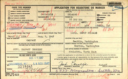
| Description | : | NOTE #1: Four records below, from 1913 to 1942, have his middle name as Edward. Three of those are images of the original records. The only source found that lists his middle name as Edwin is a daughter's birth record, which is transcribed. Plus, Charles had a brother Edwin, so it isn't likely they would use the name twice. NOTE #2: There are three birth places in records for Charles, all in Wisconsin. His mother's 1935 Petition For Citizenship, says Bear Creek, [Outagamie County]. His Social Security Application & Claims and WWII record say Hunting [? County].... Read More |
frequently asked questions (FAQ):
-
Where is Charles Edward Cornagey's memorial?
Charles Edward Cornagey's memorial is located at: Park Hill Cemetery, Vancouver, Clark County, USA.
-
When did Charles Edward Cornagey death?
Charles Edward Cornagey death on 27 Oct 1951 in Nason Creek, Chelan County, Washington, USA
-
Where are the coordinates of the Charles Edward Cornagey's memorial?
Latitude: 45.6264000
Longitude: -122.6061020
Family Members:
Parent
Spouse
Siblings
Children
Flowers:
Nearby Cemetories:
1. Park Hill Cemetery
Vancouver, Clark County, USA
Coordinate: 45.6264000, -122.6061020
2. Old Vancouver City Cemetery
Vancouver, Clark County, USA
Coordinate: 45.6295013, -122.6411972
3. Good Shepherd Episcopal Church Columbarium
Vancouver, Clark County, USA
Coordinate: 45.6153300, -122.5605800
4. Evergreen Memorial Gardens
Vancouver, Clark County, USA
Coordinate: 45.6287500, -122.5568200
5. Mother Joseph Catholic Cemetery
Vancouver, Clark County, USA
Coordinate: 45.6417007, -122.6563034
6. Fort Vancouver Military Cemetery
Vancouver, Clark County, USA
Coordinate: 45.6399950, -122.6598690
7. Saint Lukes Episcopal Church Columbarium
Vancouver, Clark County, USA
Coordinate: 45.6404000, -122.6674000
8. Saint Paul Lutheran Church Memorial Wall
Vancouver, Clark County, USA
Coordinate: 45.6314690, -122.6767370
9. Clark County Poor Farm Cemetery
Vancouver, Clark County, USA
Coordinate: 45.6715240, -122.6527405
10. Oregon Humane Society Animal Cemetery
Portland, Multnomah County, USA
Coordinate: 45.5796900, -122.6527200
11. Historic Columbian Cemetery
Portland, Multnomah County, USA
Coordinate: 45.5843940, -122.6779400
12. Fourth Plain Cemetery
Vancouver, Clark County, USA
Coordinate: 45.6747017, -122.5425034
13. Saint John's Catholic Cemetery
Vancouver, Clark County, USA
Coordinate: 45.7000000, -122.6090000
14. Columbia Masonic Cemetery
Portland, Multnomah County, USA
Coordinate: 45.5587230, -122.5615880
15. Rose City Cemetery
Portland, Multnomah County, USA
Coordinate: 45.5499992, -122.6078033
16. Japanese Ancestral Cemetery
Portland, Multnomah County, USA
Coordinate: 45.5500000, -122.6115000
17. National Sanctuary of Our Sorrowful Mother Cemeter
Portland, Multnomah County, USA
Coordinate: 45.5518690, -122.5721300
18. Fishers Cemetery
Vancouver, Clark County, USA
Coordinate: 45.5891380, -122.5024033
19. Saint Matthews Episcopal Churchyard
Portland, Multnomah County, USA
Coordinate: 45.5555800, -122.5463800
20. Powell Grove Cemetery
Portland, Multnomah County, USA
Coordinate: 45.5567800, -122.5370400
21. Salmon Creek Cemetery
Salmon Creek, Clark County, USA
Coordinate: 45.7043991, -122.6603012
22. Saint Johns Lutheran Cemetery
Salmon Creek, Clark County, USA
Coordinate: 45.7043991, -122.6616974
23. Salmon Creek Pioneer Cemetery
Vancouver, Clark County, USA
Coordinate: 45.7042920, -122.6621647
24. Brush Prairie Cemetery
Brush Prairie, Clark County, USA
Coordinate: 45.7047005, -122.5496979


