
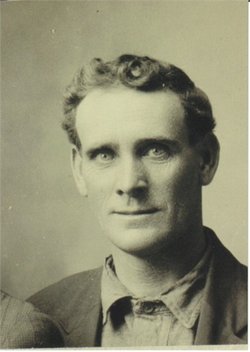
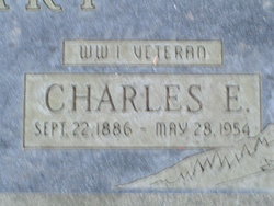
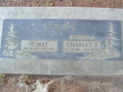
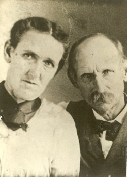
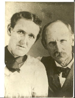
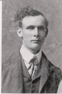
Charles Edward Hart
| Birth | : | 22 Sep 1886 Blue Mound, Linn County, Kansas, USA |
| Death | : | 28 May 1954 Leavenworth, Chelan County, Washington, USA |
| Burial | : | St. Giles' Churchyard, Newcastle-under-Lyme, Newcastle-Under-Lyme Borough, England |
| Coordinate | : | 53.0115110, -2.2301920 |
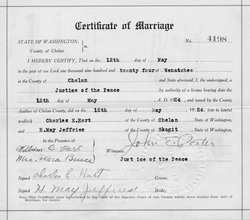
| Description | : | m: 12 May 1924 in Chelan Co, WA Washington Death Certificate Name Charles Edward Hart Death Date 28 May 1954 Death Place Leavenworth, Chelan, Washington Gender Male Age at Death 67 years Estimated Birth Year 1887 Father's Name Columbus Hart Mother's Name Harriet Miller Film Number 2033392 Digital GS Number 4224269 Image Number 1601 Volume/Page/Certificate Number 7909 children: Robert Edward Hart b: 21 Apr 1925 d: 9 Oct 1970, Walter Lee Hart b: 7 Feb 1929 d: 7 Jun 2003 |
frequently asked questions (FAQ):
-
Where is Charles Edward Hart's memorial?
Charles Edward Hart's memorial is located at: St. Giles' Churchyard, Newcastle-under-Lyme, Newcastle-Under-Lyme Borough, England.
-
When did Charles Edward Hart death?
Charles Edward Hart death on 28 May 1954 in Leavenworth, Chelan County, Washington, USA
-
Where are the coordinates of the Charles Edward Hart's memorial?
Latitude: 53.0115110
Longitude: -2.2301920
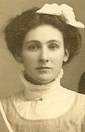
Family Members:
Parent
Spouse
Siblings


Children
Flowers:


Nearby Cemetories:
1. St. Giles' Churchyard
Newcastle-under-Lyme, Newcastle-Under-Lyme Borough, England
Coordinate: 53.0115110, -2.2301920
2. St. George's Churchyard
Newcastle-under-Lyme, Newcastle-Under-Lyme Borough, England
Coordinate: 53.0141190, -2.2242070
3. Newcastle Cemetery
Newcastle-under-Lyme, Newcastle-Under-Lyme Borough, England
Coordinate: 53.0062940, -2.2284440
4. Silverdale Cemetery
Silverdale, Newcastle-Under-Lyme Borough, England
Coordinate: 53.0135400, -2.2559520
5. Newcastle-Under-Lyme Knutton Cemetery
Newcastle-under-Lyme, Newcastle-Under-Lyme Borough, England
Coordinate: 53.0220500, -2.2495100
6. Hartshill Cemetery
Hartshill, Stoke-on-Trent Unitary Authority, England
Coordinate: 53.0054283, -2.2035301
7. St Margaret Churchyard
Wolstanton, Newcastle-Under-Lyme Borough, England
Coordinate: 53.0296810, -2.2154990
8. Etruria Methodist Church
Stoke-on-Trent, Stoke-on-Trent Unitary Authority, England
Coordinate: 53.0209680, -2.1985840
9. St Thomas the Apostle Churchyard
Penkhull, Stoke-on-Trent Unitary Authority, England
Coordinate: 53.0004170, -2.1964040
10. Quakers Burial Ground
Stoke-on-Trent, Stoke-on-Trent Unitary Authority, England
Coordinate: 53.0052870, -2.1881570
11. Hanley Cemetery
Hanley, Stoke-on-Trent Unitary Authority, England
Coordinate: 53.0143330, -2.1863120
12. Chesterton Cemetery
Newcastle-under-Lyme, Newcastle-Under-Lyme Borough, England
Coordinate: 53.0352240, -2.2500500
13. St Luke the Evangelist Churchyard
Silverdale, Newcastle-Under-Lyme Borough, England
Coordinate: 53.0170300, -2.2736770
14. St. Mark's Church Graveyard
Shelton, Stoke-on-Trent Unitary Authority, England
Coordinate: 53.0189000, -2.1820000
15. St. Peter ad Vincula Churchyard
Stoke-on-Trent, Stoke-on-Trent Unitary Authority, England
Coordinate: 53.0041250, -2.1812460
16. Keele Cemetery
Keele, Newcastle-Under-Lyme Borough, England
Coordinate: 53.0087192, -2.2813113
17. Holy Trinity Churchyard
Chesterton, Stratford-on-Avon District, England
Coordinate: 53.0418320, -2.2523770
18. St John the Baptist Churchyard
Keele, Newcastle-Under-Lyme Borough, England
Coordinate: 53.0039410, -2.2848720
19. Sacred Heart Churchyard
Hanley, Stoke-on-Trent Unitary Authority, England
Coordinate: 53.0210590, -2.1737770
20. St. Matthias Churchyard
Hanford, Stoke-on-Trent Unitary Authority, England
Coordinate: 52.9812170, -2.1962980
21. St. John the Evangelist Churchyard
Hanley, Stoke-on-Trent Unitary Authority, England
Coordinate: 53.0280200, -2.1749590
22. St John the Baptist Churchyard
Burslem, Stoke-on-Trent Unitary Authority, England
Coordinate: 53.0425850, -2.1962510
23. Britannia Stadium
Stoke-on-Trent, Stoke-on-Trent Unitary Authority, England
Coordinate: 52.9884070, -2.1754520
24. Holy Trinity Churchyard
Hanley, Stoke-on-Trent Unitary Authority, England
Coordinate: 53.0297350, -2.1672050