
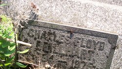
Charles Floyd Brillhart
| Birth | : | 20 Apr 1894 Mapleton, Bourbon County, Kansas, USA |
| Death | : | 21 Jul 1975 Bourbon County, Kansas, USA |
| Burial | : | Calvary Catholic Cemetery, Decatur, Macon County, USA |
| Coordinate | : | 39.8452072, -88.9765015 |
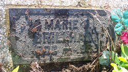
| Description | : | Info from: Deanna Peterson #46859770 Obituary Fort Scott (Kansas) Tribune, July 21,1975 CHARLES F. BRILLHART Charles Floyd Brillhart, 81, retired farmer of Route 1, Mapleton, died Monday 21 July at the Arkhaven Nursing Home. He was born 20 April 1894, at Mapleton, the son of Sperry Albert and Nanny Parker Brillhart. He married Marie Dutiot on 10 July 1918, at Mound City. She died 4 Nov 1968. Mr. Brillhart was a veteran of World War I and a member of the Xenia Baptist Church. He is survived by two sons Raymond D. Brillhart of 201 Caldwell and Rev.... Read More |
frequently asked questions (FAQ):
-
Where is Charles Floyd Brillhart's memorial?
Charles Floyd Brillhart's memorial is located at: Calvary Catholic Cemetery, Decatur, Macon County, USA.
-
When did Charles Floyd Brillhart death?
Charles Floyd Brillhart death on 21 Jul 1975 in Bourbon County, Kansas, USA
-
Where are the coordinates of the Charles Floyd Brillhart's memorial?
Latitude: 39.8452072
Longitude: -88.9765015
Family Members:

Spouse
Siblings
Children
Flowers:


Nearby Cemetories:
1. Calvary Catholic Cemetery
Decatur, Macon County, USA
Coordinate: 39.8452072, -88.9765015
2. Fairlawn Cemetery
Decatur, Macon County, USA
Coordinate: 39.8488998, -88.9863968
3. Saint Johns Episcopal Church Columbarium
Decatur, Macon County, USA
Coordinate: 39.8461020, -88.9570160
4. Graceland Cemetery
Decatur, Macon County, USA
Coordinate: 39.8616982, -88.9764023
5. Greenwood Cemetery
Decatur, Macon County, USA
Coordinate: 39.8319016, -88.9582977
6. Sharon Cemetery
Decatur, Macon County, USA
Coordinate: 39.8431015, -89.0222015
7. Boiling Springs Cemetery
Decatur, Macon County, USA
Coordinate: 39.8838997, -88.9978027
8. Walnut Grove Cemetery
Decatur, Macon County, USA
Coordinate: 39.8033330, -88.9813890
9. Hays Cemetery
Decatur, Macon County, USA
Coordinate: 39.8888890, -88.9422220
10. Salem Cemetery
Decatur, Macon County, USA
Coordinate: 39.7977791, -89.0180588
11. Macon County Memorial Park
Harristown, Macon County, USA
Coordinate: 39.8442001, -89.0532990
12. Mount Gilead Cemetery
Decatur, Macon County, USA
Coordinate: 39.7891655, -88.9508362
13. Spangler Cemetery
Decatur, Macon County, USA
Coordinate: 39.8511009, -88.8989029
14. Peach Orchard Cemetery (Defunct)
Decatur, Macon County, USA
Coordinate: 39.8942020, -88.9254740
15. Saint Johns Lutheran Cemetery
Decatur, Macon County, USA
Coordinate: 39.8637886, -88.8975677
16. Turpin Cemetery
Turpin, Macon County, USA
Coordinate: 39.7941680, -88.9272250
17. South Wheatland Township Cemetery
Decatur, Macon County, USA
Coordinate: 39.7784800, -88.9551560
18. Crum Cemetery
Harristown, Macon County, USA
Coordinate: 39.8266983, -89.0667038
19. North Fork Cemetery
Long Creek, Macon County, USA
Coordinate: 39.8463898, -88.8752747
20. Hudelson Cemetery
Boody, Macon County, USA
Coordinate: 39.7961006, -89.0642014
21. Harristown Cemetery
Harristown, Macon County, USA
Coordinate: 39.8454018, -89.0851974
22. Lester R Barnett Memorial Cemetery
Decatur, Macon County, USA
Coordinate: 39.8511100, -88.8661000
23. Brown Cemetery
Blue Mound, Macon County, USA
Coordinate: 39.7949690, -89.0802380
24. Garver Cemetery
Oreana, Macon County, USA
Coordinate: 39.9008331, -88.8747253