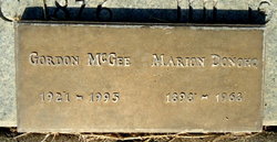
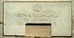
Charles Gordon McGee
| Birth | : | 4 Jan 1921 Bronson, Bourbon County, Kansas, USA |
| Death | : | 4 Apr 1995 Red Bluff, Tehama County, California, USA |
| Burial | : | Eden Valley Cemetery, Seward, Stafford County, USA |
| Coordinate | : | 38.2182999, -98.7853012 |
| Plot | : | Sec 19-20 SA, Space 433C |
| Description | : | father: Charles Ellis McGee Birth 26 Mar 1898 in Blue Mound, Kansas Death 11 Nov 1969 in Hidalgo co., Tx mother: Marion Fern Goodno McGee Birth 01 Dec 1898 in Bronson Kansas Death 15 Apr 1968 in Red Bluff, California |
frequently asked questions (FAQ):
-
Where is Charles Gordon McGee's memorial?
Charles Gordon McGee's memorial is located at: Eden Valley Cemetery, Seward, Stafford County, USA.
-
When did Charles Gordon McGee death?
Charles Gordon McGee death on 4 Apr 1995 in Red Bluff, Tehama County, California, USA
-
Where are the coordinates of the Charles Gordon McGee's memorial?
Latitude: 38.2182999
Longitude: -98.7853012
Family Members:
Parent
Flowers:
Nearby Cemetories:
1. Eden Valley Cemetery
Seward, Stafford County, USA
Coordinate: 38.2182999, -98.7853012
2. Saint Francis Xavier Cemetery
Seward, Stafford County, USA
Coordinate: 38.2038994, -98.8193970
3. Pleasant Ridge Cemetery
Radium, Stafford County, USA
Coordinate: 38.2475014, -98.8758011
4. Peace United Church of Christ Cemetery
Hudson, Stafford County, USA
Coordinate: 38.1591988, -98.6579971
5. Dundee Valley Cemetery
Great Bend, Barton County, USA
Coordinate: 38.3125130, -98.8778980
6. Salem Cemetery
Hudson, Stafford County, USA
Coordinate: 38.1514015, -98.6399994
7. Point View Cemetery
Pawnee County, USA
Coordinate: 38.1306000, -98.9131012
8. Fertig Cemetery
Pawnee County, USA
Coordinate: 38.1458015, -98.9492035
9. Dominican Sisters Resurrection Cemetery
Barton County, USA
Coordinate: 38.3665090, -98.7886990
10. Great Bend Cemetery
Great Bend, Barton County, USA
Coordinate: 38.3680992, -98.7996979
11. Trinity Cemetery
Hudson, Stafford County, USA
Coordinate: 38.1048600, -98.6560400
12. Great Bend Cemetery North
Barton County, USA
Coordinate: 38.3761800, -98.8019840
13. Pawnee Rock State Historic Site
Pawnee Rock, Barton County, USA
Coordinate: 38.2721800, -98.9815300
14. Pawnee Rock Cemetery
Pawnee Rock, Barton County, USA
Coordinate: 38.2771988, -98.9858017
15. Bergthal Mennonite Cemetery
Pawnee Rock, Barton County, USA
Coordinate: 38.3053017, -98.9772034
16. Everett Cemetery
Barton County, USA
Coordinate: 38.3767014, -98.9092026
17. Devore Family Cemetery
St. John, Stafford County, USA
Coordinate: 38.0141200, -98.7947700
18. Lakin Comanche Cemetery
Ellinwood, Barton County, USA
Coordinate: 38.3486000, -98.5736000
19. Feldhut Cemetery
Hudson, Stafford County, USA
Coordinate: 38.0415000, -98.6372600
20. Fairview Park Cemetery
St. John, Stafford County, USA
Coordinate: 38.0078380, -98.7456540
21. Golden Belt Memorial Park
Great Bend, Barton County, USA
Coordinate: 38.4336014, -98.7850037
22. Clarence Township Cemetery
Heizer, Barton County, USA
Coordinate: 38.4052590, -98.9230600
23. Hillcrest Memorial Park
Great Bend, Barton County, USA
Coordinate: 38.4361000, -98.7782974
24. Strobel Cemetery
Stafford, Stafford County, USA
Coordinate: 38.0414009, -98.6007996


