
| Birth | : | unknown New Brunswick, Canada |
| Death | : | 1842 Presque Isle, Aroostook County, Maine, USA |
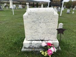
| Burial | : | Riverside Cemetery, Fort Fairfield, Aroostook County, USA |
| Coordinate | : | 46.7750015, -67.8060989 |
| Description | : | Passage from "Aroostook The First Sixty Years" by Clarence Day dated February 1952 states that the first settlers to Letter G and Letter H at the mouth of the St. John River along what would become the international border between Maine and Canada in 1820 were Charles and his brother Lewis Johnston. Letter G and Letter H later became Maysville Maine finally being annexed by Presque Isle in 1883. Youngest son John Johnston, age 15, went to lived with aunt and uncle William and Sarah Johnston in Fort Fairfield after the death of Charles. |
frequently asked questions (FAQ):
-
Where is Charles Johnston's memorial?
Charles Johnston's memorial is located at: Riverside Cemetery, Fort Fairfield, Aroostook County, USA.
-
When did Charles Johnston death?
Charles Johnston death on 1842 in Presque Isle, Aroostook County, Maine, USA
-
Where are the coordinates of the Charles Johnston's memorial?
Latitude: 46.7750015
Longitude: -67.8060989
Family Members:
Parent

Spouse
Siblings
Children
Flowers:


Nearby Cemetories:
1. Riverside Cemetery
Fort Fairfield, Aroostook County, USA
Coordinate: 46.7750015, -67.8060989
2. Saint Denis Catholic Cemetery
Fort Fairfield, Aroostook County, USA
Coordinate: 46.7773440, -67.8355030
3. Harvey Hill Cemetery
McShea, Aroostook County, USA
Coordinate: 46.7567099, -67.8652997
4. Union Cemetery
Fort Fairfield, Aroostook County, USA
Coordinate: 46.7566150, -67.8655240
5. Our Lady of Mercy Cemetery
Aroostook, Victoria County, Canada
Coordinate: 46.7977210, -67.7263700
6. Haines Maple Grove Cemetery
Fort Fairfield, Aroostook County, USA
Coordinate: 46.7233160, -67.8699040
7. Saint Ann Parish - Tobique First Nation Cemetery
Tobique, Victoria County, Canada
Coordinate: 46.7692510, -67.7055300
8. St. John The Evangelist Anglican Cemetery
Four Falls, Victoria County, Canada
Coordinate: 46.8278880, -67.7366425
9. Saint Mary of the Angels
Perth-Andover, Victoria County, Canada
Coordinate: 46.7607665, -67.7018074
10. Presbyterian Rural Cemetery
Perth-Andover, Victoria County, Canada
Coordinate: 46.7600894, -67.7013150
11. Wark Cemetery
Perth-Andover, Victoria County, Canada
Coordinate: 46.7286569, -67.7205736
12. Trinity Anglican Church Cemetery
Perth-Andover, Victoria County, Canada
Coordinate: 46.7571174, -67.6990229
13. Hillcrest Cemetery
Perth-Andover, Victoria County, Canada
Coordinate: 46.7431800, -67.7044100
14. Old Methodist Church Cemetery
Perth-Andover, Victoria County, Canada
Coordinate: 46.7506500, -67.6967900
15. Perth-Andover Baptist Church Cemetery
Perth-Andover, Victoria County, Canada
Coordinate: 46.7478522, -67.6969303
16. Larlee Creek Cemetery
Perth-Andover, Victoria County, Canada
Coordinate: 46.7147700, -67.7183500
17. Greenridge Cemetery
Caribou, Aroostook County, USA
Coordinate: 46.7923622, -67.9321976
18. Old Langley Cemetery
California Settlement, Victoria County, Canada
Coordinate: 46.8671210, -67.7631380
19. Knight Cemetery
Fort Fairfield, Aroostook County, USA
Coordinate: 46.6876150, -67.8778140
20. Kenneson Cemetery
Limestone, Aroostook County, USA
Coordinate: 46.8797900, -67.8047921
21. Bean Family Cemetery
Aroostook County, USA
Coordinate: 46.7396440, -67.9542600
22. Pine Tree Cemetery
Easton, Aroostook County, USA
Coordinate: 46.6774640, -67.8727940
23. Currie Cemetery
North Tilley, Victoria County, Canada
Coordinate: 46.8491850, -67.6886480
24. Beaconsfield Baptist Church Cemetery
Beaconsfield, Victoria County, Canada
Coordinate: 46.6640360, -67.7803850