
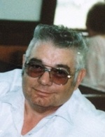

Charles L. Force
| Birth | : | 4 Dec 1943 Nodaway County, Missouri, USA |
| Death | : | 16 Apr 2016 Winchester, Jefferson County, Kansas, USA |
| Burial | : | Luteston Cemetery, Nodaway County, USA |
| Coordinate | : | 40.5393100, -94.6500600 |
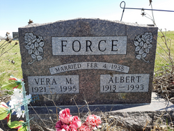
| Description | : | Charles L. Force, age 72, formerly of Sheridan, Missouri, died April 6, 2016. Charles was born December 4, 1943 on a homestead in Nodaway County, Missouri; the son of the late Albert and Vera (Downing) Force. Charles was a graduate of the Sheridan High School. He was a truck driver having hauled gasoline and propane in the area. Charles later trucked over the road for Swift and Company. Charles had been an active part of the Sheridan Community where he had served as a bus driver, on the Sheridan Community Betterment Board, Past President of the Saddle Club, former City Marshall and... Read More |
frequently asked questions (FAQ):
-
Where is Charles L. Force's memorial?
Charles L. Force's memorial is located at: Luteston Cemetery, Nodaway County, USA.
-
When did Charles L. Force death?
Charles L. Force death on 16 Apr 2016 in Winchester, Jefferson County, Kansas, USA
-
Where are the coordinates of the Charles L. Force's memorial?
Latitude: 40.5393100
Longitude: -94.6500600
Family Members:
Parent

Siblings
Flowers:


Nearby Cemetories:
1. Brethren Cemetery
Nodaway County, USA
Coordinate: 40.5046997, -94.6496964
2. New Hope Cemetery
Gaynor, Nodaway County, USA
Coordinate: 40.5457993, -94.7097015
3. McLaughlin Cemetery
Nodaway County, USA
Coordinate: 40.4850006, -94.6464005
4. Kemery Cemetery
Taylor County, USA
Coordinate: 40.6035995, -94.6727982
5. Long Branch Cemetery
Gaynor, Nodaway County, USA
Coordinate: 40.4872017, -94.7177963
6. Daugherty Cemetery
Gaynor, Nodaway County, USA
Coordinate: 40.4927600, -94.7266800
7. Washburn Cemetery
Hopkins, Nodaway County, USA
Coordinate: 40.5127983, -94.7568970
8. Forest Grove Cemetery
Bedford, Taylor County, USA
Coordinate: 40.6253014, -94.6624985
9. Athelstan Cemetery
Athelstan, Taylor County, USA
Coordinate: 40.5727000, -94.5263000
10. Ross Township Cemetery
Bedford, Taylor County, USA
Coordinate: 40.6194000, -94.7303009
11. Saint Joseph Cemetery
Parnell, Nodaway County, USA
Coordinate: 40.4273109, -94.6207733
12. Parnell Cemetery
Parnell, Nodaway County, USA
Coordinate: 40.4273109, -94.6207581
13. Rose Hill Cemetery
Parnell, Nodaway County, USA
Coordinate: 40.4273109, -94.6207581
14. Platteville Cemetery
Platteville, Taylor County, USA
Coordinate: 40.6321983, -94.5571976
15. West Union Cemetery
Orrsburg, Nodaway County, USA
Coordinate: 40.4307400, -94.7186000
16. Hopkins Cemetery
Hopkins, Nodaway County, USA
Coordinate: 40.5689011, -94.8110962
17. Helm Cemetery
Taylor County, USA
Coordinate: 40.6185989, -94.7878036
18. Mohler Cemetery
Bedford, Taylor County, USA
Coordinate: 40.6635000, -94.7073500
19. Willard Cemetery
Taylor County, USA
Coordinate: 40.6007996, -94.8047028
20. Fairview Cemetery
Bedford, Taylor County, USA
Coordinate: 40.6596985, -94.7292023
21. Bedford Cemetery
Bedford, Taylor County, USA
Coordinate: 40.6603012, -94.7343979
22. Tent Chapel Cemetery
Redding, Ringgold County, USA
Coordinate: 40.5750000, -94.4707000
23. White Oak Cemetery
Pickering, Nodaway County, USA
Coordinate: 40.4631004, -94.8097000
24. Wilcox Cemetery
Ravenwood, Nodaway County, USA
Coordinate: 40.3911018, -94.6836014