
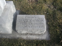

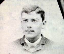
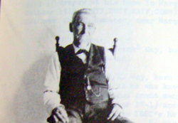
Charles Rudolph May
| Birth | : | 13 Feb 1869 Appanoose County, Iowa, USA |
| Death | : | 13 Jan 1933 Keith County, Nebraska, USA |
| Burial | : | Hebron Cemetery and Mausoleums, Brooks, Bullitt County, USA |
| Coordinate | : | 38.0498150, -85.6781040 |
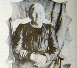
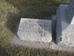
| Description | : | Buried Jan 16,1933 Lot 612 Section B Space- 01 Charles Rudolph May Feb 13,1869-Jan 13,1933 Married Clara Herbig on March 4, 1896, in Hamilton County, Nebraska. He was a carpenter and farmer in Hamilton County. Charles served on the board of trustees for the United Brethren Church in Marquette and helped build the church building in 1917. In 1926, they moved to Long Beach, Calif., where they lived for about one and a half years, then returned to live in Nebraska at Ogallala in Keith County where they resided until his death. |
frequently asked questions (FAQ):
-
Where is Charles Rudolph May's memorial?
Charles Rudolph May's memorial is located at: Hebron Cemetery and Mausoleums, Brooks, Bullitt County, USA.
-
When did Charles Rudolph May death?
Charles Rudolph May death on 13 Jan 1933 in Keith County, Nebraska, USA
-
Where are the coordinates of the Charles Rudolph May's memorial?
Latitude: 38.0498150
Longitude: -85.6781040
Family Members:
Parent
Spouse
Siblings
Children
Flowers:


Nearby Cemetories:
1. Hebron Cemetery and Mausoleums
Brooks, Bullitt County, USA
Coordinate: 38.0498150, -85.6781040
2. Brookland Cemetery
Brooks, Bullitt County, USA
Coordinate: 38.0519840, -85.6832120
3. Rogers Family Graveyard
Fox Chase, Bullitt County, USA
Coordinate: 38.0490400, -85.6888990
4. Rogers Cemetery
Fox Chase, Bullitt County, USA
Coordinate: 38.0440840, -85.6892530
5. Weathers Cemetery
Pioneer Village, Bullitt County, USA
Coordinate: 38.0480995, -85.6611023
6. Brooks Cemetery
Brooks, Bullitt County, USA
Coordinate: 38.0628014, -85.6967010
7. Rogers Family Cemetery
Zoneton, Bullitt County, USA
Coordinate: 38.0739770, -85.6641980
8. Smith Cemetery
Zoneton, Bullitt County, USA
Coordinate: 38.0645800, -85.6499900
9. Collins Cemetery
Shepherdsville, Bullitt County, USA
Coordinate: 38.0269012, -85.6594009
10. Grant Cemetery #2
Shepherdsville, Bullitt County, USA
Coordinate: 38.0507260, -85.6434920
11. Chappell Graveyard
Brooks, Bullitt County, USA
Coordinate: 38.0631600, -85.7146080
12. Grandell Cemetery
Bullitt County, USA
Coordinate: 38.0508003, -85.6352997
13. Calvary Hill Cemetery
Shepherdsville, Bullitt County, USA
Coordinate: 38.0228240, -85.7046370
14. Smith-Hubbs Cemetery
Shepherdsville, Bullitt County, USA
Coordinate: 38.0598850, -85.6311150
15. Tucker Cemetery
Shepherdsville, Bullitt County, USA
Coordinate: 38.0089400, -85.6773390
16. Lone Hill United Baptist Church Cemetery
Louisville, Jefferson County, USA
Coordinate: 38.0904070, -85.6634910
17. Jackson Cemetery
Bullitt County, USA
Coordinate: 38.0080986, -85.6697006
18. Ball Cemetery
Bullitt County, USA
Coordinate: 38.0200005, -85.7217026
19. Gentey Cemetery
Shepherdsville, Bullitt County, USA
Coordinate: 38.0555992, -85.6185989
20. Stallings-Simmons Cemetery
Bullitt County, USA
Coordinate: 38.0105650, -85.6444570
21. Pleasant Grove Cemetery
Shepherdsville, Bullitt County, USA
Coordinate: 38.0202020, -85.6305600
22. Stallings Cemetery
Bullitt County, USA
Coordinate: 38.0153008, -85.6355972
23. Quick Cemetery
Brooks, Bullitt County, USA
Coordinate: 38.0505981, -85.7397003
24. Cooper Cemetery
Jefferson County, USA
Coordinate: 38.0964012, -85.6594009