
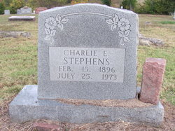
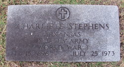

Charlie Elsie Stephens
| Birth | : | 15 Feb 1896 Alton, Oregon County, Missouri, USA |
| Death | : | 25 Jul 1973 Poplar Bluff, Butler County, Missouri, USA |
| Burial | : | Peace Creek Cemetery, Stafford, Stafford County, USA |
| Coordinate | : | 38.0635986, -98.4725037 |
| Description | : | Charlie Elsie Stephens, son of the late Ben and Molley Rice Stephens, was born February 15, 1896 in Alton, MO and departed this life July 25, 1973 in the VA Hospital in Poplar Bluff, MO at the age of 77 years, five months, and ten days. He was united in marriage to Thelma Ashcraft, and to this union three children were born. She preceded him in death. Later he was united in marriage to Mabel Case, August 15, 1965 at Pocahontas, AR. He is survived by his wife, Mabel Stephens, of their home at Myrtle, MO; two sons, Scott Stephens of Pontiac,... Read More |
frequently asked questions (FAQ):
-
Where is Charlie Elsie Stephens's memorial?
Charlie Elsie Stephens's memorial is located at: Peace Creek Cemetery, Stafford, Stafford County, USA.
-
When did Charlie Elsie Stephens death?
Charlie Elsie Stephens death on 25 Jul 1973 in Poplar Bluff, Butler County, Missouri, USA
-
Where are the coordinates of the Charlie Elsie Stephens's memorial?
Latitude: 38.0635986
Longitude: -98.4725037
Family Members:

Flowers:


Nearby Cemetories:
1. Peace Creek Cemetery
Stafford, Stafford County, USA
Coordinate: 38.0635986, -98.4725037
2. Hayes Township Cemetery
Sylvia, Reno County, USA
Coordinate: 38.0451500, -98.4088600
3. Strobel Cemetery
Stafford, Stafford County, USA
Coordinate: 38.0414009, -98.6007996
4. Lutheran Cemetery
Huntsville, Reno County, USA
Coordinate: 38.0428009, -98.3341980
5. Sylvia Cemetery
Sylvia, Reno County, USA
Coordinate: 37.9561005, -98.3889008
6. Hazen Cemetery
Sylvia, Reno County, USA
Coordinate: 37.9653015, -98.3617020
7. Feldhut Cemetery
Hudson, Stafford County, USA
Coordinate: 38.0415000, -98.6372600
8. Pleasant View Cemetery
Huntsville, Reno County, USA
Coordinate: 38.0720711, -98.2889099
9. Verning Cemetery
Stafford, Stafford County, USA
Coordinate: 37.9986000, -98.6438980
10. Trinity Cemetery
Hudson, Stafford County, USA
Coordinate: 38.1048600, -98.6560400
11. Pleasant Valley Cemetery
Stafford, Stafford County, USA
Coordinate: 37.9253006, -98.5535965
12. Plevna Cemetery
Plevna, Reno County, USA
Coordinate: 37.9693985, -98.3167038
13. Stafford Cemetery
Stafford, Stafford County, USA
Coordinate: 37.9536018, -98.6138992
14. Salem Cemetery
Hudson, Stafford County, USA
Coordinate: 38.1514015, -98.6399994
15. Glendale Cemetery
Reno County, USA
Coordinate: 37.9043999, -98.3981018
16. Peace Valley Cemetery
Reno County, USA
Coordinate: 38.1521988, -98.2882996
17. Peace United Church of Christ Cemetery
Hudson, Stafford County, USA
Coordinate: 38.1591988, -98.6579971
18. Sterling Mennonite Cemetery
Nickerson, Reno County, USA
Coordinate: 38.0866590, -98.2527760
19. Bethel Peace Cemetery
Reno County, USA
Coordinate: 38.0581017, -98.2332993
20. Prairie Chapel Cemetery
Stafford County, USA
Coordinate: 37.8978004, -98.6493988
21. Fairview Park Cemetery
St. John, Stafford County, USA
Coordinate: 38.0078380, -98.7456540
22. Alden Valley Cemetery
Alden, Rice County, USA
Coordinate: 38.2461400, -98.3065900
23. Old Neola Cemetery
Zenith, Stafford County, USA
Coordinate: 37.8377991, -98.4903030
24. Hilltop Cemetery
Raymond, Rice County, USA
Coordinate: 38.2886009, -98.4231033