Chester Alfred “Bud” Stanford
| Birth | : | 14 Apr 1916 |
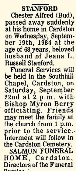
| Death | : | 19 Sep 1984 |
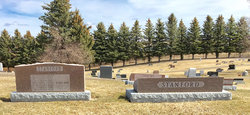
| Burial | : | Cardston Cemetery, Cardston, Claresholm Census Division, Canada |
| Coordinate | : | 49.1906900, -113.3415300 |
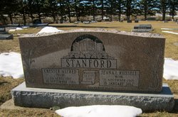
| Inscription | : | [Cardston Temple] STANFORD CHESTER ALFRED (BUD) 14 April 1916 19 September 1984 Married Sept. 29 1943 JEANA L. RUSSELL Mom 21 November 1913 19 January 2012 God Be With |
frequently asked questions (FAQ):
-
Where is Chester Alfred “Bud” Stanford's memorial?
Chester Alfred “Bud” Stanford's memorial is located at: Cardston Cemetery, Cardston, Claresholm Census Division, Canada.
-
When did Chester Alfred “Bud” Stanford death?
Chester Alfred “Bud” Stanford death on 19 Sep 1984 in
-
Where are the coordinates of the Chester Alfred “Bud” Stanford's memorial?
Latitude: 49.1906900
Longitude: -113.3415300
Family Members:
Parent
Spouse
Siblings
Children
Nearby Cemetories:
1. Cardston Cemetery
Cardston, Claresholm Census Division, Canada
Coordinate: 49.1906900, -113.3415300
2. East Cardston Hutterite Cemetery
Cardston, Claresholm Census Division, Canada
Coordinate: 49.1908348, -113.2258004
3. Aetna Cemetery
Aetna, Claresholm Census Division, Canada
Coordinate: 49.1163000, -113.2707000
4. Leavitt Cemetery
Leavitt, Claresholm Census Division, Canada
Coordinate: 49.1830500, -113.4768200
5. Saint Stephen's Cemetery
Beazer, Claresholm Census Division, Canada
Coordinate: 49.0937300, -113.3852700
6. Woolford Cemetery
Woolford, Claresholm Census Division, Canada
Coordinate: 49.1945800, -113.1652300
7. West Raley Hutterite Cemetery
Raley, Claresholm Census Division, Canada
Coordinate: 49.2908857, -113.2283616
8. Kimball Cemetery
Kimball, Claresholm Census Division, Canada
Coordinate: 49.0949000, -113.2077000
9. Beazer Cemetery
Beazer, Claresholm Census Division, Canada
Coordinate: 49.1097500, -113.4975800
10. Big Bend Hutterite Colony
Cardston, Claresholm Census Division, Canada
Coordinate: 49.1636110, -113.1411110
11. Pioneer Cemetery
Levern, Claresholm Census Division, Canada
Coordinate: 49.3489700, -113.4642000
12. Mountain View Cemetery
Mountain View, Claresholm Census Division, Canada
Coordinate: 49.1293300, -113.5986300
13. Taylorville Cemetery
Taylorville, Claresholm Census Division, Canada
Coordinate: 49.0498100, -113.1404000
14. Blue Ridge Hutterite Cemetery
Hill Spring, Claresholm Census Division, Canada
Coordinate: 49.2320117, -113.6305672
15. Hill Spring Pioneer Cemetery
Hill Spring, Claresholm Census Division, Canada
Coordinate: 49.3035000, -113.6249000
16. Glenwood Cemetery
Glenwood, Claresholm Census Division, Canada
Coordinate: 49.3859800, -113.5003500
17. Hill Spring Cemetery
Hill Spring, Claresholm Census Division, Canada
Coordinate: 49.3128700, -113.6436100
18. Spring Coulee Cemetery
Spring Coulee, Claresholm Census Division, Canada
Coordinate: 49.3412100, -113.0541400
19. Waterton Hutterite Cemetery
Hill Spring, Claresholm Census Division, Canada
Coordinate: 49.2661602, -113.6918691
20. Spring Valley Hutterite Colony Cemetery
Spring Coulee, Claresholm Census Division, Canada
Coordinate: 49.3517043, -113.0551519
21. Riverside Hutterite Colony Cemetery
Glenwood, Claresholm Census Division, Canada
Coordinate: 49.4379404, -113.4492438
22. Saint Catherine Cemetery
Stand Off, Claresholm Census Division, Canada
Coordinate: 49.4516900, -113.3112300
23. Hartley Cemetery
Hartleyville, Claresholm Census Division, Canada
Coordinate: 49.3777000, -113.6227000
24. Thompson Hutterite Cemetery
Glenwood, Claresholm Census Division, Canada
Coordinate: 49.4269974, -113.5401975


