
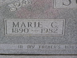
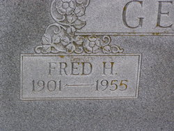
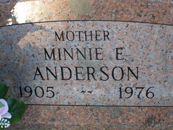
| Birth | : | 29 Oct 1899 Garland, Seward County, Nebraska, USA |
| Death | : | 8 Oct 1975 Lincoln, Lancaster County, Nebraska, USA |
| Burial | : | Boston Cemetery and Crematorium, Boston, Boston Borough, England |
| Coordinate | : | 52.9888100, -0.0273450 |
| Plot | : | Sec. 05 |
frequently asked questions (FAQ):
-
Where is Clara E. Gehle Breck's memorial?
Clara E. Gehle Breck's memorial is located at: Boston Cemetery and Crematorium, Boston, Boston Borough, England.
-
When did Clara E. Gehle Breck death?
Clara E. Gehle Breck death on 8 Oct 1975 in Lincoln, Lancaster County, Nebraska, USA
-
Where are the coordinates of the Clara E. Gehle Breck's memorial?
Latitude: 52.9888100
Longitude: -0.0273450
Family Members:
Parent

Spouse
Siblings
Flowers:


Nearby Cemetories:
1. Boston Cemetery and Crematorium
Boston, Boston Borough, England
Coordinate: 52.9888100, -0.0273450
2. Boston Centenary Methodist Churchyard
Boston Borough, England
Coordinate: 52.9803214, -0.0241620
3. Holy Trinity Churchyard
Boston, Boston Borough, England
Coordinate: 52.9837160, -0.0150690
4. Black Friars Priory
Boston, Boston Borough, England
Coordinate: 52.9786110, -0.0258330
5. St. Botolph Churchyard
Boston, Boston Borough, England
Coordinate: 52.9785700, -0.0252740
6. Unitarian Burial Ground
Boston, Boston Borough, England
Coordinate: 52.9765987, -0.0212365
7. St. Aiden's Churchyard
Boston Borough, England
Coordinate: 52.9727909, -0.0250366
8. Boston Baptist Cemetery
Boston, Boston Borough, England
Coordinate: 52.9726351, -0.0477945
9. St. Thomas Churchyard
Skirbeck, Boston Borough, England
Coordinate: 52.9649810, -0.0296080
10. Tranquility Gardens
Quesnel, Cariboo Regional District, Canada
Coordinate: 53.0184530, 0.0000000
11. St. Leodegar Churchyard
Wyberton, Boston Borough, England
Coordinate: 52.9480560, -0.0236110
12. Wyberton Cemetery
Wyberton, Boston Borough, England
Coordinate: 52.9480560, -0.0225000
13. St. James Churchyard
Freiston, Boston Borough, England
Coordinate: 52.9738620, 0.0484651
14. St. Peter's Churchyard
Frithville, East Lindsey District, England
Coordinate: 53.0380330, -0.0391600
15. St. Gilbert of Sempringham
Brothertoft, Boston Borough, England
Coordinate: 52.9987500, -0.1090160
16. St Mary's Churchyard
Frampton, Boston Borough, England
Coordinate: 52.9335410, -0.0289950
17. St. Andrew's Churchyard
Butterwick, Boston Borough, England
Coordinate: 52.9837000, 0.0655000
18. Kirton in Holland New Cemetery
Kirton, Boston Borough, England
Coordinate: 52.9361110, -0.0597220
19. Kirton in Holland Old Cemetery
Kirton, Boston Borough, England
Coordinate: 52.9352780, -0.0583330
20. Church of St. Peter and St. Paul
Kirton, Boston Borough, England
Coordinate: 52.9280560, -0.0597220
21. St. Margaret Churchyard
Langrick, East Lindsey District, England
Coordinate: 53.0206370, -0.1214770
22. All Saints Churchyard
Benington, Boston Borough, England
Coordinate: 52.9977010, 0.0803000
23. St. Mary's Churchyard
Old Leake, Boston Borough, England
Coordinate: 53.0311810, 0.0967100
24. St. Paul's Churchyard
Carrington, East Lindsey District, England
Coordinate: 53.0783300, -0.0437200