
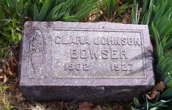
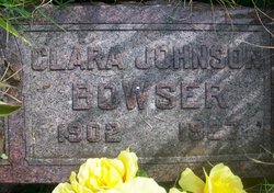
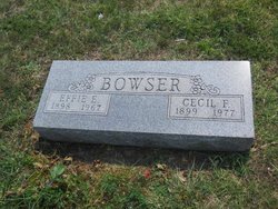
Clara Ellen Johnson Bowser
| Birth | : | 31 Aug 1902 Soldier, Jackson County, Kansas, USA |
| Death | : | 27 Jun 1927 Holton, Jackson County, Kansas, USA |
| Burial | : | Prospect Cemetery, Hollow Rock, Carroll County, USA |
| Coordinate | : | 36.0346985, -88.2703018 |
| Plot | : | Section C |
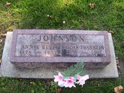
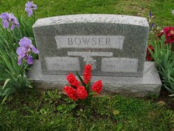
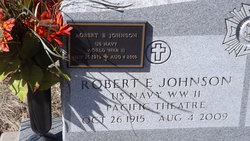
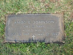
| Description | : | The following biographical information was provided by FindAGrave contributor, Jen: Clara Ellen Johnson, third child, second daughter of Annie Bell Anderson and Edgar Franklin "Frank" Johnson was born August 31, 1902 at Soldier, Kansas. She attended the Circleville High School for 2 yrs. and graduated from the Mayetta High School with the class of 1922. Clara and Ora were married in Holton, Ks. Oct 3, 1922. They lived on a farm on the reservation six miles southwest of Holton, Ks. They had two babies both died in infancy. Clara died almost instantly, when the car in which she was riding overturned... Read More |
frequently asked questions (FAQ):
-
Where is Clara Ellen Johnson Bowser's memorial?
Clara Ellen Johnson Bowser's memorial is located at: Prospect Cemetery, Hollow Rock, Carroll County, USA.
-
When did Clara Ellen Johnson Bowser death?
Clara Ellen Johnson Bowser death on 27 Jun 1927 in Holton, Jackson County, Kansas, USA
-
Where are the coordinates of the Clara Ellen Johnson Bowser's memorial?
Latitude: 36.0346985
Longitude: -88.2703018
Family Members:
Parent

Spouse
Siblings
Children

Flowers:


Nearby Cemetories:
1. Prospect Cemetery
Hollow Rock, Carroll County, USA
Coordinate: 36.0346985, -88.2703018
2. Rowland Cemetery #2
Bruceton, Carroll County, USA
Coordinate: 36.0349500, -88.2608700
3. Nebo - Pisgah Cemetery
Hollow Rock, Carroll County, USA
Coordinate: 36.0427190, -88.2604730
4. Hollow Rock Church Cemetery
Bruceton, Carroll County, USA
Coordinate: 36.0393550, -88.2493720
5. Rowland Cemetery
Hollow Rock, Carroll County, USA
Coordinate: 36.0161184, -88.2745960
6. New Prospect Cemetery
Hollow Rock, Carroll County, USA
Coordinate: 36.0579930, -88.2734330
7. Old Pisgah Church Cemetery
Bruceton, Carroll County, USA
Coordinate: 36.0602989, -88.2553024
8. Thompson Cemetery
Bruceton, Carroll County, USA
Coordinate: 36.0321880, -88.3202350
9. Hebron Cemetery
Carroll County, USA
Coordinate: 36.0410995, -88.3199997
10. Park Cemetery
Bruceton, Carroll County, USA
Coordinate: 36.0110390, -88.2281580
11. Pisgah Cemetery
Hollow Rock, Carroll County, USA
Coordinate: 36.0788570, -88.2638470
12. Nesbitt Cemetery
Hollow Rock, Carroll County, USA
Coordinate: 36.0633011, -88.3218994
13. Garrett Cemetery
Buena Vista, Carroll County, USA
Coordinate: 35.9925000, -88.2339000
14. Hamilton Cemetery
Carroll County, USA
Coordinate: 36.0069008, -88.3289032
15. Marlboro Church of Christ Cemetery
Bruceton, Carroll County, USA
Coordinate: 36.0919200, -88.2693600
16. Marlsboro Missionary Baptist Church Cemetery
Carroll County, USA
Coordinate: 36.0928001, -88.2694016
17. Ray Cemetery
Carroll County, USA
Coordinate: 35.9930992, -88.3225021
18. Spellings Cemetery
Buena Vista, Carroll County, USA
Coordinate: 35.9787980, -88.2954990
19. Mount Pleasant Baptist Church Cemetery
Huntingdon, Carroll County, USA
Coordinate: 36.0388090, -88.3440580
20. Mebane Cemetery
Carroll County, USA
Coordinate: 36.0689011, -88.3311005
21. Mount Carmel Cemetery
Camden, Benton County, USA
Coordinate: 36.0598850, -88.2017880
22. McAuley Cemetery
Buena Vista, Carroll County, USA
Coordinate: 35.9822006, -88.3091965
23. Groom Family Cemetery
Vale, Carroll County, USA
Coordinate: 36.0977670, -88.2524950
24. Barren Springs Church Cemetery
Hollow Rock, Carroll County, USA
Coordinate: 36.0890140, -88.3152590