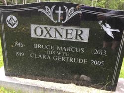
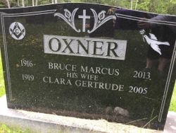
Clara Gertrude Hiltz Oxner
| Birth | : | 29 Sep 1919 Marriotts Cove, Lunenburg County, Nova Scotia, Canada |
| Death | : | 12 Sep 2005 Chester, Lunenburg County, Nova Scotia, Canada |
| Burial | : | St. John's Anglican Cemetery, Chester Basin, Lunenburg County, Canada |
| Coordinate | : | 44.5544722, -64.3139722 |
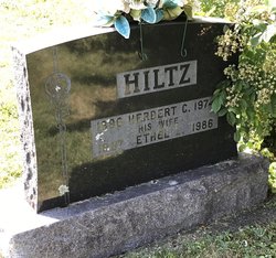
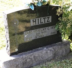
| Description | : | Clara Oxner - 85, Chester Basin, died September 12, 2005, in Shoreham Village Home for Special Care, Chester. Born in Marriott's Cove, Lunenburg Co., she was a daughter of the late Herbert and Ethel (Maddeford) Hiltz. She was a member of St. John's Anglican Church, Chester Basin, where she sang in the choir for over 50 years, and was an honorary member of the church guild and auxiliary. She was superintendent and taught Sunday school for many years, was a Girl Guide leader, associate member of Everett Branch 88, Royal Canadian Legion, Chester Basin, life member of the Legion... Read More |
frequently asked questions (FAQ):
-
Where is Clara Gertrude Hiltz Oxner's memorial?
Clara Gertrude Hiltz Oxner's memorial is located at: St. John's Anglican Cemetery, Chester Basin, Lunenburg County, Canada.
-
When did Clara Gertrude Hiltz Oxner death?
Clara Gertrude Hiltz Oxner death on 12 Sep 2005 in Chester, Lunenburg County, Nova Scotia, Canada
-
Where are the coordinates of the Clara Gertrude Hiltz Oxner's memorial?
Latitude: 44.5544722
Longitude: -64.3139722
Family Members:
Parent
Spouse
Siblings
Flowers:
Nearby Cemetories:
1. St. John's Anglican Cemetery
Chester Basin, Lunenburg County, Canada
Coordinate: 44.5544722, -64.3139722
2. Chester Basin Cemetery
Chester, Lunenburg County, Canada
Coordinate: 44.5644700, -64.3074000
3. Basin View Anglican Cemetery
Chester Basin, Lunenburg County, Canada
Coordinate: 44.5645278, -64.3068333
4. Lakeview Baptist Cemetery
Chester Basin, Lunenburg County, Canada
Coordinate: 44.5637778, -64.3231667
5. Aenon Baptist Church Cemetery
Chester Basin, Lunenburg County, Canada
Coordinate: 44.5673000, -64.3101000
6. Oak Island Memorial
Lunenburg County, Canada
Coordinate: 44.5125110, -64.3002000
7. Old Baptist Burial Ground
Chester, Lunenburg County, Canada
Coordinate: 44.5406200, -64.2478600
8. Bayview Anglican Cemetery
Chester, Lunenburg County, Canada
Coordinate: 44.5514565, -64.2423782
9. Martin's Point Cemetery
Martins Point, Lunenburg County, Canada
Coordinate: 44.5026000, -64.3157700
10. St. Stephen's Anglican Church Cemetery
Chester, Lunenburg County, Canada
Coordinate: 44.5418600, -64.2419200
11. Saint Augustine's Roman Catholic Cemetery
Chester, Lunenburg County, Canada
Coordinate: 44.5410500, -64.2415900
12. Pine Hill Cemetery
Chester, Lunenburg County, Canada
Coordinate: 44.5428300, -64.2274500
13. Saint Martin's Anglican Cemetery
Martins River, Lunenburg County, Canada
Coordinate: 44.4829600, -64.3384700
14. Indian Point Cemetery
Indian Point, Lunenburg County, Canada
Coordinate: 44.4601288, -64.3141403
15. Clearland Hillside Cemetery
Clearland, Lunenburg County, Canada
Coordinate: 44.4646000, -64.3949030
16. Bayview Cemetery
Mahone Bay, Lunenburg County, Canada
Coordinate: 44.4537700, -64.3819700
17. Canaan Baptist Cemetery
Canaan, Lunenburg County, Canada
Coordinate: 44.6635900, -64.2557200
18. Saint George's Cemetery
East River Point, Lunenburg County, Canada
Coordinate: 44.5704800, -64.1473500
19. Park Cemetery
Mahone Bay, Lunenburg County, Canada
Coordinate: 44.4465300, -64.3892400
20. Garden of Rest Cemetery
Blockhouse, Lunenburg County, Canada
Coordinate: 44.4468900, -64.4110800
21. Blockhouse Cemetery
Blockhouse, Lunenburg County, Canada
Coordinate: 44.4479400, -64.4228800
22. Lower Cornwall Graveyard
Lower New Cornwall, Lunenburg County, Canada
Coordinate: 44.4912230, -64.4846840
23. Big Tancook Island Cemetery
Lunenburg County, Canada
Coordinate: 44.4584000, -64.1735200
24. Farmville Cemetery
Farmville, Lunenburg County, Canada
Coordinate: 44.4649900, -64.4690100

