
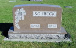
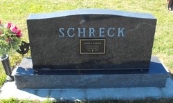
Clara Josephine Heithoff Schreck
| Birth | : | 22 Feb 1892 Antelope County, Nebraska, USA |
| Death | : | 24 Oct 1983 Templeton, Carroll County, Iowa, USA |
| Burial | : | Sacred Heart Cemetery, Templeton, Carroll County, USA |
| Coordinate | : | 41.9138746, -94.9460994 |
| Description | : | Clara Josephine Heithoff, born in Raeville, Cedar Twnshp, Antelope, Nebraska, was the daughter of John Bernard Heithoff and Caroline Schoeppner. She married Louis George Schreck on June 1, 1920 in Sacred Heart Church, Templeton, Carroll Co., IA. |
frequently asked questions (FAQ):
-
Where is Clara Josephine Heithoff Schreck's memorial?
Clara Josephine Heithoff Schreck's memorial is located at: Sacred Heart Cemetery, Templeton, Carroll County, USA.
-
When did Clara Josephine Heithoff Schreck death?
Clara Josephine Heithoff Schreck death on 24 Oct 1983 in Templeton, Carroll County, Iowa, USA
-
Where are the coordinates of the Clara Josephine Heithoff Schreck's memorial?
Latitude: 41.9138746
Longitude: -94.9460994
Family Members:
Parent

Spouse
Siblings

Children

Flowers:


Nearby Cemetories:
1. Sacred Heart Cemetery
Templeton, Carroll County, USA
Coordinate: 41.9138746, -94.9460994
2. Elba Cemetery
Templeton, Carroll County, USA
Coordinate: 41.9068985, -94.9131012
3. Sacred Heart Cemetery
Manning, Carroll County, USA
Coordinate: 41.9132500, -95.0540000
4. Gray Cemetery
Gray, Audubon County, USA
Coordinate: 41.8414001, -94.9946976
5. Manning Cemetery
Manning, Carroll County, USA
Coordinate: 41.8990000, -95.0620000
6. Holy Angels Cemetery
Carroll County, USA
Coordinate: 42.0014000, -94.9141998
7. Cameron Cemetery
Audubon County, USA
Coordinate: 41.8236008, -94.9167023
8. Dedham Cemetery
Dedham, Carroll County, USA
Coordinate: 41.8993988, -94.8225021
9. Saint Josephs Cemetery
Dedham, Carroll County, USA
Coordinate: 41.8993988, -94.8210983
10. Saint Augustine Cemetery
Halbur, Carroll County, USA
Coordinate: 42.0066986, -94.9744034
11. Lincoln Township Cemetery
Gray, Audubon County, USA
Coordinate: 41.8198130, -95.0154970
12. Saint Marys Catholic Cemetery
Willey, Carroll County, USA
Coordinate: 41.9783363, -94.8212204
13. Iowa Township Cemetery
Aspinwall, Crawford County, USA
Coordinate: 41.9216995, -95.1113968
14. McCurdy Cemetery
Carroll County, USA
Coordinate: 41.9403000, -94.7649994
15. Viola Center Cemetery
Viola Center, Audubon County, USA
Coordinate: 41.8236008, -94.8016968
16. Old Carrollton Cemetery
Carrollton, Carroll County, USA
Coordinate: 41.9233017, -94.7403030
17. Mount Olivet Cemetery
Carroll, Carroll County, USA
Coordinate: 42.0536340, -94.8595510
18. Carroll City Cemetery
Carroll, Carroll County, USA
Coordinate: 42.0560963, -94.8599856
19. Hayes Township Cemetery
Westside, Crawford County, USA
Coordinate: 42.0083199, -95.1216583
20. Luccocks Grove Cemetery
Audubon County, USA
Coordinate: 41.7619019, -94.8653030
21. Douglas Township Cemetery
Audubon County, USA
Coordinate: 41.7611008, -95.0282974
22. Oak Hill Cemetery
Coon Rapids, Carroll County, USA
Coordinate: 41.9053001, -94.7200012
23. Westside Cemetery
Westside, Crawford County, USA
Coordinate: 42.0602989, -95.0922012
24. Saint Francis Cemetery
Maple River, Carroll County, USA
Coordinate: 42.0969009, -94.9372025