
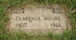
Clarence “Bud” Moore
| Birth | : | 18 Jun 1907 Doe Run, St. Francois County, Missouri, USA |
| Death | : | 9 May 1966 Farmington, St. Francois County, Missouri, USA |
| Burial | : | Riverview Cemetery, Wallaceburg, Chatham-Kent Municipality, Canada |
| Coordinate | : | 42.5972939, -82.3593521 |
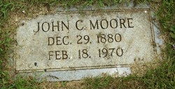
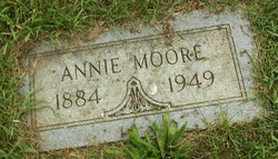
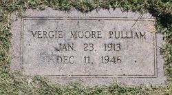
| Description | : | Clarence "Bud" Moore of Elvins died May 9, at Mineral Area Osteopathic Hospital at the age of 58 years. He was born June 18, 1907, in Doe Run, Mo., the son of John C. Moore and the late Annie Weiss Moore. His mother preceded him in death in 1949, also two sisters, Virgie and Rosie. Surviving are his wife Mamie Anderson Moore of Elvins, his father John C. Moore of Flat River; his step-mother Maudie Moore of Flat River; and the following brothers and sisters: Florence (Mrs. John McCoy) of Farmington; Trixie (Mrs. Denver Clubb)... Read More |
frequently asked questions (FAQ):
-
Where is Clarence “Bud” Moore's memorial?
Clarence “Bud” Moore's memorial is located at: Riverview Cemetery, Wallaceburg, Chatham-Kent Municipality, Canada.
-
When did Clarence “Bud” Moore death?
Clarence “Bud” Moore death on 9 May 1966 in Farmington, St. Francois County, Missouri, USA
-
Where are the coordinates of the Clarence “Bud” Moore's memorial?
Latitude: 42.5972939
Longitude: -82.3593521
Family Members:
Parent
Siblings

Flowers:


Nearby Cemetories:
1. Riverview Cemetery
Wallaceburg, Chatham-Kent Municipality, Canada
Coordinate: 42.5972939, -82.3593521
2. Little-Mickle Cemetery
Chatham-Kent Municipality, Canada
Coordinate: 42.5979620, -82.3431810
3. Baldoon Cemetery
Baldoon, Chatham-Kent Municipality, Canada
Coordinate: 42.5783400, -82.4139700
4. Oldfied United Church Cemetery
Oldfield, Chatham-Kent Municipality, Canada
Coordinate: 42.5423110, -82.3156590
5. Oldfield Methodist Cemetery
Oldfield, Chatham-Kent Municipality, Canada
Coordinate: 42.5422400, -82.3156500
6. Crawford Cemetery
Electric, Chatham-Kent Municipality, Canada
Coordinate: 42.5166700, -82.3835800
7. Duthil Cemetery
Duthill, Lambton County, Canada
Coordinate: 42.6936780, -82.3888290
8. Owen Cemetery
Baldoon, Chatham-Kent Municipality, Canada
Coordinate: 42.4925900, -82.3677600
9. Bishop Cemetery
Dover, Chatham-Kent Municipality, Canada
Coordinate: 42.4915690, -82.3656500
10. Highbanks Cemetery
Walpole Island, Lambton County, Canada
Coordinate: 42.6322100, -82.4975100
11. McDonald Cemetery
Port Lambton, Lambton County, Canada
Coordinate: 42.6567030, -82.4978400
12. British American Institute Cemetery
Dresden, Chatham-Kent Municipality, Canada
Coordinate: 42.5858100, -82.1968700
13. Uncle Tom's Cabin Historic Site
Dresden, Chatham-Kent Municipality, Canada
Coordinate: 42.5845947, -82.1965866
14. Sacred Heart Roman Catholic Cemetery
Port Lambton, Lambton County, Canada
Coordinate: 42.6578230, -82.5068090
15. Nazrey Negro Cemetery
Chatham, Chatham-Kent Municipality, Canada
Coordinate: 42.4856140, -82.2728380
16. Wilkesport Cemetery
Sombra, Lambton County, Canada
Coordinate: 42.7281100, -82.3564000
17. Burnham Cemetery
Sombra, Lambton County, Canada
Coordinate: 42.6812100, -82.4963200
18. Oaklawn Cemetery
Algonac, St. Clair County, USA
Coordinate: 42.6241989, -82.5408020
19. Saint Catherine Cemetery
Algonac, St. Clair County, USA
Coordinate: 42.6268997, -82.5417023
20. Dresden Cemetery
Dresden, Chatham-Kent Municipality, Canada
Coordinate: 42.5962300, -82.1716500
21. Desmond-Farslow-Traxler Cemetery
Camden, Chatham-Kent Municipality, Canada
Coordinate: 42.6020230, -82.1516970
22. Blackburn Union Burial Grounds
Dresden, Chatham-Kent Municipality, Canada
Coordinate: 42.6011300, -82.1509100
23. Holy Cross Cemetery
Marine City, St. Clair County, USA
Coordinate: 42.7083015, -82.5083008
24. Black Creek Cemetery
Sombra, Lambton County, Canada
Coordinate: 42.7511100, -82.3110300