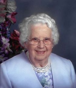
Clarence Paul Gloyer
| Birth | : | 12 Jan 1914 Colon, Saunders County, Nebraska, USA |
| Death | : | 26 Feb 1996 Le Mars, Plymouth County, Iowa, USA |
| Burial | : | Mountain View Cemetery, Trail, Kootenay Boundary Regional District, Canada |
| Coordinate | : | 49.0756500, -117.7818900 |
| Description | : | Clarence Paul Gloyer, 82, of Merrill, died Monday, Feb. 26,1996, at Plymouth Manor Care Center in Le Mars. Mr. Gloyer was born Jan. 12,1914 in Colon, Neb. the son Max and Hattie (Anthony) Gloyer. He moved with his family to a farm, west of Whiting at the age of 7. He, attended country school and graduated from Whiting High School. He married Delores Glau Dec. 20, 1941, in Sioux City. The couple made their home near Whiting until 1962 when they moved to & farm west of Merrill: They retired in 1975 and moved to Merrill... Read More |
frequently asked questions (FAQ):
-
Where is Clarence Paul Gloyer's memorial?
Clarence Paul Gloyer's memorial is located at: Mountain View Cemetery, Trail, Kootenay Boundary Regional District, Canada.
-
When did Clarence Paul Gloyer death?
Clarence Paul Gloyer death on 26 Feb 1996 in Le Mars, Plymouth County, Iowa, USA
-
Where are the coordinates of the Clarence Paul Gloyer's memorial?
Latitude: 49.0756500
Longitude: -117.7818900
Family Members:
Parent
Spouse
Flowers:
Nearby Cemetories:
1. Mountain View Cemetery
Trail, Kootenay Boundary Regional District, Canada
Coordinate: 49.0756500, -117.7818900
2. Old Trail Cemetery
Trail, Kootenay Boundary Regional District, Canada
Coordinate: 49.0773200, -117.7761000
3. Columbia Cemetery
Rossland, Kootenay Boundary Regional District, Canada
Coordinate: 49.0798540, -117.7841230
4. Calvary Catholic Cemetery
Rossland, Kootenay Boundary Regional District, Canada
Coordinate: 49.0715700, -117.7931900
5. Columbia Riverview Cemetery
Trail, Kootenay Boundary Regional District, Canada
Coordinate: 49.0976200, -117.6678700
6. Boundary Cemetery
Northport, Stevens County, USA
Coordinate: 48.9974900, -117.6293200
7. Pend'Oreille Cemetery
Trail, Kootenay Boundary Regional District, Canada
Coordinate: 49.0064500, -117.6037500
8. Fruitvale Memorial Cemetery
Fruitvale, Kootenay Boundary Regional District, Canada
Coordinate: 49.1063200, -117.5487500
9. Riverview Cemetery
Northport, Stevens County, USA
Coordinate: 48.8958015, -117.8031006
10. Forest Home Cemetery
Northport, Stevens County, USA
Coordinate: 48.8955994, -117.7388992
11. Ootischenia Cemetery
Ootischenia, Central Kootenay Regional District, Canada
Coordinate: 49.2785350, -117.6401060
12. Kinnaird Park Memorial Cemetery
Castlegar, Central Kootenay Regional District, Canada
Coordinate: 49.2874908, -117.6594009
13. Zuckerberg Island
Castlegar, Central Kootenay Regional District, Canada
Coordinate: 49.3157650, -117.6558490
14. Brilliant USCC Cemetery
Castlegar, Central Kootenay Regional District, Canada
Coordinate: 49.3200600, -117.6457710
15. Verigin's Memorial Park
Brilliant, Central Kootenay Regional District, Canada
Coordinate: 49.3193800, -117.6314800
16. Robson Community Memorial Cemetery
Robson, Central Kootenay Regional District, Canada
Coordinate: 49.3331610, -117.6920910
17. Cascade Cemetery
Cascade, Kootenay Boundary Regional District, Canada
Coordinate: 49.0188990, -118.2247300
18. Laurier Cemetery
Ferry County, USA
Coordinate: 48.9855500, -118.2189000
19. Pass Creek Doukhobor Cemetery
Pass Creek, Central Kootenay Regional District, Canada
Coordinate: 49.3829200, -117.6802700
20. Thrums Doukhobor Cemetery
Castlegar, Central Kootenay Regional District, Canada
Coordinate: 49.3684700, -117.5671860
21. Harvey Gravesite
Pend Oreille County, USA
Coordinate: 48.9555100, -117.3152300
22. Salmo Cemetery
Salmo, Central Kootenay Regional District, Canada
Coordinate: 49.1942000, -117.3007400
23. Champion Creek Blagodatnoye Cemetery
Castlegar, Central Kootenay Regional District, Canada
Coordinate: 49.3042000, -117.4041900
24. Metaline Cemetery
Metaline, Pend Oreille County, USA
Coordinate: 48.8546295, -117.3930435


