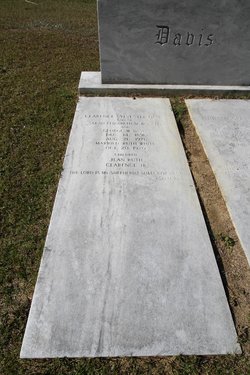
Clarence Sylvester Davis
| Birth | : | 14 Dec 1891 Williamsburg County, South Carolina, USA |
| Death | : | 21 Aug 1971 Florence, Florence County, South Carolina, USA |
| Burial | : | Palmer Cemetery, Marion County, USA |
| Coordinate | : | 34.0205994, -79.3458023 |
| Inscription | : | "The Lord is my shepherd; I shall not want" Psalm 23:1 |
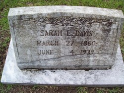
| Description | : | WORLD WAR I Son of George Washington and Sarah Elizabeth McDonald Davis. Clarence married Ruth Leonora White on October 20, 1920. |
frequently asked questions (FAQ):
-
Where is Clarence Sylvester Davis's memorial?
Clarence Sylvester Davis's memorial is located at: Palmer Cemetery, Marion County, USA.
-
When did Clarence Sylvester Davis death?
Clarence Sylvester Davis death on 21 Aug 1971 in Florence, Florence County, South Carolina, USA
-
Where are the coordinates of the Clarence Sylvester Davis's memorial?
Latitude: 34.0205994
Longitude: -79.3458023
Family Members:
Parent
Spouse
Siblings
Children
Flowers:
Nearby Cemetories:
1. Palmer Cemetery
Marion County, USA
Coordinate: 34.0205994, -79.3458023
2. Centerville Baptist Church Cemetery
Centenary, Marion County, USA
Coordinate: 34.0302990, -79.3608240
3. Terrells Bay Cemetery
Marion, Marion County, USA
Coordinate: 34.0383640, -79.3684010
4. Centenary United Methodist Church Cemetery
Marion, Marion County, USA
Coordinate: 34.0653230, -79.3558650
5. Wateree Cemetery
Marion, Marion County, USA
Coordinate: 34.0397200, -79.2902800
6. Munnerlyn Cemetery
Ariel Cross Road, Marion County, USA
Coordinate: 34.0702950, -79.3149240
7. Saint James Cemetery
Marion, Marion County, USA
Coordinate: 34.0737010, -79.3041280
8. Ariel Baptist Church Cemetery
Mullins, Marion County, USA
Coordinate: 34.0789986, -79.3116989
9. Friendship AME Church Cemetery
Gresham, Marion County, USA
Coordinate: 33.9900970, -79.4180260
10. New Cemetery
Marion County, USA
Coordinate: 34.0816994, -79.3118973
11. Zion Cemetery
Aynor, Horry County, USA
Coordinate: 34.0266670, -79.2638900
12. Friendship Baptist Church Cemetery
Friendship, Marion County, USA
Coordinate: 34.0184760, -79.4301530
13. Tabernacle AME Church Cemetery
Gresham, Marion County, USA
Coordinate: 34.0472240, -79.4252780
14. Bethlehem African Methodist Episcopal Church Cemet
Rains, Marion County, USA
Coordinate: 34.0895980, -79.3169480
15. Antley Cemetery
Gresham, Marion County, USA
Coordinate: 33.9473751, -79.3367195
16. Gresham Chapel Freewill Baptist Church Cemetery
Gresham, Marion County, USA
Coordinate: 34.0141650, -79.4360800
17. Antley Richardson Cemetery
Centenary, Marion County, USA
Coordinate: 33.9454500, -79.3386667
18. Red Hill Methodist Church Cemetery
Galivants Ferry, Horry County, USA
Coordinate: 34.0001800, -79.2578170
19. Nebo Baptist Church Cemetery
Gresham, Marion County, USA
Coordinate: 33.9364000, -79.3442920
20. Tabernacle Cemetery
Marion County, USA
Coordinate: 34.0629500, -79.4338990
21. Richardson Family Cemetery
Brittons Neck, Marion County, USA
Coordinate: 33.9346310, -79.3362370
22. Baptist Colored Cemetery
Galivants Ferry, Horry County, USA
Coordinate: 33.9906830, -79.2469640
23. Ford Cemetery
Marion County, USA
Coordinate: 34.0139008, -79.4514008
24. Reedy Creek Baptist Church Cemetery
Marion County, USA
Coordinate: 34.1125700, -79.3331000

