
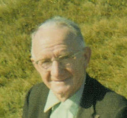
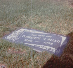
Clarence Vern Allen
| Birth | : | 27 Mar 1899 Lincoln County, Oklahoma, USA |
| Death | : | 11 Aug 1968 South Lake Tahoe, El Dorado County, California, USA |
| Burial | : | Resurrection Cemetery, Vanderbilt, Otsego County, USA |
| Coordinate | : | 45.1133330, -84.6663890 |
| Description | : | Clarence Vern Allen was born March 27, 1899 in Lincoln County, Oklahoma. He was a resident of San Mateo County, California for 42 years. He was a grocer for the John Meyer Company in Millbrae for 25 years, and formerly was a driver for Peninsula Rapid Transit bus lines between San Francisco and San Jose. He drove the first public vehicle across the old San Mateo-Hayward Bridge when it was opened in 1929. He was a member of the Unity Church of Truth, San Mateo, the Independent Order of Foresters, and Retail Clerks' Union. Survivors include his wife Florence; a son,... Read More |
frequently asked questions (FAQ):
-
Where is Clarence Vern Allen's memorial?
Clarence Vern Allen's memorial is located at: Resurrection Cemetery, Vanderbilt, Otsego County, USA.
-
When did Clarence Vern Allen death?
Clarence Vern Allen death on 11 Aug 1968 in South Lake Tahoe, El Dorado County, California, USA
-
Where are the coordinates of the Clarence Vern Allen's memorial?
Latitude: 45.1133330
Longitude: -84.6663890
Family Members:
Parent
Spouse
Siblings

Children
Flowers:


Nearby Cemetories:
1. Resurrection Cemetery
Vanderbilt, Otsego County, USA
Coordinate: 45.1133330, -84.6663890
2. Vanderbilt Cemetery
Vanderbilt, Otsego County, USA
Coordinate: 45.1542015, -84.6624985
3. Fairview Cemetery
Gaylord, Otsego County, USA
Coordinate: 45.0430984, -84.6830978
4. Hudson Cemetery
Boyne Falls, Charlevoix County, USA
Coordinate: 45.1613998, -84.7556000
5. Hallock Cemetery
Elmira Township, Otsego County, USA
Coordinate: 45.0708008, -84.7660980
6. Saint Andrew's Episcopal Church Memorial Garden
Gaylord, Otsego County, USA
Coordinate: 45.0280460, -84.6636050
7. Saint Mary Cemetery
Gaylord, Otsego County, USA
Coordinate: 45.0280991, -84.6532974
8. Lake Louise Memorial Chapel
Boyne Falls, Charlevoix County, USA
Coordinate: 45.1893460, -84.7481690
9. Bagley Cemetery
Gaylord, Otsego County, USA
Coordinate: 45.0175000, -84.6783330
10. Hayes Township Cemetery
Gaylord, Otsego County, USA
Coordinate: 45.0275002, -84.7641983
11. Saint Thomas Cemetery
Elmira, Otsego County, USA
Coordinate: 45.0732994, -84.8471985
12. Gallop Cemetery
Chandler Township, Charlevoix County, USA
Coordinate: 45.2392006, -84.7536011
13. Howard Cemetery
Chandler Township, Charlevoix County, USA
Coordinate: 45.2172012, -84.8364029
14. Maple Hill Cemetery
Warner Township, Antrim County, USA
Coordinate: 45.0653000, -84.8822021
15. Silver Lake Cemetery
Wolverine, Cheboygan County, USA
Coordinate: 45.2722015, -84.6271973
16. Okiron Cemetery
Boyne Falls, Charlevoix County, USA
Coordinate: 45.1828003, -84.9013977
17. Saint Augustine Catholic Cemetery
Boyne Falls, Charlevoix County, USA
Coordinate: 45.1763992, -84.9100037
18. Boyne Valley Cemetery
Boyne Falls, Charlevoix County, USA
Coordinate: 45.1741982, -84.9116974
19. Otsego Lake Township Cemetery
Gaylord, Otsego County, USA
Coordinate: 44.9157982, -84.6857986
20. Mount Hope Cemetery
Johannesburg, Otsego County, USA
Coordinate: 44.9742012, -84.4555969
21. Rondo Cemetery
Indian River, Cheboygan County, USA
Coordinate: 45.3322220, -84.6286110
22. Joy Valley Cemetery
Epsilon, Emmet County, USA
Coordinate: 45.3189011, -84.8191986
23. Brown Cemetery
Jordan Township, Antrim County, USA
Coordinate: 45.0894012, -84.9985962
24. William C Kitchen Family Cemetery
Elmira, Otsego County, USA
Coordinate: 44.9908790, -84.9578680