
| Birth | : | 24 Sep 1848 Brown County, Ohio, USA |
| Death | : | 20 Apr 1918 Gordon, Sheridan County, Nebraska, USA |
| Burial | : | Brownlee Cemetery, Brownlee, Cherry County, USA |
| Coordinate | : | 42.2889100, -100.6234710 |
| Description | : | Clarinda Brown United States Census, 1900 Name: Clarinda Brown Event Type: Census Event Year: 1900 Event Place: Dewey Lake, Loup & Pleasant Hill Precincts, Cherry, Nebraska, United States Gender: Female Age: 53 Marital Status: Married Race: White Race (Original): W Relationship to Head of Household: Wife Relationship to Head of Household (Original): Wife Number of Living Children: 6 Years Married: 34 Birth Date: Sep 1847 Birthplace: Ohio Marriage Year (Estimated): 1866 Father's Birthplace: Ohio Mother's Birthplace: Ohio Mother of how many children: 10 Household Role Gender Age Birthplace Wash H Brown Head M 60 Ohio Clarinda Brown Wife F 53 Ohio Scott Brown Son M 18 Iowa Clare Brown Son M 9 Nebraska District: 43 , Sheet Number and Letter: 2A , Household ID: 30 ,... Read More |
frequently asked questions (FAQ):
-
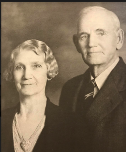
Where is Clarinda Isabel Snyder Brown's memorial?
Clarinda Isabel Snyder Brown's memorial is located at: Brownlee Cemetery, Brownlee, Cherry County, USA.
-
When did Clarinda Isabel Snyder Brown death?
Clarinda Isabel Snyder Brown death on 20 Apr 1918 in Gordon, Sheridan County, Nebraska, USA
-
Where are the coordinates of the Clarinda Isabel Snyder Brown's memorial?
Latitude: 42.2889100
Longitude: -100.6234710
Family Members:
Parent

Spouse
Siblings
Children
Flowers:


Nearby Cemetories:
1. Brownlee Cemetery
Brownlee, Cherry County, USA
Coordinate: 42.2889100, -100.6234710
2. Long Cemetery
Cherry County, USA
Coordinate: 42.2932000, -100.8156000
3. Emanuel Gravesite
Brownlee, Cherry County, USA
Coordinate: 42.3514000, -100.8021500
4. DeWitty Cemetery
Brownlee, Cherry County, USA
Coordinate: 42.3714000, -100.8296000
5. Shady Rest Cemetery
Valentine, Cherry County, USA
Coordinate: 42.4598160, -100.6837050
6. Jimtown Cemetery
Brownlee, Cherry County, USA
Coordinate: 42.1174000, -100.8014500
7. Hartgrave Cemetery
Cherry County, USA
Coordinate: 42.3244500, -100.2680800
8. Seneca Cemetery
Seneca, Thomas County, USA
Coordinate: 42.0364990, -100.8328018
9. James Cemetery
Cherry County, USA
Coordinate: 42.1436005, -100.9760971
10. Virginia Cemetery
Valentine, Cherry County, USA
Coordinate: 42.1432000, -100.9761000
11. Kennedy Cemetery
Kennedy, Cherry County, USA
Coordinate: 42.5248000, -100.8834000
12. Hillcrest Cemetery
Thedford, Thomas County, USA
Coordinate: 41.9673000, -100.5756000
13. Dry Valley Cemetery
Cherry County, USA
Coordinate: 42.2640300, -101.0857200
14. Giles Cemetery
Cherry County, USA
Coordinate: 42.1603012, -100.1828003
15. Purdum Cemetery
Purdum, Blaine County, USA
Coordinate: 42.0638190, -100.2574890
16. Simeon Cemetery
Cherry County, USA
Coordinate: 42.6704000, -100.6629000
17. Cedarview Cemetery
Mullen, Hooker County, USA
Coordinate: 42.0439491, -101.0372009
18. Snake Falls Cemetery
Valentine, Cherry County, USA
Coordinate: 42.6785540, -100.8543170
19. Wolfenden Cemetery
Kennedy, Cherry County, USA
Coordinate: 42.4928500, -101.1621000
20. Mount Hope Cemetery
Wood Lake, Cherry County, USA
Coordinate: 42.6372920, -100.2330200
21. Valley View Cemetery
Brown County, USA
Coordinate: 42.1217003, -100.0488968
22. Lamson Cemetery
Cherry County, USA
Coordinate: 42.6264300, -101.0907900
23. Woodlawn Cemetery
Johnstown, Brown County, USA
Coordinate: 42.5828018, -100.0736008
24. East Woodlawn Cemetery
Johnstown, Brown County, USA
Coordinate: 42.5718994, -100.0382996