Clarinda Jenetta Eselda “Nettie” Hering Beatty
| Birth | : | 6 Sep 1875 Illinois, USA |
| Death | : | 28 May 1932 Davenport, Scott County, Iowa, USA |
| Burial | : | Elm Grove Cemetery, Washington, Washington County, USA |
| Coordinate | : | 41.2861279, -91.7004451 |
| Plot | : | H-3-3 |
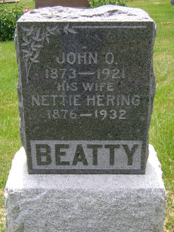
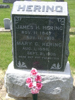
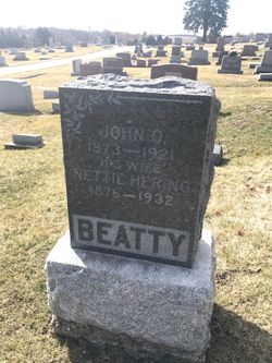
| Description | : | Clarinda Jenetta Eselda Hering was born to James Hiram and Mary Catherine (Detrick) Hering on Sept 6, 1875, in McDonough County, Illinois. Shortly after her son Clarence Loren Hering was born in 1895, the entire family moved to Washington County, Iowa. She was married to John O. Beatty Sept 5, 1897. She remarried to Albert Bullard on Feb 17, 1929, several years after John's death. They resided in Davenport, Scott County, Iowa, where she died on May 28, 1932. She was buried in Elm Grove Cemetery, Washington County, Iowa, beside her first husband, John O. Beatty. |
frequently asked questions (FAQ):
-
Where is Clarinda Jenetta Eselda “Nettie” Hering Beatty's memorial?
Clarinda Jenetta Eselda “Nettie” Hering Beatty's memorial is located at: Elm Grove Cemetery, Washington, Washington County, USA.
-
When did Clarinda Jenetta Eselda “Nettie” Hering Beatty death?
Clarinda Jenetta Eselda “Nettie” Hering Beatty death on 28 May 1932 in Davenport, Scott County, Iowa, USA
-
Where are the coordinates of the Clarinda Jenetta Eselda “Nettie” Hering Beatty's memorial?
Latitude: 41.2861279
Longitude: -91.7004451
Family Members:
Parent
Spouse
Siblings
Children
Flowers:
Nearby Cemetories:
1. Elm Grove Cemetery
Washington, Washington County, USA
Coordinate: 41.2861279, -91.7004451
2. Woodlawn Cemetery
Washington, Washington County, USA
Coordinate: 41.2943300, -91.6968100
3. County Home Cemetery
Washington County, USA
Coordinate: 41.3125162, -91.7223905
4. Moore Cemetery
Washington, Washington County, USA
Coordinate: 41.2583511, -91.6668326
5. Pleasant Hill Cemetery
Washington, Washington County, USA
Coordinate: 41.2435989, -91.6474991
6. Shiloh Cemetery
Washington, Washington County, USA
Coordinate: 41.2250130, -91.6789390
7. Pattison Cemetery
West Chester, Washington County, USA
Coordinate: 41.3365000, -91.7534000
8. Memorial Miller Cemetery
Washington, Washington County, USA
Coordinate: 41.2400500, -91.7735900
9. Schrock-Eureka Cemetery
Washington County, USA
Coordinate: 41.2050018, -91.7125015
10. Benson Cemetery
Washington County, USA
Coordinate: 41.2376912, -91.6108355
11. Craven Cemetery
West Chester, Washington County, USA
Coordinate: 41.3444595, -91.7835035
12. Martin Cemetery
Marion Township, Washington County, USA
Coordinate: 41.2000194, -91.6668323
13. Custer Cemetery
Washington County, USA
Coordinate: 41.1921500, -91.7125900
14. Todd Cemetery
Franklin Township, Washington County, USA
Coordinate: 41.2555705, -91.8196155
15. Plains Cemetery
Washington, Washington County, USA
Coordinate: 41.3808632, -91.7000885
16. Bethel Mennonite Church Cemetery
Washington County, USA
Coordinate: 41.1963997, -91.6596985
17. Grace Hill Cemetery
Washington County, USA
Coordinate: 41.2593994, -91.8281021
18. Sommers Cemetery
Washington County, USA
Coordinate: 41.1927986, -91.6505966
19. Roberts Chapel Cemetery
West Chester, Washington County, USA
Coordinate: 41.3616982, -91.7893982
20. Gatlin Cemetery
Brighton, Washington County, USA
Coordinate: 41.2416818, -91.8251712
21. Ainsworth Cemetery
Ainsworth, Washington County, USA
Coordinate: 41.2943649, -91.5626373
22. Sandy Hook Cemetery
Brighton, Washington County, USA
Coordinate: 41.2050018, -91.7957993
23. West Chester Cemetery
West Chester, Washington County, USA
Coordinate: 41.3521996, -91.8146973
24. New Haven Cemetery
Washington County, USA
Coordinate: 41.2943993, -91.8480988


