
| Birth | : | 8 Jun 1935 Dodge, Dodge County, Nebraska, USA |
| Death | : | 4 Aug 2014 Fremont, Dodge County, Nebraska, USA |
| Burial | : | Calvary Cemetery, Fremont, Dodge County, USA |
| Coordinate | : | 41.4435997, -96.5271988 |
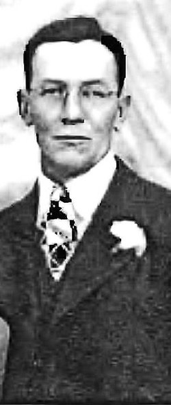
| Description | : | Claude W. Phillips June 8, 1935 - Aug. 4, 2014 Claude W. Phillips, 79 years of Fremont, Nebraska died Monday, August 4, 2014 at his home. Claude was born June 8, 1935 at Dodge, Nebraska to Claude Raymond and Leone (Stangel) Phillips. Claude was raised in the Wisner, Nebraska area and was a 1953 graduate of Wisner High School. He joined the US Army on November 4, 1953 and served during the Korean War until October 13, 1956. Claude married Phyllis Harris on March 14, 1959 at Fremont, Nebraska. They moved to Fremont and lived there where he was employed as an... Read More |
frequently asked questions (FAQ):
-
Where is Claude Wilfred “Phil” Phillips's memorial?
Claude Wilfred “Phil” Phillips's memorial is located at: Calvary Cemetery, Fremont, Dodge County, USA.
-
When did Claude Wilfred “Phil” Phillips death?
Claude Wilfred “Phil” Phillips death on 4 Aug 2014 in Fremont, Dodge County, Nebraska, USA
-
Where are the coordinates of the Claude Wilfred “Phil” Phillips's memorial?
Latitude: 41.4435997
Longitude: -96.5271988
Family Members:
Parent
Spouse

Siblings
Children
Flowers:


Nearby Cemetories:
1. Calvary Cemetery
Fremont, Dodge County, USA
Coordinate: 41.4435997, -96.5271988
2. Ridge Cemetery
Fremont, Dodge County, USA
Coordinate: 41.4425011, -96.5231018
3. Memorial Cemetery
Fremont, Dodge County, USA
Coordinate: 41.4516210, -96.5058210
4. First Congregational Church Columbarium
Fremont, Dodge County, USA
Coordinate: 41.4439000, -96.4974300
5. Saint James Episcopal Church Columbarium
Fremont, Dodge County, USA
Coordinate: 41.4334370, -96.4944130
6. Critten Barrett Cemetery
Cedar Bluffs, Saunders County, USA
Coordinate: 41.4229110, -96.5577650
7. Maple Grove Cemetery
Cedar Bluffs, Saunders County, USA
Coordinate: 41.3880997, -96.6006012
8. Bluffs Trinity Lutheran Cemetery
Fremont, Dodge County, USA
Coordinate: 41.5098080, -96.5973720
9. Wiegand Cemetery
Cedar Bluffs, Saunders County, USA
Coordinate: 41.3819008, -96.6205978
10. Platteville Cemetery
Saunders County, USA
Coordinate: 41.3506012, -96.5410995
11. Pohocco Lutheran Church Cemetery
Leshara, Saunders County, USA
Coordinate: 41.3462715, -96.5026627
12. Hartung Cemetery
Washington County, USA
Coordinate: 41.5182991, -96.4257965
13. Johannes Cemetery
Cedar Bluffs, Saunders County, USA
Coordinate: 41.3788986, -96.6438980
14. Maple Creek Christian Cemetery
Fremont, Dodge County, USA
Coordinate: 41.5390200, -96.5973600
15. Union Cemetery
Cedar Bluffs, Saunders County, USA
Coordinate: 41.3513985, -96.6108017
16. Little Flower Cemetery
Pohocco Township, Saunders County, USA
Coordinate: 41.3350860, -96.4834470
17. Fontanelle Lutheran Cemetery
Fontanelle, Washington County, USA
Coordinate: 41.5384827, -96.4214783
18. Bethel Methodist Cemetery
Dodge County, USA
Coordinate: 41.5583687, -96.6172409
19. Gods Acre Cemetery
Arlington, Washington County, USA
Coordinate: 41.5060997, -96.3677979
20. Saint Marys Cemetery
Saunders County, USA
Coordinate: 41.3932991, -96.6943970
21. Arlington Cemetery
Arlington, Washington County, USA
Coordinate: 41.4597015, -96.3392029
22. Valley Cemetery
Valley, Douglas County, USA
Coordinate: 41.3446999, -96.3794022
23. Green Mound Cemetery
Saunders County, USA
Coordinate: 41.2855988, -96.5250015
24. Hooper Cemetery
Hooper, Dodge County, USA
Coordinate: 41.6032982, -96.5419006