
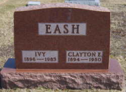
Clayton E Eash
| Birth | : | 11 Jul 1894 Nappanee, Elkhart County, Indiana, USA |
| Death | : | 27 Oct 1980 Goshen, Elkhart County, Indiana, USA |
| Burial | : | Brim Public Cemetery, Brim, Yarriambiack Shire, Australia |
| Coordinate | : | -36.0698620, 142.4301470 |
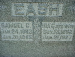
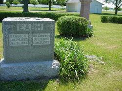
| Description | : | Eash, Clayton E., son of Samuel C. and Ida Kathryn (Nusbaum) Eash, was born at Nappanee, Ind., July 11, 1894; died at Goshen (Ind.) Hospital on Oct. 27, 1980; aged 86 y. On Nov. 29, 1914, he was married to Iva Eash, who survives. Also surviving are one son (Orus), one daughter (Erma-Mrs. Glenn McCreary), 3 grandchildren, and one great-grandchild. He was a member of the First Mennonite Church, where funeral services were held on Oct. 30, in charge of Samuel J. Troyer and Harold Yoder; interment in Forest Grove Cemetery. From: Gospel Herald, Vol. 73, No. 47, November 18,... Read More |
frequently asked questions (FAQ):
-
Where is Clayton E Eash's memorial?
Clayton E Eash's memorial is located at: Brim Public Cemetery, Brim, Yarriambiack Shire, Australia.
-
When did Clayton E Eash death?
Clayton E Eash death on 27 Oct 1980 in Goshen, Elkhart County, Indiana, USA
-
Where are the coordinates of the Clayton E Eash's memorial?
Latitude: -36.0698620
Longitude: 142.4301470
Family Members:
Parent
Spouse

Siblings
Children
Flowers:


Nearby Cemetories:
1. Beulah Cemetery
Beulah, Yarriambiack Shire, Australia
Coordinate: -35.9331810, 142.4501630
2. Warracknabeal Cemetery
Warracknabeal, Yarriambiack Shire, Australia
Coordinate: -36.2657900, 142.3945636
3. Rosebery Public Cemetery
Rosebery, Yarriambiack Shire, Australia
Coordinate: -35.8210390, 142.4507640
4. Kenmare Cemetery
Rainbow, Hindmarsh Shire, Australia
Coordinate: -35.9107730, 142.1842490
5. Sheep Hills Cemetery
Sheep Hills, Yarriambiack Shire, Australia
Coordinate: -36.3641670, 142.5460450
6. Hopetoun Cemetery
Hopetoun, Yarriambiack Shire, Australia
Coordinate: -35.7482802, 142.3699001
7. Katyil Public Cemetery
Katyil, Hindmarsh Shire, Australia
Coordinate: -36.3045090, 142.1195970
8. Jeparit Cemetery
Jeparit, Hindmarsh Shire, Australia
Coordinate: -36.1309040, 141.9959984
9. Katyil Pioneer Cemetery
Katyil, Hindmarsh Shire, Australia
Coordinate: -36.3248600, 142.1195100
10. Watchem Cemetery
Watchem, Buloke Shire, Australia
Coordinate: -36.1484460, 142.8673490
11. Birchip Cemetery
Birchip, Buloke Shire, Australia
Coordinate: -35.9816660, 142.8997540
12. Rainbow Cemetery
Rainbow, Hindmarsh Shire, Australia
Coordinate: -35.9024920, 141.9902870
13. Minyip Cemetery
Minyip, Yarriambiack Shire, Australia
Coordinate: -36.4345482, 142.6355868
14. Lawler Station Private Cemetery
Donald, Buloke Shire, Australia
Coordinate: -36.3700028, 142.7697512
15. Antwerp Cemetery
Antwerp, Hindmarsh Shire, Australia
Coordinate: -36.3057410, 142.0185390
16. Blackheath Cemetery
Blackheath, Horsham Rural City, Australia
Coordinate: -36.4696100, 142.2836400
17. Woomelang Cemetery
Woomelang, Yarriambiack Shire, Australia
Coordinate: -35.6935240, 142.6713470
18. Corack Cemetery
Corack, Buloke Shire, Australia
Coordinate: -36.1552710, 142.9483150
19. Ebenezer Mission Cemetery
Antwerp, Hindmarsh Shire, Australia
Coordinate: -36.3149820, 141.9881000
20. Laen North Cemetery
Laen North, Buloke Shire, Australia
Coordinate: -36.3830890, 142.8247200
21. Upper Regions Cemetery
Wail, Horsham Rural City, Australia
Coordinate: -36.4862800, 142.1176510
22. Dimboola Cemetery
Dimboola, Hindmarsh Shire, Australia
Coordinate: -36.4398920, 142.0242010
23. Jung Cemetery
Jung, Horsham Rural City, Australia
Coordinate: -36.5890000, 142.3723000
24. Donald Cemetery
Donald, Buloke Shire, Australia
Coordinate: -36.3705877, 142.9824445