
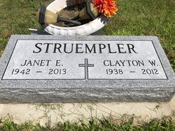
Clayton Wayne “Clay” Struempler
| Birth | : | 25 Dec 1938 Buffalo, Dawson County, Nebraska, USA |
| Death | : | 15 Jan 2012 Holdrege, Phelps County, Nebraska, USA |
| Burial | : | Elwood Cemetery, Elwood, Gosper County, USA |
| Coordinate | : | 40.5999300, -99.8397300 |
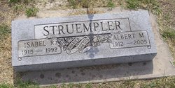
| Description | : | Clayton Wayne "Clay" Struempler, 73, of Loomis died Sunday, Jan. 15, 2012, at Phelps Memorial Health Center in Holdrege. Clay was born Dec. 25, 1938, in the Buffalo community, north of Lexington, to Albert and Isabel (Dirksen) Struempler. In November 1961, he married Janet Dolan at Lexington. Survivors are: wife, Janet Struempler; son, David Struempler and his wife, Debby, of Kearney; grandchildren, Dakota, Cody, Trisha, Daniel and Janet "Janie"; brother, Keith Struempler of Kenai, Alaska; sister, Carol Hopkins and her husband, Ralph, of Eddyville; sister-in-law, Georgia Peden of Missouri; brother-in-law, Bob Dolan and his wife, Colly, of Overton and a host... Read More |
frequently asked questions (FAQ):
-
Where is Clayton Wayne “Clay” Struempler's memorial?
Clayton Wayne “Clay” Struempler's memorial is located at: Elwood Cemetery, Elwood, Gosper County, USA.
-
When did Clayton Wayne “Clay” Struempler death?
Clayton Wayne “Clay” Struempler death on 15 Jan 2012 in Holdrege, Phelps County, Nebraska, USA
-
Where are the coordinates of the Clayton Wayne “Clay” Struempler's memorial?
Latitude: 40.5999300
Longitude: -99.8397300
Family Members:
Parent

Spouse

Flowers:


Nearby Cemetories:
1. Elwood Cemetery
Elwood, Gosper County, USA
Coordinate: 40.5999300, -99.8397300
2. Quakerville Cemetery
Gosper County, USA
Coordinate: 40.6189003, -99.8097000
3. Hope Lutheran Cemetery
Smithfield, Gosper County, USA
Coordinate: 40.5667500, -99.6800000
4. Robb Cemetery
Smithfield, Gosper County, USA
Coordinate: 40.6710691, -99.6996001
5. Homerville Cemetery
Gosper County, USA
Coordinate: 40.4668999, -99.8593979
6. Pioneer Cemetery
Eustis, Frontier County, USA
Coordinate: 40.6632810, -100.0013730
7. Keely Cemetery
Smithfield, Gosper County, USA
Coordinate: 40.5727500, -99.6563500
8. Fairfield Cemetery
Gosper County, USA
Coordinate: 40.4672012, -99.7549973
9. Salem East Cemetery
Gosper County, USA
Coordinate: 40.4972000, -99.9803009
10. Pleasant Grove Cemetery
Gosper County, USA
Coordinate: 40.4664001, -99.9250031
11. Salem West Cemetery
Frontier County, USA
Coordinate: 40.4968987, -99.9886017
12. Eustis East Cemetery
Eustis, Frontier County, USA
Coordinate: 40.6714100, -100.0199780
13. Yoder Cemetery
Smithfield, Gosper County, USA
Coordinate: 40.4957000, -99.6845500
14. McGuire Cemetery
Gosper County, USA
Coordinate: 40.4380989, -99.8664017
15. Immanuel Cemetery
Bertrand, Phelps County, USA
Coordinate: 40.5682983, -99.6283035
16. Westview Cemetery
Eustis, Frontier County, USA
Coordinate: 40.6708740, -100.0380710
17. Evergreen Cemetery
Frontier County, USA
Coordinate: 40.5689011, -100.0571976
18. Highland Cemetery
Bertrand, Phelps County, USA
Coordinate: 40.5194016, -99.6430969
19. Immanuel Lutheran Cemetery
Elwood, Gosper County, USA
Coordinate: 40.4206500, -99.8672000
20. Plum Creek Massacre Cemetery
Phelps County, USA
Coordinate: 40.6726840, -99.6058220
21. Adullam Cemetery
Bertrand, Phelps County, USA
Coordinate: 40.6265000, -99.5856000
22. First United Methodist Church Columbarium
Lexington, Dawson County, USA
Coordinate: 40.7810000, -99.7397000
23. Saint Anns Cemetery
Lexington, Dawson County, USA
Coordinate: 40.7789001, -99.7114029
24. Evergreen Cemetery
Lexington, Dawson County, USA
Coordinate: 40.7639008, -99.6791992