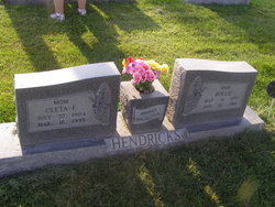
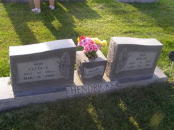
Cleta Franklin Boggs Hendricks
| Birth | : | 22 Jul 1904 Queen City, Schuyler County, Missouri, USA |
| Death | : | 16 Mar 1999 Broken Bow, Custer County, Nebraska, USA |
| Burial | : | Mountain Christian Church Cemetery, Joppa, Harford County, USA |
| Coordinate | : | 39.4674988, -76.3722000 |
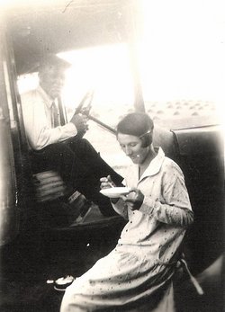
| Description | : | Cleta F. Boggs was the daughter of Robert Frankling Boggs and Dora Maude Martin. She married Rollie Hendricks (son of Ulysses S. Grant Hendricks and Florence Kay) on Feb. 6, 1923 in Broken Bow, Nebraska. At 90+ years old she was still a very active woman and enjoyed deer hunting and spending time with her family. She was laid to rest beside her husband on March 19, 1999. |
frequently asked questions (FAQ):
-
Where is Cleta Franklin Boggs Hendricks's memorial?
Cleta Franklin Boggs Hendricks's memorial is located at: Mountain Christian Church Cemetery, Joppa, Harford County, USA.
-
When did Cleta Franklin Boggs Hendricks death?
Cleta Franklin Boggs Hendricks death on 16 Mar 1999 in Broken Bow, Custer County, Nebraska, USA
-
Where are the coordinates of the Cleta Franklin Boggs Hendricks's memorial?
Latitude: 39.4674988
Longitude: -76.3722000
Family Members:
Spouse
Siblings
Children
Flowers:
Nearby Cemetories:
1. Mountain Christian Church Cemetery
Joppa, Harford County, USA
Coordinate: 39.4674988, -76.3722000
2. McComas Institute Cemetery
Joppa, Harford County, USA
Coordinate: 39.4672200, -76.3583400
3. Union Chapel United Methodist Church Cemetery
Joppa, Harford County, USA
Coordinate: 39.4794000, -76.3780600
4. Franklinville United Presbyterian Church Cemetery
Franklinville, Baltimore County, USA
Coordinate: 39.4481000, -76.3853300
5. Saint Pauls Lutheran Church Cemetery
Kingsville, Baltimore County, USA
Coordinate: 39.4531200, -76.4130000
6. Trinity Lutheran Church Cemetery
Harford County, USA
Coordinate: 39.4397300, -76.3407600
7. Trinity Lutheran Church Cemetery
Joppa, Harford County, USA
Coordinate: 39.4396820, -76.3407900
8. Salem United Methodist Church Cemetery
Kingsville, Baltimore County, USA
Coordinate: 39.4384200, -76.4018467
9. Community Baptist Church Cemetery
Joppa, Harford County, USA
Coordinate: 39.4292000, -76.3698200
10. Saint Johns Episcopal Church Cemetery
Kingsville, Baltimore County, USA
Coordinate: 39.4503800, -76.4173300
11. Saint Stephens Catholic Church Cemetery
Kingsville, Baltimore County, USA
Coordinate: 39.4324400, -76.3976000
12. Tabernacle Mount Zion United Methodist Cemetery
Fallston, Harford County, USA
Coordinate: 39.5057983, -76.3899994
13. Mount Carmel Cemetery
Emmorton, Harford County, USA
Coordinate: 39.4937200, -76.3224600
14. Saint Mary's Episcopal Church Cemetery
Emmorton, Harford County, USA
Coordinate: 39.4879800, -76.3171100
15. Friends Cemetery
Fallston, Harford County, USA
Coordinate: 39.5094000, -76.4058000
16. Fork Christian Church Cemetery
Kingsville, Baltimore County, USA
Coordinate: 39.4663200, -76.4393900
17. Christ Our King Presbyterian Church
Bel Air, Harford County, USA
Coordinate: 39.5165851, -76.3313539
18. Fork United Methodist Church Cemetery
Fork, Baltimore County, USA
Coordinate: 39.4736600, -76.4479600
19. Ebenezer Baptist Church Cemetery
Joppa, Harford County, USA
Coordinate: 39.4118200, -76.3459700
20. John Wesley United Methodist Church Cemetery
Magnolia, Harford County, USA
Coordinate: 39.4118200, -76.3459700
21. Heavenly Waters Cemetery
Harford County, USA
Coordinate: 39.5293999, -76.3747025
22. Copely Parish Church of the Resurrection
Joppatowne, Harford County, USA
Coordinate: 39.4058914, -76.3639908
23. David Lee Family Cemetery
Bel Air, Harford County, USA
Coordinate: 39.5319958, -76.3866033
24. Saint Francis DeSales Catholic Church Cemetery
Abingdon, Harford County, USA
Coordinate: 39.4650002, -76.2855988


