
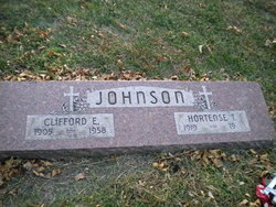
Clifford Earl “Jack” Johnson
| Birth | : | 4 Feb 1905 |
| Death | : | 10 Oct 1958 |
| Burial | : | Dorotea Kyrkogård, Dorotea, Dorotea kommun, Sweden |
| Coordinate | : | 64.2638277, 16.4119750 |
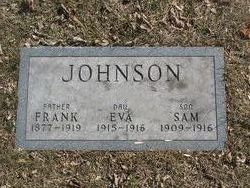
| Plot | : | Edgewood Lot 186 - 4 |
frequently asked questions (FAQ):
-
Where is Clifford Earl “Jack” Johnson's memorial?
Clifford Earl “Jack” Johnson's memorial is located at: Dorotea Kyrkogård, Dorotea, Dorotea kommun, Sweden.
-
When did Clifford Earl “Jack” Johnson death?
Clifford Earl “Jack” Johnson death on 10 Oct 1958 in
-
Where are the coordinates of the Clifford Earl “Jack” Johnson's memorial?
Latitude: 64.2638277
Longitude: 16.4119750
Family Members:
Parent


Spouse
Siblings
Flowers:


Nearby Cemetories:
1. Dorotea Kyrkogård
Dorotea, Dorotea kommun, Sweden
Coordinate: 64.2638277, 16.4119750
2. Tasjo Kyrkogard
Tasjo, Strömsunds kommun, Sweden
Coordinate: 64.2225463, 15.9010377
3. Alanäs Kyrka
Alanas, Strömsunds kommun, Sweden
Coordinate: 64.1660384, 15.6906290
4. Vilhelmina Church Cemetery
Vilhelmina, Vilhelmina kommun, Sweden
Coordinate: 64.6300714, 16.6437804
5. Fjällsjö Kyrkogård
Backe, Sollefteå kommun, Sweden
Coordinate: 63.8137773, 16.3948079
6. Latikberg kyrkogård
Latikberg, Vilhelmina kommun, Sweden
Coordinate: 64.6440076, 17.0792300
7. Hammerdals Churchyard
Hammerdal, Strömsunds kommun, Sweden
Coordinate: 63.5952681, 15.3627832
8. Laxsjö kyrkogård
Laxsjo, Krokoms kommun, Sweden
Coordinate: 63.8101290, 14.8006710
9. Ådals-Lidens kyrkogård
Nasaker, Sollefteå kommun, Sweden
Coordinate: 63.4447998, 16.8913940
10. Åskilje Cemetery
Askilje, Storumans kommun, Sweden
Coordinate: 64.9083320, 17.8625680
11. Resele Kyrkogärd
Resele, Sollefteå kommun, Sweden
Coordinate: 63.3303373, 17.0750766
12. Föllinge kyrka
Föllinge, Krokoms kommun, Sweden
Coordinate: 63.6659000, 14.6175500
13. Lugnet kyrkogård
Lycksele, Lycksele kommun, Sweden
Coordinate: 64.6072000, 18.6502000
14. Berglunda Kyrkogård
Lycksele, Lycksele kommun, Sweden
Coordinate: 64.5634000, 18.6954000
15. Lycksele Gamla Kyrkogården
Lycksele, Lycksele kommun, Sweden
Coordinate: 64.5988370, 18.6718580
16. Helgums Kyrkogård
Helgumsbyn, Sollefteå kommun, Sweden
Coordinate: 63.2200485, 16.8263023
17. Häggenås kyrkogård
Häggenås, Östersunds kommun, Sweden
Coordinate: 63.3948900, 14.9117200
18. Björksele kyrkogård
Bjorksele, Lycksele kommun, Sweden
Coordinate: 64.9884300, 18.5157800
19. Sollefteå-Boteå Cemetery
Sollefteå, Sollefteå kommun, Sweden
Coordinate: 63.1621090, 17.2784100
20. Gargnäs Kyrkogård
Gargnas, Sorsele kommun, Sweden
Coordinate: 65.3120659, 17.9621481
21. Mo Kyrkogard
Moliden, Örnsköldsviks kommun, Sweden
Coordinate: 63.3759500, 18.4610800
22. Krematorium Hoppets Kapell
Ostersund, Östersunds kommun, Sweden
Coordinate: 63.2522770, 14.6690600
23. Granö kyrkogård
Granon, Vindelns kommun, Sweden
Coordinate: 64.2214400, 19.3540000
24. Ås kyrkogård
As, Sollefteå kommun, Sweden
Coordinate: 63.2486990, 14.5627210